
The earthquake and tsunami in Indonesia caused widespread destruction and killed more than 2,000 people.
As the amount of destruction was still coming to light, Reuters used a series of...
-
 View projectExplore a landscape of the covers of over 5,000 books that appeared in the New York Times's "Best Selling" and "Also Selling" books lists. The covers are grouped using machine learning, allowing...
 -
 View projectSome countries (most of them "great" democracies) invest a lot of money in their military spending and the production / transfer of arms. I used processing (well, p5.js) to visualise the top 10...
 -
 View projectBetween 1973 and 2013, $367 billion of development aid has been distributed worldwide. Who has provided aid, and who has received it? This deceptively simple graphic shows the flows of global...
 -
 View projectJapanese government publishes approximately 26,000 land values every year. We plotted these values from 1989, the peak of real estate bubble, to 2019, the latest. You can see the latest value or...
 -
 View projectFor this project, am exploring the question ‘How Can Sound be Visualised?’ I am intrigued by how I can reveal the sounds around me into a visual form, and am experimenting with the ways I can do...
 -
 View projectNanjing Ming City Wall is the world's largest city wall, it tells the history of a dynasty, it carries the memories of those ancient times and now became the footprints of that. The work...
 -
 View projectMy aim here is to push the boundaries of inequality data visualisation. Usual visualisations are 2D, i.e. "Screenland". I present selected UN gender issues/data in a mix of graphic and physical...
 -
 View projectA VR app for laymen and astronomers that visualizes X-ray data of astronomical objects from the ESA satellite XMM-Newton. Data of >1,000 X-ray sources generate unique data objects. Their sizes,...
 -
 View project‘100 mujeres pioneras’ (100 Pioneering Women) is a visual approach to ‘No me cuentes cuentos’ (don't tell me stories) project. A Prodigioso Volcán and Kloshletter agencies initiative to highlight...
 -
 View projectKekki is an experienced game analyst. In this interactive visualization, he guides us through the landscape of mobile games while traversing through a beautiful forest. The adventure is available...
 -
 View projectThis is a chart about time data of European capitals. It visualizes differences in local sunset times and length of day using a clock chart rather than a map. Selected European capitals are...
 -
 View projectReuters set up a camera on top of our Delhi bureau, capturing hundreds of images over October-November, historically the worst period of air quality each year in the Indian capital. The graphics...
 -
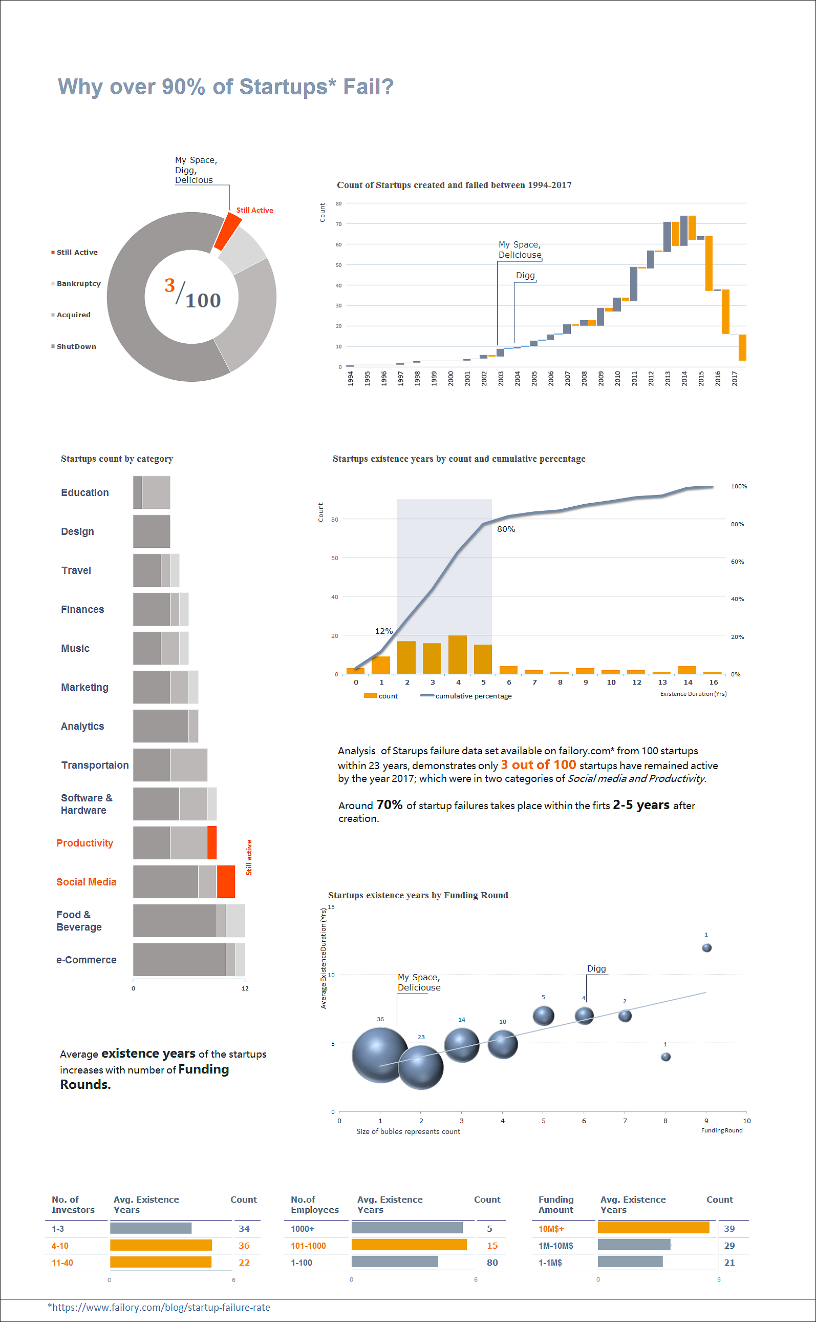
 View projectA new analysis conducted on startups failure data set available on www.failory.com* from 100 startups within a 23 years, shows only 3 out of 100 startups have remained active by the year 2017;...
 -
 View projectThe vision of the future of healthcare. Patients will be engaged, providing them with smart technology so they can closely monitor themselves. They can have devices that will constantly measure...
 -
 View projectHave you ever wondered which cities have won the most championships in the four major sports leagues? In this visualization, each petal of the flower chart represents one of the four major sports...
 -
 View projectSince 1976, the Ebola virus has killed nearly 15,000 people. Though most out the epidemic covers large swathes of Sub-Saharan Africa, it has plagued countries the Democratic Republic of Congo and...
 -
 View projectA visualization of my son's sleep pattern from birth to his first birthday. Crochet border surrounding a double knit body. Each row represents a single day. Each stitch represents 6 minutes of time...
 -
 View projectSometimes we have to challenge readers' sensibility so we can build a better world. This cut-out infographic includes a mid-upper-arm circumference (or MUAC) bracelet, which is used to help assess...
 -
 View projectAn infographic poster explaining the issue of food waste and suggesting solutions for preserving food and reducing waste.
 -
 View projectMawangdui No.1 Han Tomb is an influential cultural heritage in China. It has a lot of elegant unearthed cultural relics which includes a variety of fabrics.This work makes a brief introduction of...
 -
 View projectThis stunning piece of digital journalism is the result of a successful collaboration between the ABC's Tokyo bureau and the Story Lab team here in Australia. Super Kamiokande is a giant science...
 -
 View projectBauhaus is celebrating its 100th anniversary in 2019. This work intends to shed some light on the female students as their contribution to Bauhaus and their story are barely recognised...
 -
 View projectBackground: Creating visualizations that include multiple dimensions of the data while preserving spatial structure and readability is challenging. Here we demonstrate the use of geofaceting to...
 -
 View projectVisualization attempts to address the most common threat for local residents in Nepal - landslide collapsing over the road network. There are many technical solutions that could protect the road...
 -
 View projectLanguage is an extension of individual identity, as vocabulary is freely chosen on social, cultural, and economic base. This map presents the Digital Humanities Conference 2019 through its...
 -
 View projectThe entrant has supplied multiple files for this work [1] [2] The Water Scarcity Clock is an interactive data visualization webtool created to raise awareness about the reality of water as a...


