
Faced with some of the steepest home prices in the United States, Bay Area residents are searching for cheaper cities to settle down.
-
 View projectA few weeks ago I set on trying out new WebGL 2.0 features with deck.gl. WebGL 2.0 brings plenty of new goodies to be used for game development, creative coding and data visualization like...
 -
 View projectThis is a visual information map of the tour around Yellowstone Park. A tour route was drawn up in the information map, including nine recommended sites. How far are they? What are the recommended...
 -
 View projectWild animals are an indispensable part of nature and an important partner of ours. In the past hundred years, due to the continuous deterioration of the living environment of mankind and...
 -
 View projectTransitFlow is an open-source software tool that enables users to easily generate spatial-temporal visualizations of transit frequency in cities around the world!
 -
 View projectA multi-angle analysis of the 2022 UK housing market, which breaks the (positively-skewed) dataset into quartile groups based on house price with a top outliers group for the stately homes and...
 -
 View projectThe Sagrada Família is a one-of-a-kind temple, for its origins, foundation and purpose. Fruit of the work of genius architect Antoni Gaudi, the project was promoted by the people for the people....
 -
 View projectIt's not a hoax, a myth, or a conspiracy among scienctists. As we argue about the path we take, let's recall the facts that compel the journey.
 -
 View projectThis map, created using the U.S. Department of Defense's THOR dataset, shows every recorded bombing mission of the Vietnam War. Each mission is plotted as a single semi-transparent point....
 -
 View projectInsight Lane is a volunteer-driven project that combines open data with the power of data science to predict the likelihood of crashes happening on a city's road network. In order to present the...
 -
 View projectIn October 2018, the first official Central Park Squirrel Census was conducted in New York City. The project — which involved 323 volunteer Squirrel Sighters and took two years to plan, execute,...
 -
 View projectWe are living in the anthropocene—an epoch characterized by humankind's profound impact on the planet. This poster presents seven geographic views of human activity and influence: it highlights...
 -
 View projectVisualization of traffic flow from around the Greater Montreal Area. Time-stamped commuter GPS trajectories are visualized from 3 transit modalities: cars, public transit, and bikes. 1 month's...
 -
 View projectRoad killings in Taiwan are becoming more and more severe, with gray in the background to indicate "roads", and red gradients for species extinction to show the spread of blood, like only...
 -
 View projectWhen it comes to restaurants, every US city has a unique identity. Austin, TX is renowned for its BBQ. New York City is densely packed with pizza-by-the-slice. San Francisco and LA compete on...
 -
 View projectAn interactive map of all of London's nature reserves and designated wildlife sites, Nature Reserves of London encourages Londoners and visitors alike to explore the wealth of woodland, wetland,...
 -
 View projectA dynamic roadmap through the early developments of data visualization, in the style of John Ogilby’s 1675 Atlas. Original illustrations and interactive design guide you through time past...
 -
 View projectA data visualization using a dataset from the Open Data BCN portal focused on complaints registered by the Barcelona City Council for five years from 2016 to 2020. An analysis into the...
 -
 View projectNewly released data shows the true extent of industrial fishing. More than 55 percent of the surface of the world’s oceans is fished, with China accounting for vastly more than any other country.
 -
 View projectThis project translates a bird's migration journey from South Arabian Peninsula to North Asia into a series of map images in traditional East Asian landscape painting style with haiku poems...
 -
 View project‘Inspiring a Movement: The Warming Stripes’ is a visualisation depicting and evaluation how Ed Hawkin’s famous ‘Warming Stripes’ graphic has grown over the last 4 years, becoming a global symbol of...
 -
 View projectThe Tunguska event: A blast from the past’ is a special TASS project that takes an in-depth look at a large mysterious explosion that occurred on the morning of June 30, 1908. TASS reconstructed...
 -
 View projectUnveil MIT's cupboard usage insights! My project deciphers trends in MIT's varied areas – academic, maker spaces, dining, admin, and sports. Visualize data to optimize usage, allocate smartly, and...
 -
 View projectRoad kills often occur at night when vision is less clear.I imagined the desperate eyes of animals lying on the road after being hit by a car.Design with the shape of the pupil.Pupils shrink when...
 -
 View projectIntuitive interactive maps & charts visualising an extensive & authoritative database of international trade in natural resources. Chatham House’s resource trade database reorganizes UN...
 -
View projectThe choropleth map shows the mean Euclidian distance to roads for each of the 11.224 municipalities of Germany. The darker the color, the larger the average distance. The visualization makes use...
-
 View projectWhat if Earth’s terrain was created by nighttime lights? This 3D web mapping experiment sheds some light on the question with a complete resculpting of our planet's surface. Human light...
 -
 View projectThis visualisation focuses on Africa, to highlight a positive light on the continents and showcases champions of renewable energy.
 -
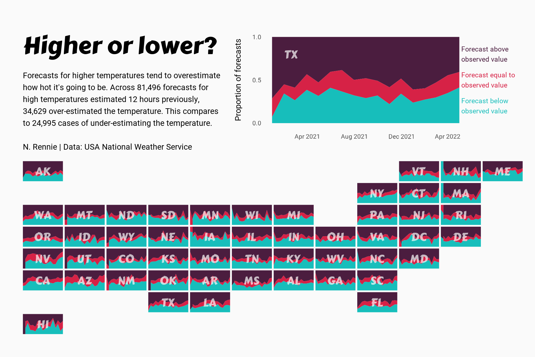
 View projectThis chart visualises the accuracy of high temperature forecasts made by the USA National Weather Service between January 2021 and June 2022, within a 12 hour window. Proportional area charts show...
