
An interactive map of the pollution of rivers in Ukraine based on data from the State Agency of Water Resources. There are more than 400 river water control points on the map. You can view up to 16...
-
 View projectThe seas cover 71% of the Earth and are home to the vast majority of living things on the planet. Water temperatures are rising. In a five part series, Reuters looks at the implications of the...
 -
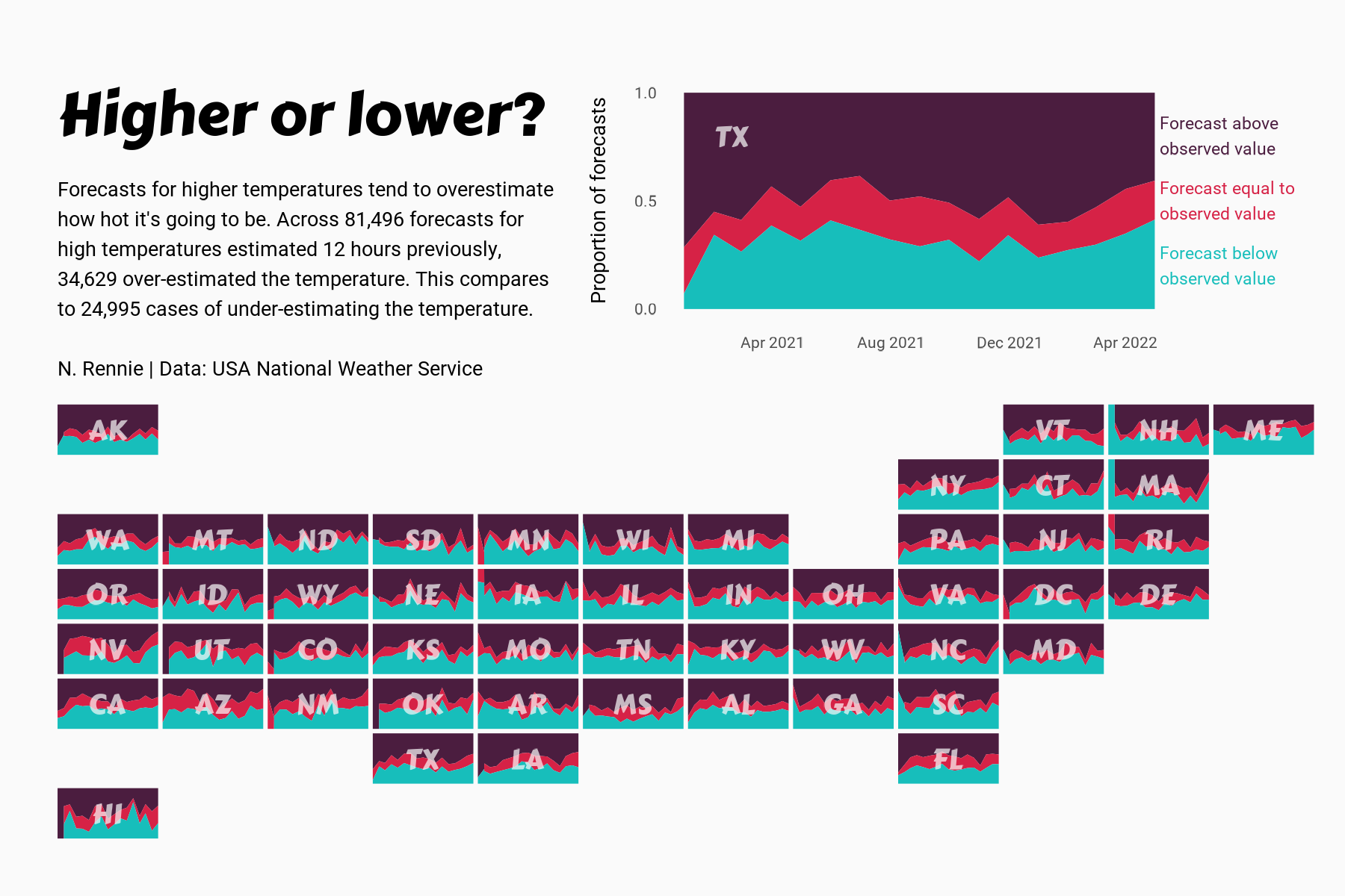
 View projectThis chart visualises the accuracy of high temperature forecasts made by the USA National Weather Service between January 2021 and June 2022, within a 12 hour window. Proportional area charts show...
 -
 View projectNowadays tourists are more aware of the rental available in their selected destinations. All in all, Airbnb has seen a phenomenal rise in Latam and this DataViz highlights a few trends to give an...
 -
 View projectWild animals are an indispensable part of nature and an important partner of ours. In the past hundred years, due to the continuous deterioration of the living environment of mankind and...
 -
 View projectThe war in Ukraine is different: The global public can follow the developments in real-time, unlike in past conflicts. Our interactive map is an attempt to map this new reality of war. The map...
 -
 View projectThe District Department of Transportation (DDOT) of Washington DC manages and maintains transportation infrastructure. In the district, many commuters use public transport instead of a personal...
 -
 View projectThis visualisation shows the number of captive killer whales still alive in the US today. Amongst the 20 Killer Whales in captivity in the US that are still alive today, all but one are...
 -
 View projectWith climate change raising Arctic temperatures faster than the global average, wildfires are shifting poleward where the flames blaze through boreal forest and tundra and release vast amounts of...
 -
 View projectWe humans have been making maps of the world since the beginnings of our culture, from the babylonian Imago Mundi to the latest big data based digital maps. Here a new world map is created from...
 -
 View projectAn exploration into high altitude mountaineering. This project takes two different approaches to visualise data on the highest peaks on earth – one digital, one analogue. Drawing on data from...
 -
 View projectTo showcase the newcomers for hostel vacancy and warden can easily identify the number of rooms capacity left in the design.
 -
 View projectThis dataviz shows different types of forest fires in Russia over time. You can see how the dynamic of them changes over tie among different territories.
 -
 View projectThis interactive narrative aims to illustrate the contrasting disparities in the lives and opportunities of children in Eastern and Western Europe, using the metaphor of children's books. Not all...
 -
 View projectOn Jan. 14, the Iranian tanker Sanchi sank in the worst oil shipping disaster in decades, killing all 32 crew onboard. Water contaminated by the cargo of toxic condensate oil and the ship’s fuel...
 -
 View projectFour full-page graphics show that no place in the world is safe from the consequences of climate change. Raging Fires devastate huge areas, and even in temperate climate zones, droughts wreck the...
 -
 View projectThis was a data-driven story created in collaboration with Birdlife International and the Spoon-billed Sandpiper Task Force. It portrays how the conservation of migratory birds, which travel...
 -
 View projectThis data experience compares our near ravenous appetite for cheap polyester clothes fuelled by fast fashion brands against the slowness of it’s discard and decay. The pile — a comparison Two...
 -
 View projectNumber of cherry blossom trees per 293 x 365 meters (represented by each hexagon) planted in Washington D.C.
 -
 View projectThe visualization shows different types of positions and hierarchies in the security system that manages and controls the well-being of the campus. Moreover the allotment of security guards at each...
 -
 View projectClimagon is a website which allows its visitors to select various datasets (temperature, precipitation, sea ice, sea temperature) and select a location within the range of the dataset. The site...
 -
 View projectVortex View is a public app for browsing, visualizing and downloading tropical cyclone imagery from the NOAA GOES-16 satellite mesoscale dataset. GOES-16 mesoscales are moveable satellite regions...
 -
 View projectThis graph illustrates the nine major landforms and five major terrain types in China in the form of an infographic, also showing the formation of each landform and partial area ratio of terrain to...
 -
 View projectTrading the Fragile: An Insight into the CITES and IUCN databases is a data-driven project aiming to shed light on the work of these two organizations. By highlighting the most traded species...
 -
 View projectThe U.S. and Russia are the world's largest arms exporters. But where are the arms going? This map illustrates the flows U.S. and USSR / Russia arms sales from 1950 through 2017, using publicly...
 -
 View projectMore frequent and intense extreme heat is one of the major impacts of climate change. To assess how the incidence of extreme heat has changed over time, Carbon Brief examined which regions...
 -
 View projectWe commemorate 150th anniversary of the unification of Buda, Pest and Óbuda into Budapest with a series of 50 alternative maps, mainly produced from open source or publicly available data. The maps...


