
Illegal gold mining activity has risen sharply over the last five years in Brazil’s indigenous Yanomami reservation in the heart of the Amazonian rainforest, a Reuters review of exclusive data...
-
 View projectThis visualisation shows the Holocene volcanoes of Japan as illuminated points atop shaded relief. The visualisation is created using the free and open-source R statistical computing language,...
 -
 View projectThis project transforms the data from the Heat, Health, and Habitat project (https://vis.csh.ac.at/heat-health-habitats/) into a dynamic auditory experience, designed as a full music composition....
 -
 View projectInstant data analysis and visual overview of the results of the 2017 general election in Germany as they came in. A team effort that included work from designers, developers and data...
 -
 View projectThis interactive data explorer is built by acclaimed designer Moritz Stefaner and his team at Truth & Beauty, using Google Trends data. It’s also the second in the Google News Lab’s series of...
 -
 View projectThis poster provides information on the impact plastic bags within our ocean and aquatic life. my. The plastic bag is meant to dump out the information seen in this poster, mimicking the plastic...
 -
 View projectAbout 35% of current jobs in the UK are at high risk of computerisation over the following 20 years, according to a study by researchers at Oxford University and Deloitte. Oxford University...
 -
 View projectCONTEXT: The ocean has a strong influence on Earth's weather and climate, affecting our daily weather and shaping long-term climate changes. In the realm of scientific studies, acquiring the...
 -
 View projectDrWhy is a collection of tools for Explainable AI (XAI). It involves a set of data visualizations, explaining different aspects of predictive Machine Learning models and their performance. I’ve...
 -
 View projectFor the best viewing experience, please view in fullscreen and increase Video Quality to 4k or HD in Settings. Subtitles available for easy reading. Long Covid is an invisible yet often...
 -
 View projectLondon Greenground Map is an independent project by graphic designer Helen Ilus to support the sustainable ideas of National Park City movement. The idea of the Greenground Map is to envision...
 -
 View projectAn infographic story about how quantum computing works. The last pages are about the research/project TU Delft EEMC faculty is doing in this area. This infographic story is mainly created for...
 -
 View projectTraditional "year in charts" retrospectives usually consist of rehashed newsroom graphics from the year gone. This project takes a fundamentally different approach. Instead of revisiting the key...
 -
 View project‘Play Bikes!: A Sonic Alleycat’ is a multi-sensory data experience built as a love letter to bikes, to maps, and to data. Personal bike ride data collected from a fitness app is transformed into...
 -
 View projectThis interactive article presents a so-called “explorable explainer” of the k-means clustering algorithm. It attempts to push the envelope of how visual explanations can be designed on an...
 -
 View projectTo celebrate the 50th anniversary of the most giant leap for mankind, we visualise all the missions to the Moon.
 -
 View projectThe lower 48 United States use a total of about 60,000 million gallons of freshwater per day in the process of thermoelectric power production (https://usgs.water.gov/vizlab/water-availability)....
 -
 View projectLast year, Quinnipiac University polled Texans on the Senate race between Democrat Beto O'Rourke and Republican Ted Cruz, which Ted went on to win. The poll asked about the issues and...
 -
 View projectcf. city flows is a comparative visualization of urban bike mobility designed to help citizens casually analyze bike-sharing systems in the context of a public exhibition space. Three...
 -
 View projectHALO is a 3-dimensional object that maps complex data flows into an aggregate, and intuitive data picture. It is an intelligent digital object who’s colour, form and behavioural characteristics...
 -
 View projectThe project is a network visualization of my Facebook friends – each one of the 2300 friends is represented as a node with size proportional to the number of messages exchanged between me and them....
 -
 View projectHow much does a pack of Marlboro typically cost in Boston, MA? Which city has the most expensive McMeal? As the most expensive city in the U.S., is everything in New York City overpriced compared...
 -
 View projectThese three information charts describe the morphological characteristics, growth and development of fern, gymnosperms and angiosperms, and their respective information. I have illustrated each of...
 -
 View projectThe ESA Star Mapper visualisation is an exploration of some central aspects of astrometric star catalogues, using data from ESA's Hipparcos mission.
 -
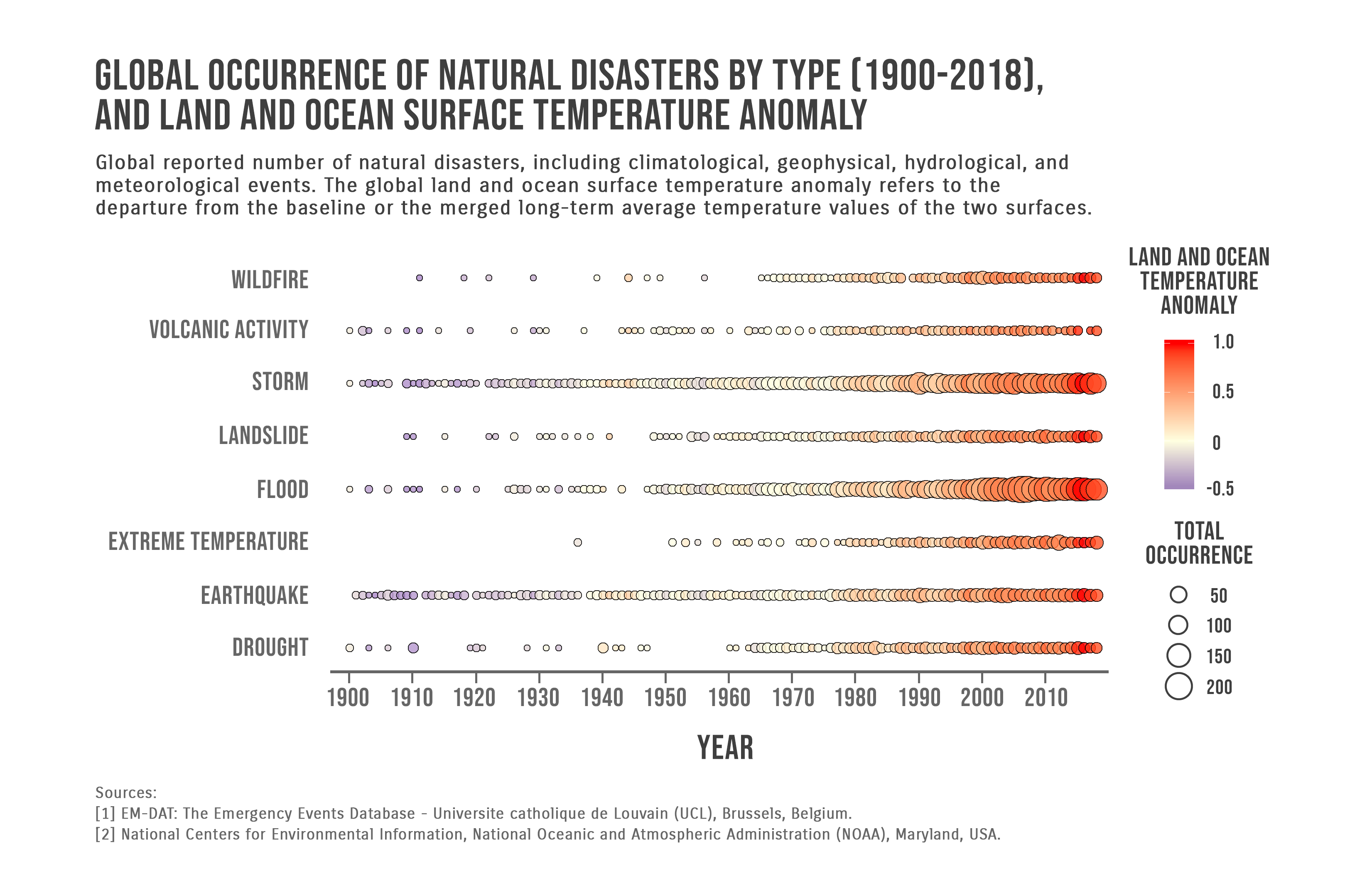
 View projectGlobal reported number of natural disasters, including climatological, geophysical, hydrological, and meteorological events. The global land and ocean surface temperature anomaly refers to the...
 -
 View projectNever before has Twitter played such a prominent role in an election. If Clinton or Trump wants to say something or react to news — even if it's at 3 a.m. — they don't need to coordinate a press...
 -
 View projectIf humans were ever able to get their hands on just one asteroid, it would be a game-changer. That’s because the value of many asteroids are measured in the quintillions of dollars, which makes...
 -
 View projectIn the map “City of Women”—which appears in the forthcoming book “Nonstop Metropolis,” a creative atlas of New York City that I co-authored with Joshua Jelly-Schapiro—we tried on what it would look...
 -
 View projectThis tangible data visualization compares the production percentages of aquaculture, wild catch, and bottom trawling over six decades, highlighting the number of threatened species.
 -
 View projectWhat are satellites used for, who owns them and where do they orbit the Earth? Satellite Explorer is a web application that answers these questions by providing a visualization of the active...