
Drug overdoses now kill more Americans than HIV/AIDS did at its peak. These maps and charts tell the story.
-
 View projectThere are large discrepancies among European nations in the representation of women in management boards. A new law in the European Union requires listed companies to meet gender balance targets on...
 -
 View projectThe interactive chart depicts every goal in all World Cup football games by minute, whether from open play, a penalty or an own goal (including extra time). Filters let one drill down by country,...
 -
 View projectApp prospect for data management company Stibo Systems. A normal 2D chart provides an overview of only 2 parameters. With 3D columns you get a 3rd value as well - much quicker than comparing 2...
 -
 View projectDepression affects millions, with prevalence varying by demographics and region. To illustrate this, we developed an interactive visualization, allowing users to explore depression prevalence in...
 -
 View projectThe ENTITY MAPPER is an open source web application for visualizing qualitative data as an interactive node-link diagram. By abstracting away the time-consuming process of constructing a...
 -
 View projectAlmost half of Americans believe that immigrants make crime worse. But the data tells a different story. This visual piece examines the relationship between immigration and crime in American cities...
 -
 View projectStatistics from the Grand Slam tennis competitions give ammo to no end of data stories. From looking at the success of nations over time; the differences between the men’s and women’s game; to...
 -
 View projectMobile advertising is on the rise. Millward Brown Brasil developed a study to understand more of this universe. Share of time spent has changed with the possibilities brought by smartphone...
 -
 View projectThe project is an animation that illustrates a research where scientists have been able to create a very accurate estimate of the total number of trees in the world. This animation illustrates the...
 -
 View projectThis piece of data visualization aims to deconstruct and represent the emigration flow of Spain between the years of 2008 and 2013. The system that I created to visualize the total number...
 -
 View projectAtelierdatasheet — Rethinking Spreadsheets as a Design Medium Atelierdatasheet transforms Google Sheets into a visually compelling and interactive platform for data storytelling, challenging the...
 -
 View projectThe objective of this multiplatform project composed of a poster and a web application is visualize data to demonstrate how the mood of cells affects metabolic age, breaking paradigms about...
 -
 View projectA video of an interactive visualisation that demonstrates how colour (green, white and grey) is used to display associations, and dissociations, in data. This is fun way of educating people in how...
 -
 View projectSeries of infographics on the lack of sustainability of nuclear energy for the magazine "Energy & Environment". On six pages, the graphics are devoted to exciting facts and problematic aspects...
 -
 View projectI spent a week on the couch with Tarantino’s oeuvre, watching people die and swear a blue streak. When someone was killed by a gun or a sword or a venomous snake, or someone was called a...
 -
 View projectThis is the third piece in a triptych of three titled MAD (Music-Astronomy-Drugs). There is a shared musical, celestial, and psychedelic quality to all three pieces. Here I depict the safety (or...
 -
 View projectA project exploring income inequality in countries through the Palma Ratio, represented with an experimental tangible visualization, transforming income disparity into engaging narratives to...
 -
 View projectHow does Paris look as seen through the lens of thousands of photographers? This interactive installation provides an immersive dive into the image space spanned by thousands photos taken across...
 -
 View projectThe increasing amount of data overloading us on a daily basis requires us to be more selective in how we divide our attention. Being able to quickly assess what information is relevant to you...
 -
 View project"The Language of Design Internships" is a set of playful yet informative infographics analyzing the current landscape of design internship listings. These visual tools help young designers better...
 -
 View projectThis was a goofy piece — it’s not every day a writer has a spreadsheet full of sports mascots to peruse. The article is a deep dive into the history of sports mascots, and the visualization is a...
 -
 View projectBeing an expat in the UK, 'how a society treats outsiders and minority groups' has become one of the subjects that I care about the most. South Korea, my home country, in my memory wasn't the...
 -
 View projectThrough the years, Taylor Swift has changed her musical style drastically, going from country radio to pop to indie – and now, as she re-records her old albums, she is cycling through the genres...
 -
 View project‘Not on our watch’ is our journey to illustrate the spirit of female activists and the political violence they faced during the COVID-19 pandemic burst. It is about spreading the stories of...
 -
 View projectI love cooking food. I love eating food. I love sharing food. But it breaks my heart that so many people in the world don't share that luxury. Join me as we explore the impact of undernourishment...
 -
 View projectWhen geometry and human intuition meet: What becomes of the intersection between pragmatic visual tools and emotion? Everybody worries about something. Worrying is an act of the everyday that...
 -
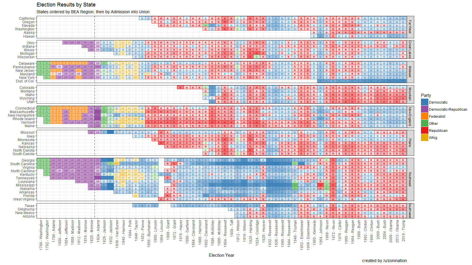
 View projectOpen Source visualization of Election Results by state, party, year, and candidate, sorted by region.

