
Robin considers herself to be strong, stable, and composed, and she also cries at the drop of a hat. She records, analyzes, and visualizes 394 outbursts that occur over a year and a half to gain a...
-
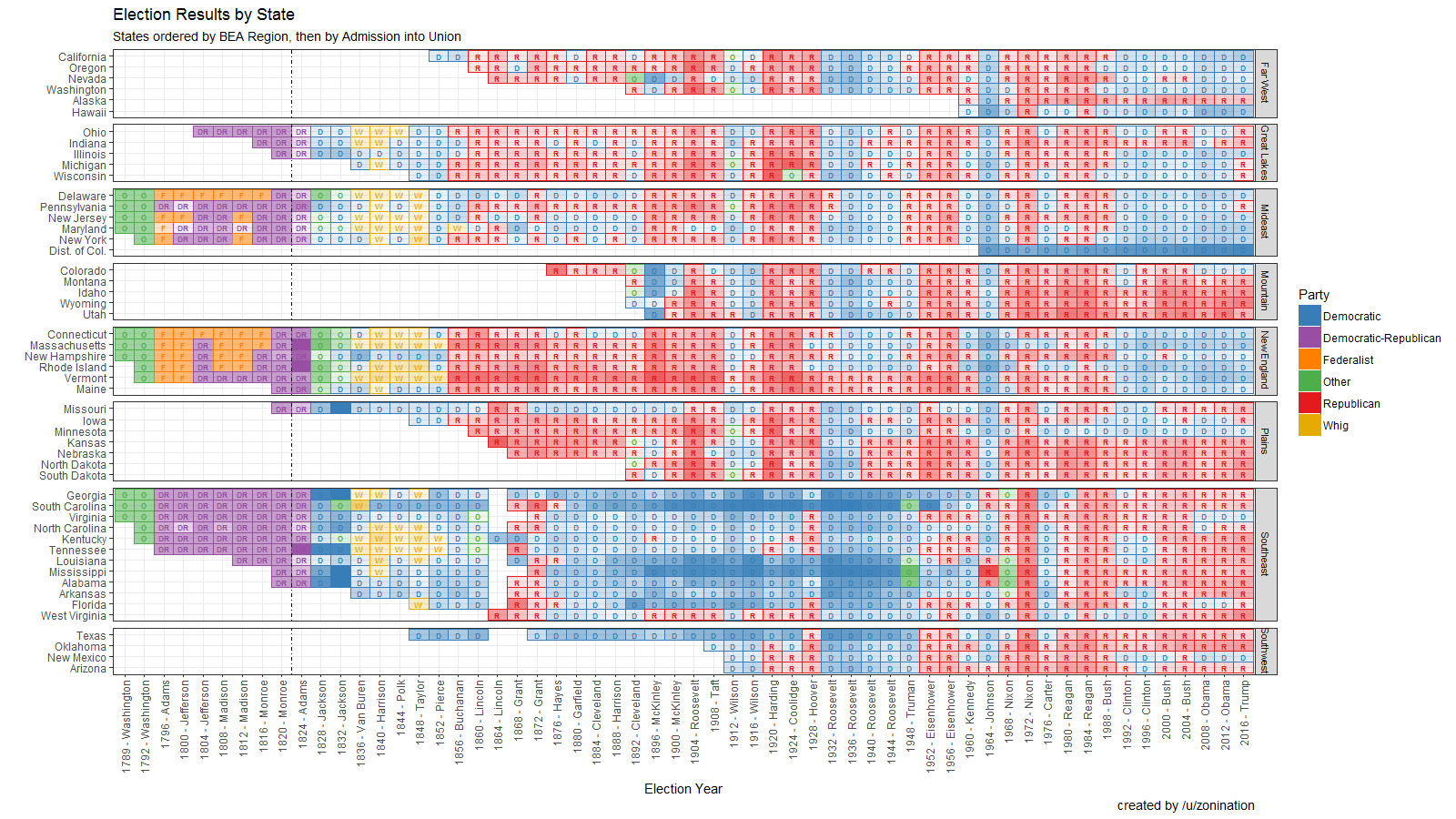
 View projectOpen Source visualization of Election Results by state, party, year, and candidate, sorted by region.
 -
 View projectOne passionate entomologist poetically describes and ranks over 70 species' painful stings.
 -
 View projectKaledata is an Italian hand drawn infographic news blog. Articles are published twice a month on average and focus on worldwide news and current events. Kaledata is in Italian but has an English...
 -
 View projectThis project was inspired by Dear-Data.com, a wonderful collaboration between Giorgia Lupi and Stefanie Posavec. We, Jeffrey Shaffer and Andy Kriebel, decided to follow in their footsteps and...
 -
 View projectThe Toronto Symphony Orchestra’s ‘listening guides’ make use of symbols and morse code-like notation to aid the experience of a live performance.
 -
 View projectThe worst coral bleaching event in recorded history currently threatens reefs across the globe and scientists warn the situation may not improve anytime soon.The threat to corals around the world...
 -
 View projectWikiverse is galactic reimagining of Wikipedia with up to 250 thousand articles to explore and discover. In this miniverse, articles are turned into stars which naturally cluster by similarity....
 -
 View projectAccording to a recent report from the Freedom House, 61% of Internet users live in countries where government criticism is restricted. Though widespread globally, censorship is not evenly...
 -
 View projectA visual exploration of the spatial patterns in the endings of German town and village names.
 -
 View projectA look at the history of Batman & Superman in the context of the changes in American culture, politics and economics over the last century. The aim was to try and understand how these...
 -
 View projectInfographic summarizes the cases of corruption investigated and prosecuted in Valencia and its main defendants. It is shown in chronological order each case to see in the time from when...
 -
 View projectOn July 21, 2016, Donald Trump gave his acceptance speech for the Republican presidential nomination at the RNC. Since the beginning of the primary season, Trump has been accused by pundits of...
 -
 View projectNative Berliners are a minority in Berlin. This interactive application shows for the first time which cities the new arrivals come from.
 -
 View projectParticles and fragments of light slip by in a stream of time and space to portray the compelling experience of driving. »Porsche BlackBox« reimagines this connection by visualizing racing data as...
 -
 View projectIssues that go unmeasured often remain unresolved. Understanding children's current situation and their problems is vital when dealing with future problems in our society, which is why we need to...
 -
 View projectIn celebration of the start of the Rio 2016 Olympic Games this month, Visa looks back look back at major historical and cultural milestones in the Olympic and Paralympic Games since 1986.
 -
 View projectWhen Barbie debuted at the 1959 New York Toy Fair, she was the first fashion doll with a three-dimensional adult form. The men who dominated the toy industry told her creator, Ruth Handler, that...
 -
 View projectWhat are investors looking for in companies and founders? The data looks at 890 U.S. startups that were founded from 2009-2015 and received at least $20 million in VC and other equity funding.
 -
 View projectAn interactive analysis revealing how the Star Wars trailers frequently repeat scenes while parsing out bits of new material to generate attention.
 -
 View projectdelvv.io would like to submit the graphic work from our very own Rising Star, Anja Laubsher. We are a qualitative research startup based out of Johannesburg, South Africa. We live in a continent...
 -
 View projectWhat lobbyist are you? This infographic prompts the user to answer questions about climate and energy policy and identify to an organization (NGO, company or professional organization) who shares...
 -
 View projectInfographic for BOAT International Magazine showing the components of a dream yacht/ice-breaker.
 -
 View projectSonnet Signatures visualizes each of Shakespeare's 154 sonnets by charting the letters used within each one. The signatures are not meant to assign meaning but to inspire others to think about...
 -
 View projectAnother Life Taken is a project that illustrates abortion in America at the central point of contention — the humanity of the unborn. It represents each child individually as a fetus rather than...
 -
 View projectIntersections of major roads have been given nicknames like “mixing bowl,” “spaghetti junction,” and “knot”—invoking images of tangled messes, but there's beauty in the chaos. Applying colors...
 -
 View projectIn the lead-up to the much-anticipated release of Star Wars: The Force Awakens, we set out to log and chart every scene from every Star Wars movie. Yes, we even suffered through the prequels. We...
 -
 View projectInformation design is to use reasonable design methods to analyze and organize the data and information, and make the data, passing on the information in a reasonable way, let the complex noise to...

