
Goal 11 of the United Nations Conference on Sustainable Development is to make cities and human settlements inclusive, safe, resilient and sustainable. This project starts with UN Goal 11 and...
-
 View projectThis visualization shows the changes in energy consumption for 60 countries over a 50 year period. Each chart shows not only how total energy consumption has changed over that time, but also how...
 -
 View projectSearch popularity, or how frequently a term is searched in proportion to all other queries for a given location, can reveal what excites or interests the underlying population. This...
 -
 View projectA network map showing all of the New York City Subway Lines and ranking of line by length of line and number of stations along line.
 -
 View project“Red sunsets, a natural miracle?” project illustrates the relationship between the presence of air pollution and the “red” color of sunsets. The approach to data visualisation has here the aim to...
 -
 View projectA multi-angle analysis of the 2022 UK housing market, which breaks the (positively-skewed) dataset into quartile groups based on house price with a top outliers group for the stately homes and...
 -
 View projectTo showcase the newcomers for hostel vacancy and warden can easily identify the number of rooms capacity left in the design.
 -
 View projectOur transport system generates huge amounts of data. For instance, on a typical weekday, we collect 19 million smartcard ticketing transactions that offer a valuable insight into the number of...
 -
 View projectThe visualization work presented here arises from the desire to synthesize and visualize in a single graphic document the multifaceted methodological structure of the Monitoring Program that the...
 -
 View projectCommemorating Earth Overshoot Day, the day of the year on which we run out of Earth's resources for the given year, with a call to action.
 -
 View projectThis interactive infographic captures the beauty and of population both at the country level and for each continent. Hovering over a country will highlight the country in the map key at the top....
 -
 View projectMeet America's busiest bikes! We sifted bike share data from four cities throughout the USA - Chicago, New York, Washington and Philadelphia. Our goal was to find the busiest bike and map its...
 -
 View projectIn order to allow an in-depth, more detailed exploration of the issues addressed in the interactive survey, a further step in the application user-flow allows people to access more complex...
 -
 View projectAn immersive motion-sensitive experience showing the disastrous impact of plastic in our oceans. The Blue Paradox is a powerful and thought-provoking exhibit that raises awareness of the plastic...
 -
 View projectWhen 2020 Census data was released, FiveThirtyEight visual journalists Ryan Best and Elena Mejía used the new data to explore the extent of which racial segregation caused by redlining was still...
 -
 View projectWith Climate Change, my country Portugal has been witnessing a drastic worsening of its water supply. Severe droughts have been decimating up to 90% of the territory over the past years. Besides...
 -
 View projectToday, cities all over the world are working to provide their residents with services that are accessible within a 15 minute walk. But, which cities are leading this change? Which cities need to...
 -
 View projectThis website is the virtual counterpart to the book ‘Parliament’. The book explores the double-sided relationship between space and politics by documenting and comparing the plenary halls of the...
 -
 View projectA few years ago, my kids were taking very long showers. I wanted a way to explain to them how important water is and should be used sparingly but in a very simplified way that they could relate,...
 -
 View projectYou’ve likely seen the population density map of the United States in one form or another. A lot of people per square mile reside in big cities, fewer people reside in suburban areas, and a lot...
 -
 View projectData is nothing without context. How can we understand a city without first understanding the characteristics of a normal or typical city? I crunched the numbers on eight measures of 917 cities to...
 -
 View projectThe most famous train ever, a legend, an epic journey surrounded by a shade of mistery, glamour and the charm of the past golden times. How well do you know the Orient Express, its lines and the...
 -
 View projectCNN’s Houses of Parliament interactive offers audiences a unique experience: the chance to step inside one of the world’s most iconic buildings in a purpose-built 360 immersive environment. Users...
 -
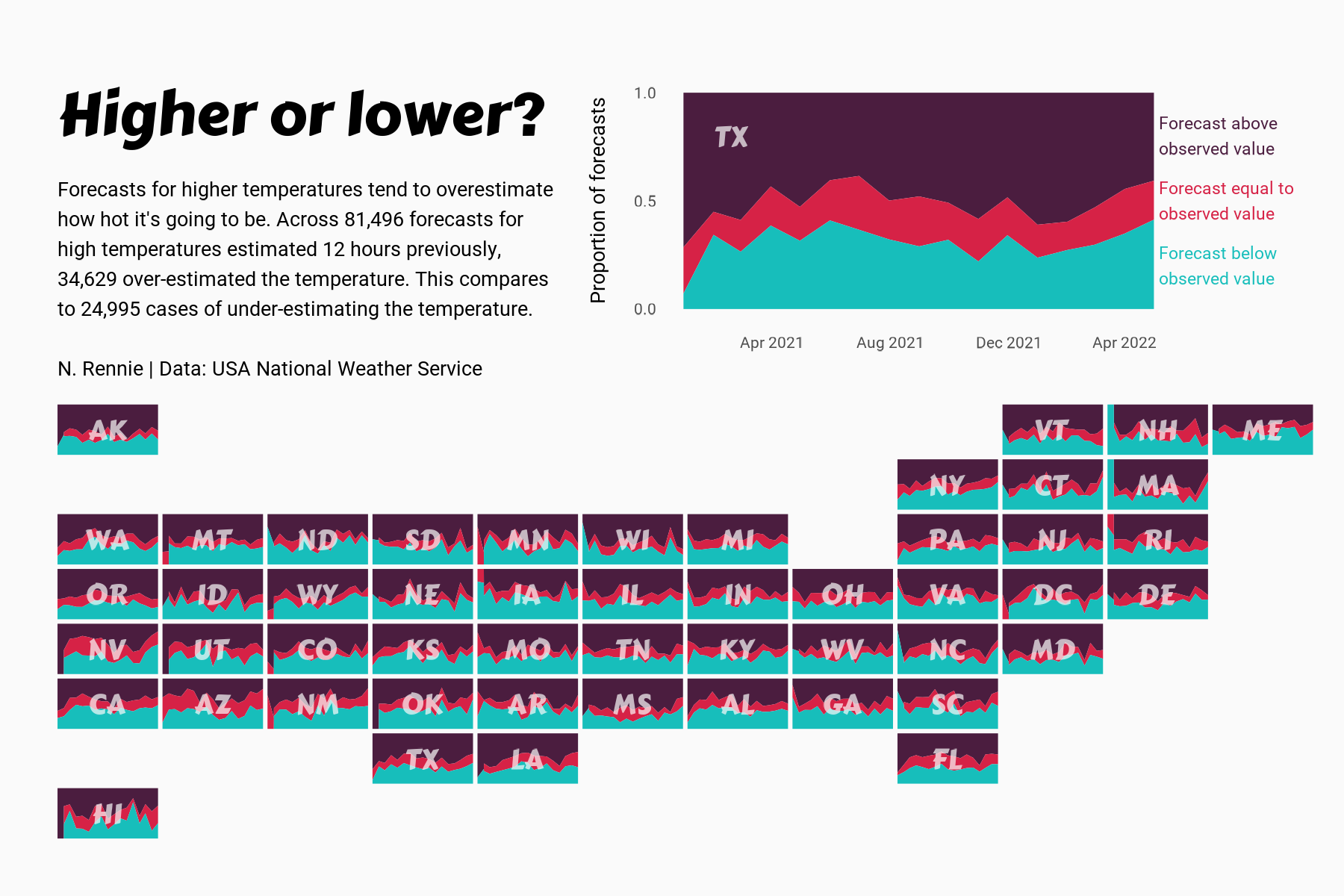
 View projectThis chart visualises the accuracy of high temperature forecasts made by the USA National Weather Service between January 2021 and June 2022, within a 12 hour window. Proportional area charts show...
 -
 View projectThis project has two goals. One is to show the remarkable relationship between the historical geography of American slavery and the present-day patterns of mass incarceration. But second, the maps...
 -
 View projectIn recent years, Indonesia has witnessed a significant rise in earthquake activity, attributed to its location within the seismic hotspot known as the Ring of Fire. The convergence of tectonic...
 -
 View projectIn the first week of 2018, a record-setting deep freeze has forced temperatures in some places on the east coast nearly 20-degrees lower than average. Meanwhile, parts of California and the...
 -
 View projectGetting a bird’s eye view of them and following the individual paths as they weave through what might resemble spaghetti, some sort of flower or a bow-tie. It’s a beauty that cannot be...
 -
 View projectAnimal movement represents the continuous succession of locations of an individual over time. By changes in movement, animals react to both internal stimuli and the environment. State-of-the-art...
