CityAccessMap by Leonardo Nicoletti
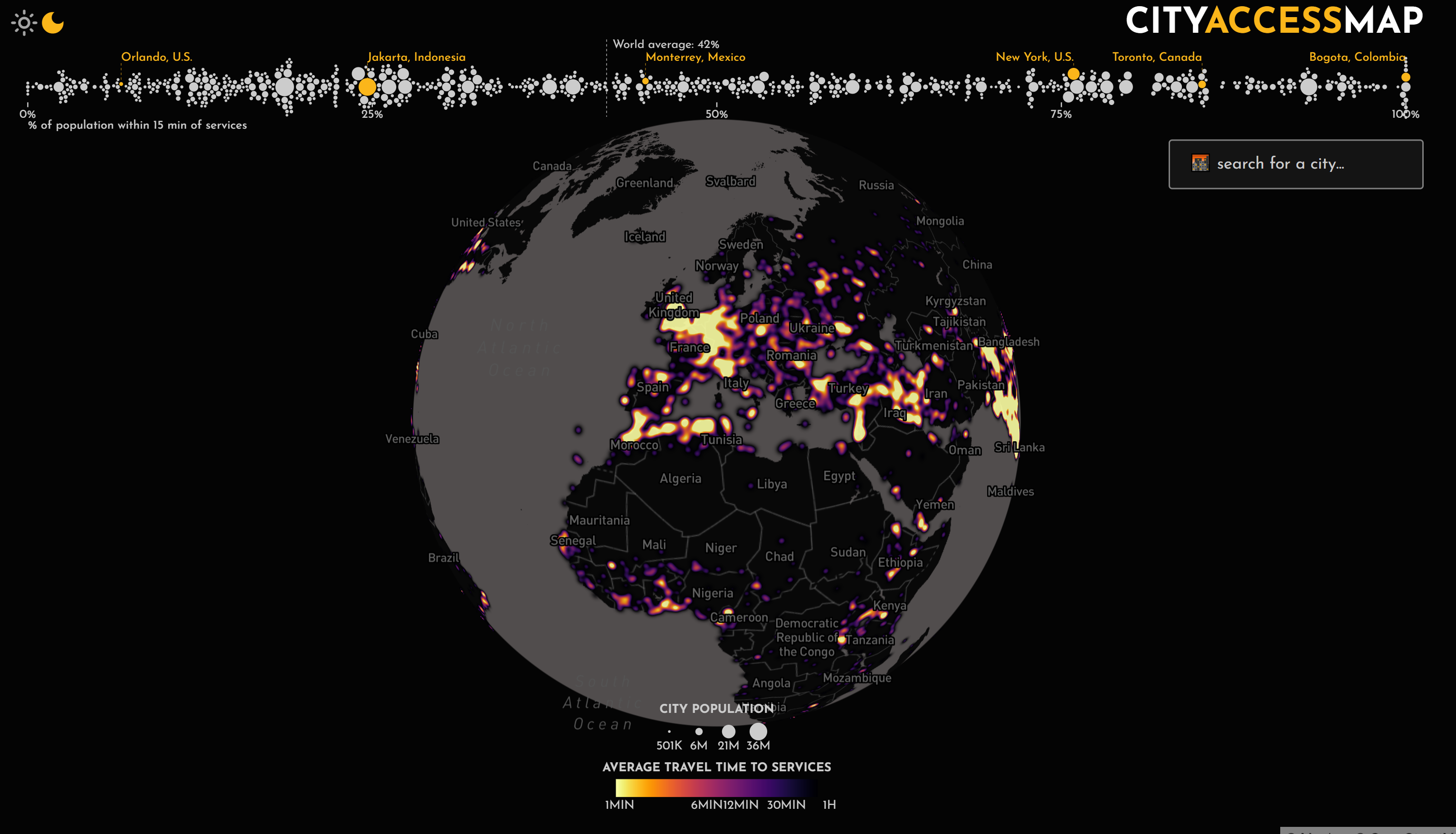
Today, cities all over the world are working to provide their residents with services that are accessible within a 15 minute walk. But, which cities are leading this change? Which cities need to invest in public infrastructure to improve access to services for their residents? CityAccessMap was developed to provide public administrations, metropolitan authorities, municipalities, NGOs, private organizations, and residents, with the necessary tools to answer these questions. It's an open source app for global-scale urban accessibility insights. The tool can be used to obtain both high-level and granular-level insights into how access to different services is distributed across the space and residents of their city. In using this tool, policy makers and members of the public can ultimately understand how close they are to achieving a “15-Minute City”, and identify distributional inequalities in access to essential services. I hope that this application can help facilitate more equitable decision-making related to mobility, land-use, and social policies.
This web application is the outcome of a year-long research project that I conducted while a graduate researcher in the CUSP (Computational Urban Science and Policy) lab at Delft University of Technology. While I was completing my master’s degree, I lead a research effort aimed at measuring equality in access to urban infrastructure in cities across the world. In collaboration with two other researchers (Trivik Verma, Mikhail Sirenko), I have developed an open source computational framework to assist planners in the design of more equitable accessibility policies. This framework uses open data, network science, and machine learning to identify distributional inequalities in access to infrastructure for every city in the world. Over the past two years, my colleagues and I have presented this research at numerous international conferences, including the 6th International Conference on Computational Social Science (IC2S2) hosted at the Massachusetts Institute of Technology (MIT) (https://www.youtube.com/watch?v=eKHCV8vJykM&ab_channel=LeonardoNicoletti). In addition, this research has also led to a scientific journal submission (https://arxiv.org/abs/2203.13784). This scientific article is scheduled to be published in Environment and Planning B: Urban Analytics and City Science in the next few weeks/months.
I built this web application (https://cityaccessmap.com/) using Svelte, Mapbox.js, and D3.js. In developing this application, I used open data from OpenStreetMap. I also used Global Human Settlement Layer (GHSL) open data provided by the European Commission. In combining these data sets, I have quantified and visualized accessibility to a variety of different services via foot (i.e. walking) for (nearly) any given city in the world that is home to more than 100,000 residents (i.e., ~3500 cities globally).
-
Credits
-
Award
-
Categories
-
See more


