
Planet’s goal of imaging the entirety of the Earth every day became achievable with the unprecedented fleet of small satellites, called “doves”. The animation showcases one day in the life of these...
-
 View projectThe western winds and the North-Atlantic ocean current make the European winter a relatively mild one, but this season still comes in many different shapes accross the continent. Explore them all...
 -
 View projectThe project of a fantasy subway in Rome meeting the main famous buildings and monuments in more than 2700 years of history. They are 8 tematic lines about historic periods: (L1) Ancient Roman...
 -
 View projectThe visualization work presented here arises from the desire to synthesize and visualize in a single graphic document the multifaceted methodological structure of the Monitoring Program that the...
 -
 View projectIn 2016, Shanghai Tower, the tallest skyscraper in China opened to the public, which contributed to the completeness of Shanghai skyline. Since the early 1990s, Lujiazui has been developed...
 -
 View projectThe Washington Post’s in-house creative agency WP BrandStudio and Bank of America partnered to produce a year-long series showcasing how responsible growth strategies are helping customers and...
 -
 View projectRoad killings in Taiwan are becoming more and more severe, with gray in the background to indicate "roads", and red gradients for species extinction to show the spread of blood, like only...
 -
 View projectOcean acidification is a significant impact caused by ongoing climate change. The ongoing decrease in the pH value of seawater has negatively affected the ecosystems. The interactive...
 -
 View projectAs our access to fresh water becomes threatened and the demand for virtual water is increasing, the need for understanding and knowing our virtual water footprint is essential. This series of...
 -
 View projectIf I'm on a road trip, I'm stopping at McDonald's. I wanted to look at McDonald's restaurants in a way that shows just how far they stretch across the country, while always maintaining those...
 -
 View projectClimagon is a website which allows its visitors to select various datasets (temperature, precipitation, sea ice, sea temperature) and select a location within the range of the dataset. The site...
 -
 View projectThe Infographic show important details about the mess in the university campus for the students.
 -
 View projectThis Infographic project reveals the relationship between the population of three cities; Singapore, Hong Kong and Mexico City and the amount of flora species affected by the overpopulation of...
 -
 View project“Red sunsets, a natural miracle?” project illustrates the relationship between the presence of air pollution and the “red” color of sunsets. The approach to data visualisation has here the aim to...
 -
 View projectUsing Tableau and Mapbox to map 100 years of Platypus sightings in Tasmania. This map highlights where further areas of protection are needed to help protect this wonderful species.
 -
 View projectAn interactive Tableau visualization of direct flights to campgrounds in the continental United States from various U.S. airports.
 -
 View projectGlobally, climate change claims 150,000 lives per year. Gramener partnered with Evergreen under the Microsoft AI for Earth grant to curb climate change impact with a predictive urban planning tool....
 -
 View projectThe HERE Traffic Analytics suite of data products gives enterprises and government customers insights into what happens on roadways. It helps them make informed decisions, for example, on future...
 -
 View projectImagine there is a new universal eco-rule: that the right to easily enjoy beach access derives from your plastic waste management. The more plastic you feed the ocean, the farther you walk to the...
 -
 View projectThis visualisation explores which countries in 2010 produced the largest amount of plastic waste and what percentage of this was inadequately managed, but more importantly how does this management...
 -
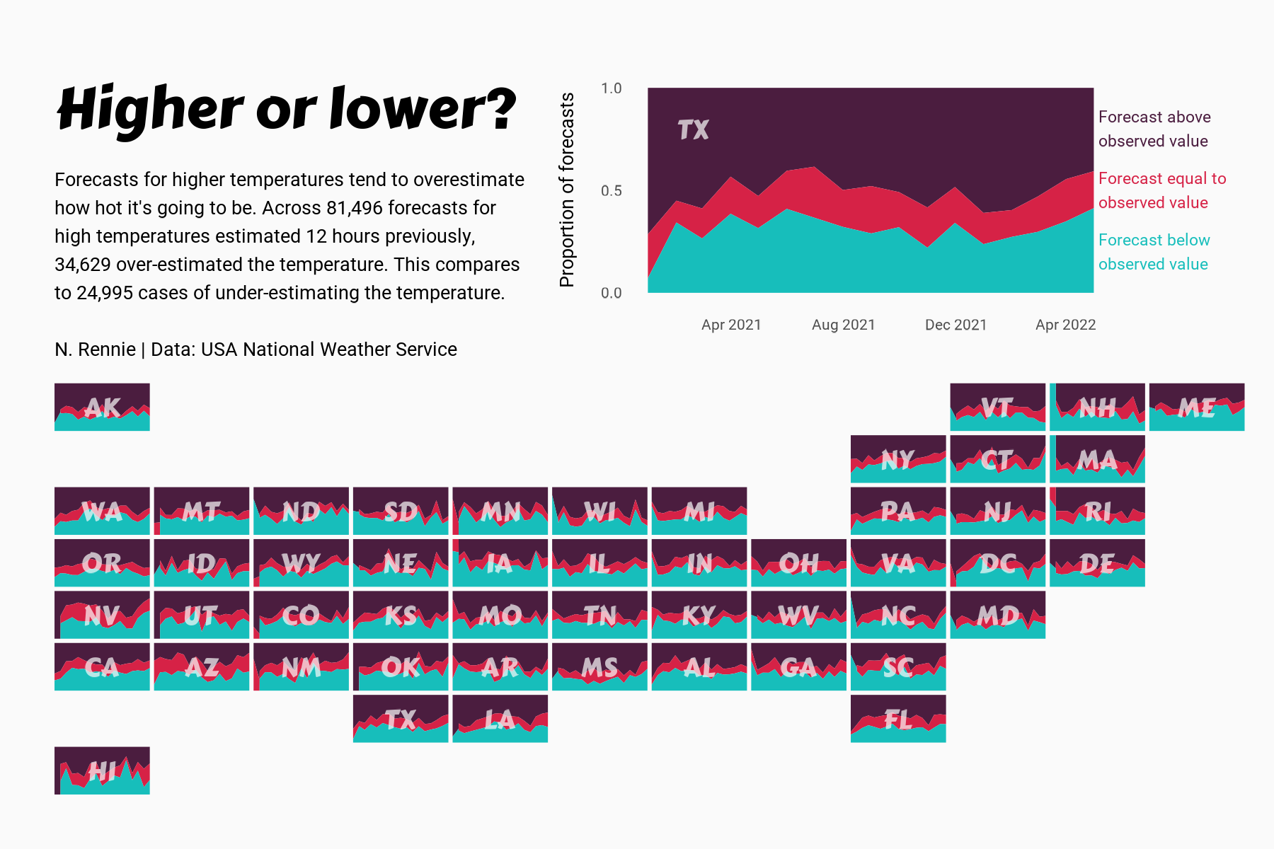
 View projectThis chart visualises the accuracy of high temperature forecasts made by the USA National Weather Service between January 2021 and June 2022, within a 12 hour window. Proportional area charts show...
 -
 View projectFor background color, I chose "red, black, white", which describe "blood, death, angel respectively. Then, the red line in the top of the picture looks like the flow of blood. Most importantly, the...
 -
 View projectCreated using Tableau and Mapbox, this visualisation maps the reported sightings of Sea Turtles and modelled plastic pollution in the oceans around Greece.
 -
 View projectAn exploration into high altitude mountaineering. This project takes two different approaches to visualise data on the highest peaks on earth – one digital, one analogue. Drawing on data from...
 -
 View projectAvailable for anyone to explore today. Travel through time. See change. Make discoveries.
 -
 View projectThe Nakaiy Almanac visually merges indigenous knowledge and weather data, showcasing the value of an intricate and historic understanding of weather patterns and of emerging changes in weather...
 -
 View projectthe placement of cctv cameras in the college campus and how many cases are solved through it. Data of solved, unsolved and total cases as well as the types of camera used in the campus and their...
 -
 View projectOur OS Maps users created over 300,000 public routes across Great Britain in 2018 (covering some 2,950,000 miles…) and we were curious to see where you most (and least) enjoy exploring. The...
 -
 View projectBirds start singing in the early morning. What can be heard in the morning reveals a lot about the human impact on nature and biodiversity. This article explains how human activity has impacted the...
