
In the current uprising of right-wing politics, the discussions often focus on a view of the world in its present state rather than understanding it as a historical process. Migration, ethnical...
-
 View projectA team of data and graphics reporters spent months talking with experts, analyzing and visualizing historical tornado data, and creating detailed explanatory graphics in order to explain a shift in...
 -
 View projectAn exploration into high altitude mountaineering. This project takes two different approaches to visualise data on the highest peaks on earth – one digital, one analogue. Drawing on data from...
 -
 View projectThis is a visualization showing the number of steps walked between the months of January and April. This viz was intended to show the days I was laziest at hence the days with the least number of...
 -
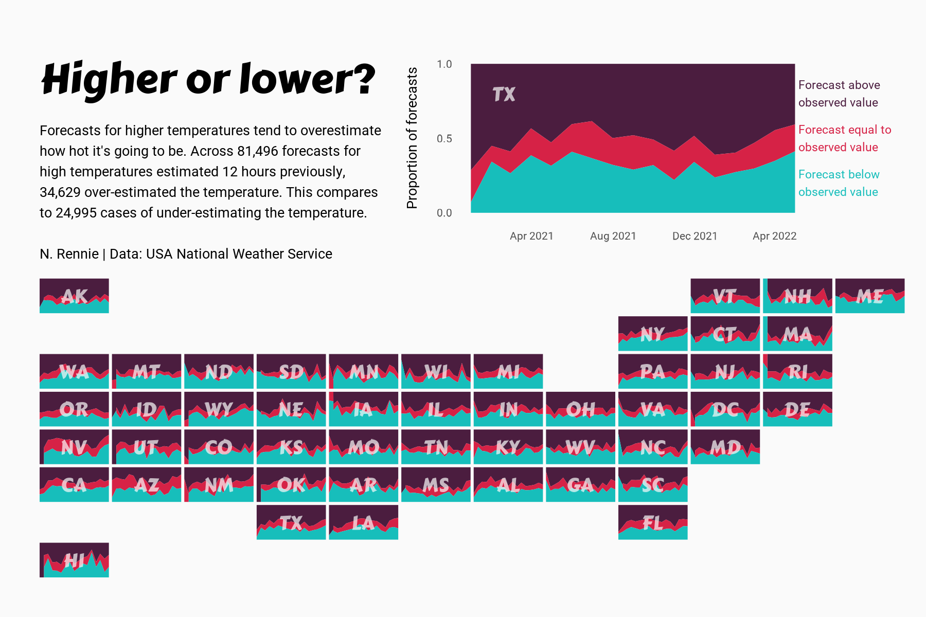
 View projectThis chart visualises the accuracy of high temperature forecasts made by the USA National Weather Service between January 2021 and June 2022, within a 12 hour window. Proportional area charts show...
 -
 View projectHaller’s Journey is an immersive story map inviting the reader to follow along the botanical journey of Albrecht von Haller, an 18th-century botanist, and physician. In 1739, Haller left his...
 -
 View projectBeautiful Trash visualizes a week of trash collection routes in Cincinnati, OH using the open data from the City of Cincinnati. In addition to the visualization, there is also a YouTube video...
 -
 View projectUsing Tableau and Mapbox to create a map of bioluminescent species found on land and in the oceans on the east coast of Australia.
 -
 View projectIs the pathetic fallacy of a Nightingale singing in Berkeley Square threatened? This visualisation aims to find out.
 -
 View projectFor the 2022 Salone del Mobile, Mario Cucinella Architects (MCA) were commissioned to design a 1400 sq. m. centerpiece exhibition focused on the year’s theme of sustainability. We worked with the...
 -
 View projectThis website renders every single road within a city. It uses OpenStreetMap public data and allows users to view roads of nearly all cities of the world, and if they so desire export them into SVG...
 -
 View projectOur methodology, termed as "streetonomics", is a form of computational social science that studies human behavior and cultural trends through the quantitative analysis of street...
 -
 View projectEin Ratgeber-Haushaltsbuch zum Thema Wäschepflege. Es geht darum, zu besserer Wäschepflege zu motivieren, Genderrollen in der Waschküche aufzulösen, auf die Wertschätzung von Kleidung aufmerksam zu...
 -
 View projectHow many daylight hours do we experience and how high does the sun reach in our sky? This piece reflects summer in the Southern Hemisphere and winter in the Northern Hemisphere. Each vertical bar...
 -
 View projectThe circular visualizations show the average daily temperatures from 2011 to 2020 for selected major cities around the world. The cities were purposefully selected to represent different seasonal...
 -
 View projectA Constellation Guide to the Sixth Extinction is a web VR data visualization project on the modern, man-made episode of mass extinction. The visualization incorporates species datas from IUCN...
 -
 View projectIndia's pursuit of economic growth to improve citizens' quality of life presents a challenge in balancing development with environmental sustainability. Navigating the socio-cultural and economic...
 -
 View projectThe U.S. is filled with towns and cities that were named after foreign places: You can take a trip to Naples, N.Y., or Paris, Texas. — and go on a world tour without ever leaving your home state....
 -
 View projectFolklore and fairytales such as Jack The Giant Killer, Robin Hood and the Loch Ness monster are in danger of dying out – because parents aren’t passing them on to their kids. Researchers who...
 -
 View projectThis piece explores nearly 9000 natural disasters that have occurred globally over the last 60 years. Which types of disasters occur most often and which ones take the most lives? Which parts of...
 -
 View projectAvailable for anyone to explore today. Travel through time. See change. Make discoveries.
 -
 View projectEvery city has its pulse. How can we find and measure it? By pairing GIS data of land use in Zagreb with statistical information on the times its people are sleeping, at home and working, I made...
 -
 View projectModum is a series of large format canvases that explore the rhythm of commercial activity. By plotting scraped business location data, a new kind of data landscape is created: a self portrait of a...
 -
 View projectLondon Greenground Map is an independent project by graphic designer Helen Ilus to support the sustainable ideas of National Park City movement. The idea of the Greenground Map is to envision...
 -
 View projectThe map of nesting biogeography is based almost exclusively on nesting data that were provided by members of the WIDECAST network to create the Atlas of Sea Turtle Nesting Habitat for the Wider...
 -
 View projectAn exploration of the volcanoes located on planet Earth, split by the type of volcano and the geographical region in which they are located.
 -
 View projectThe island of Hawaii (also known as Hawaii's "Big Island") is made of five volcanoes. This map visualizes these volcanoes in a simple, straightforward, and stylized way — the volcanic peak (center...
 -
 View projectHot air balloon model by LowPolyBenjamin from CGTrader. Video: https://youtu.be/4rNZxua2_qE #MapboxGL #MapTiler #ThreeJS #WebGL #3D #maps #buildings #hotair #balloons #fly #nyc #manhattan...

