
This dual language (English/Russian) digital artwork visualises the flights and fates of all the known Soviet Space Dogs.
The sad story of Laika, the first animal to go into orbit, is known...
-
 View projectIEPS DATA is a state-of-the-art platform that democratizes health data to monitor and support evidence-informed policies in Brazil. It allows different stakeholders to explore, compare, monitor,...
 -
 View projectWater is ever present on Earth and vital to life as we know it. Within our solar system water can be found on other worlds and will be essential for future attempts at expansion. This...
 -
 View projectA free virtual experience for science communication that visualizes X-ray data of astronomical objects from the ESA satellite XMM-Newton. Data of over 1,000 astronomical X-ray sources generate...
 -
 View projectThe United States Geological Survey (USGS) Vizlab created this scrolly-telling website to inform the public about streamflow drought and how it is monitored by the USGS. The website is set up so...
 -
 View projectPrivacy Label is a ranking system that aims to address privacy concerns, not just online but also offline. It consists of circular stickers in the form of letter grading; from ‘A’ the best through...
 -
 View projectThe first issue of Nature was published in November 1869. Our 150th anniversary issue explored the past, present and future of Nature and of science. A data graphic analysis of the archive shows...
 -
 View projectSince humans are at the top of the biological chain, the cumulative toxicity of persistent organic pollutants and other substances can be amplified many times through media such as microplastics....
 -
 View project9/11 came as a gift to NSA, giving them more power and freedom to have mass surveillances illegally. And not just through eavesdropping on our phones, they’ve found a new weapon to invade our...
 -
 View projectA collaborative research effort between three organizations — Health Care Cost Institute (HCCI), Duke University, and North Carolina Blue Cross Blue Shield (NCBCBS) — intended to shed light on...
 -
 View projectThis piece explores recent and alarming data showing this year’s record-breaking extreme heat in Southeast Asia. April and May are typically the hottest months of the year there, as temperatures...
 -
 View projectImagine having to explore, compare, and organize hundreds to thousands of small regions in one or more large images or visualizations. For example, how would you assess the typical look and...
 -
 View projectThe chart introduces the formation and evolution of oil into the necessities of our life, from which we can understand the changes of oil from beginning to end. From the chart, we can understand...
 -
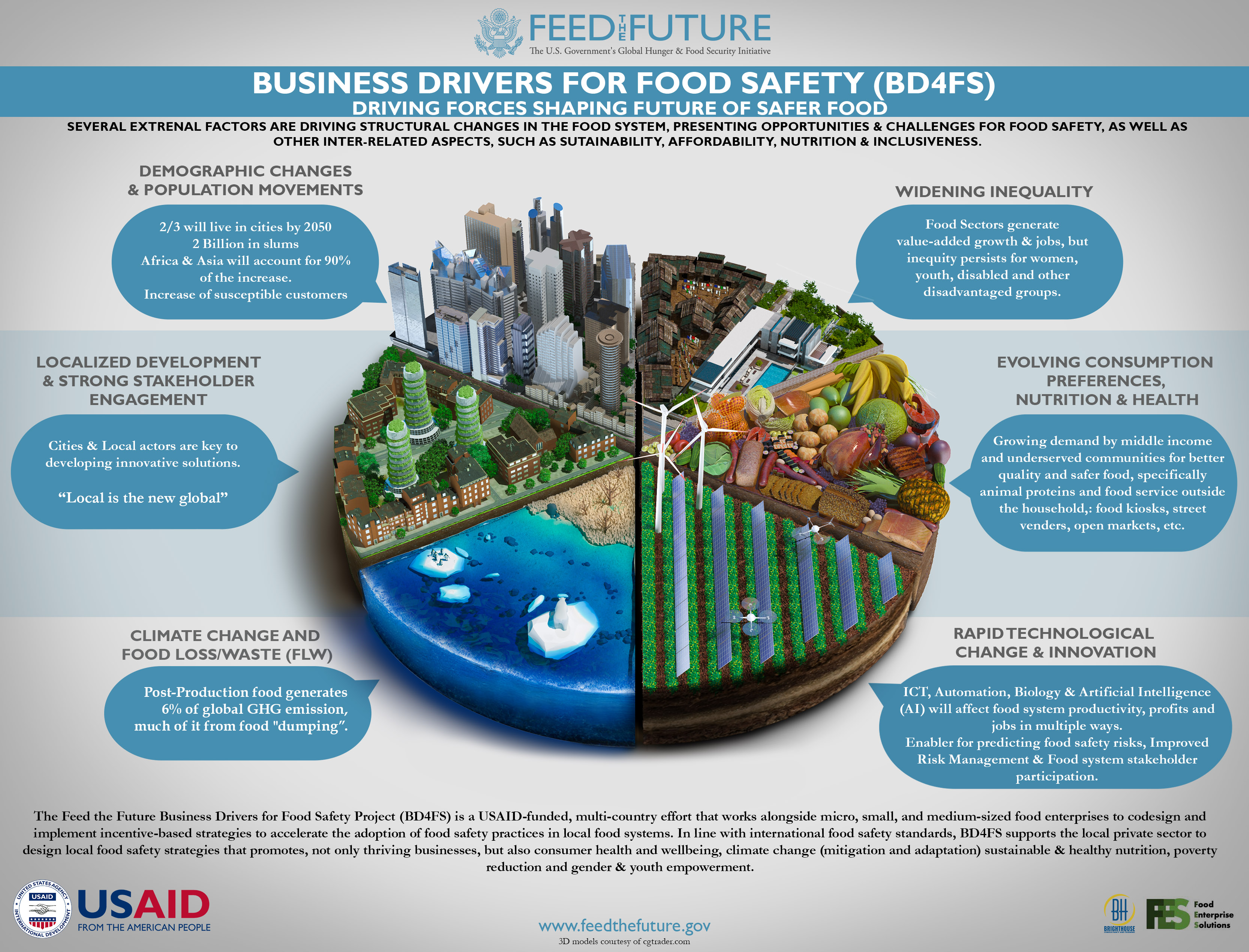
 View projectThis graphic was created to illustrate the driving forces that will shape the future of food systems in the developing world. Given the subject matter, I chose to illustrate each aspect as a pie...
 -
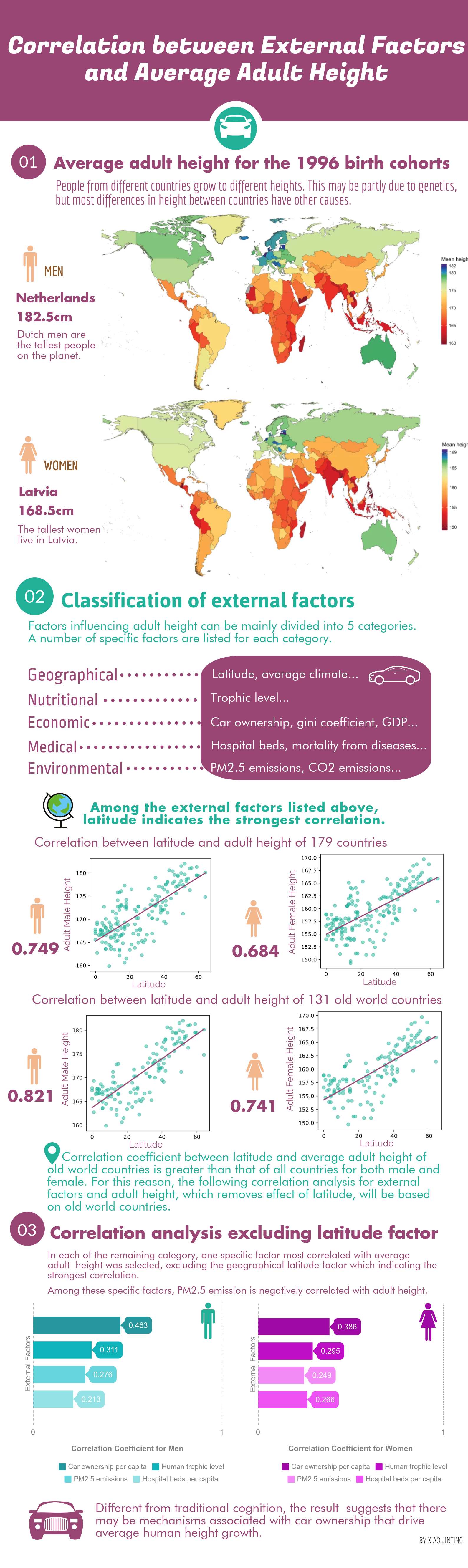
 View projectThe infographic shows that, after excluding the geographical latitude factor which indicated the strongest correlation, the most significant correlation was between per capita car ownership and...
 -
 View projectWebGL experiments 🔬 Video: https://youtu.be/afueyvwhvt4 Data: MapTiler #MaplibreGL #OSM #ThreeJS #WebGL #3D #maps #buildings #nyc #manhattan #maptheclouds #travel #cartography #arts...
 -
 View projectToronto-area schools provide vaccination rates for the Diphtheria-Tetanus-Pertussis (DTP) vaccine. The Toronto Public Health staff work with schools to show that students have either been...
 -
 View projectMeasurements are at the heart of analysis, testing, and discovery. Irish mathematical physicist Lord Kelvin once said, “When you can measure what you are speaking about, and express it in numbers,...
 -
 View projectThis infographic is targeted to kids, hoping to educate them using facts about the International Space Station.
 -
 View projectAn Infographic related to safety tips around mobile phone usage, with handy information pieces in three parts. The first part is dedicated to 10 short tips, such as: ‘What safety conditions do i...
 -
 View projectThis interactive map shows that central London is blanketed in air pollution that is above legal limits. The visualisation is based on new data from King's College London, combining air pollution...
 -
 View projectI love watching meteor showers and the magic that comes with them. While searching for more information on when to look at the sky to spot them, I came across a dataviz by Michela Lazzaroni...
 -
 View projectAll the main streets in (maybe) your city! Video: https://youtu.be/mSxhXsTijqE #QGIS #Threejs #WebGL #shaders #maps #harta #OpenSource #OSM #romania #3D #rute #routes #streets #strazi #city...
 -
 View projectThis infographic creates a narrative built out of qualitative data which maps India’s nuclear journey since colonial independence. The story outlines how a country marred by the pangs of separation...
 -
 View projectAn interactive essay that walks a reader through the process of building a histogram, from an unordered clump of values to the finished chart. The essay highlights how parameter choices throughout...
 -
 View projectThis was a data-driven explainer detailing what “psychobehavioral segmentation” is and how we can use this approach to drive vaccine uptake. Rather than just looking at demographics, the approach...
 -
 View projectThe first thousand days of a child are the most important to guarantee healthy development. IMAPI is a Nurturing Care Municipality Index that combines over 100 metrics that are strongly related to...
 -
 View projectHow do we begin to evaluate the impact of autonomous vehicles and shared mobility services on congestion? How do we embrace the uncertainty surrounding these new mobility technologies? Cities...
 -
 View projectThis work is a highly interactive exploration of the class of arachnids, based on the Data retrieved from the collaborative generalist database WikiData. The user can expand genders and sub-genders...
