
Humankind has been launching satellites and rockets into space for 60 years, filling Earth’s orbit with masses of debris with China’s expanding space programme a major contribution to the issue. An...
-
 View projectIndia has launched more than 90 spacecrafts since its maiden satellite launch Aryabhatta in 1975. The nation's space research activities are controlled by state-owned Indian Space Research...
 -
 View projectTo prevent climate change climate breakdown and keep global warming global heating below 3–4 degrees celsius, we have to reduce greenhouse gas emissions and transition to renewable energy –...
 -
 View project9/11 came as a gift to NSA, giving them more power and freedom to have mass surveillances illegally. And not just through eavesdropping on our phones, they’ve found a new weapon to invade our...
 -
 View projectDimensionality reduction is a powerful technique used by data scientists to look for hidden structure, producing visualizations that reveal patterns and clusters in data. Even though the data is...
 -
 View projectThe three infographics pages in the Annual Report of the Swiss National Science Foundation (SNSF) provide a vivid insight into the diverse funding activities of the Foundation in 2018: An overview...
 -
 View projectHow do we begin to evaluate the impact of autonomous vehicles and shared mobility services on congestion? How do we embrace the uncertainty surrounding these new mobility technologies? Cities...
 -
 View projectThe Journal plotted the location of every satellite currently in orbit, charting and color coding each by use and by country of origin, to illustrate the race to profit from space. This visually...
 -
 View projectThe goal of this project is to align the viewer’s choice of products and actions with their personal goals. There's so much unknown around ingredients used in our products, and this infographic is...
 -
 View projectHow is the world’s energy and electricity generated? What is the world’s largest power station? How does solar power compare to wind energy, geothermal energy or hydropower? How much of the world’s...
 -
 View project张衡早在东汉时期发明了地动仪,但由于历史的流失,地动仪只能通过科研人员逐步的根据历史记载复原,我希望更多的人们了解中国候风地动仪的文化。将时序性图表、空间关系性图表、分类关联性图表相结合,展现中外地震仪的发明,以东汉时期候风地动仪为主图,将其分解说明,将中外地震仪的发明进行对比,人们可以从这张图表中获得系统简洁易懂的地震仪文化,画面简洁现代。 Zhang heng, in the...
 -
 View projectIn 2013 Russian doctors teamed up with engineers to develop a robot‑assisted surgical system to meet the needs of both surgeons and patients. In 2018 first experimental surgery was successfully...
 -
 View projectEating a poor quality diet high in junk food is linked to a higher risk of obesity, depression, digestive issues, heart disease and stroke, type 2 diabetes, cancer, and early death. This...
 -
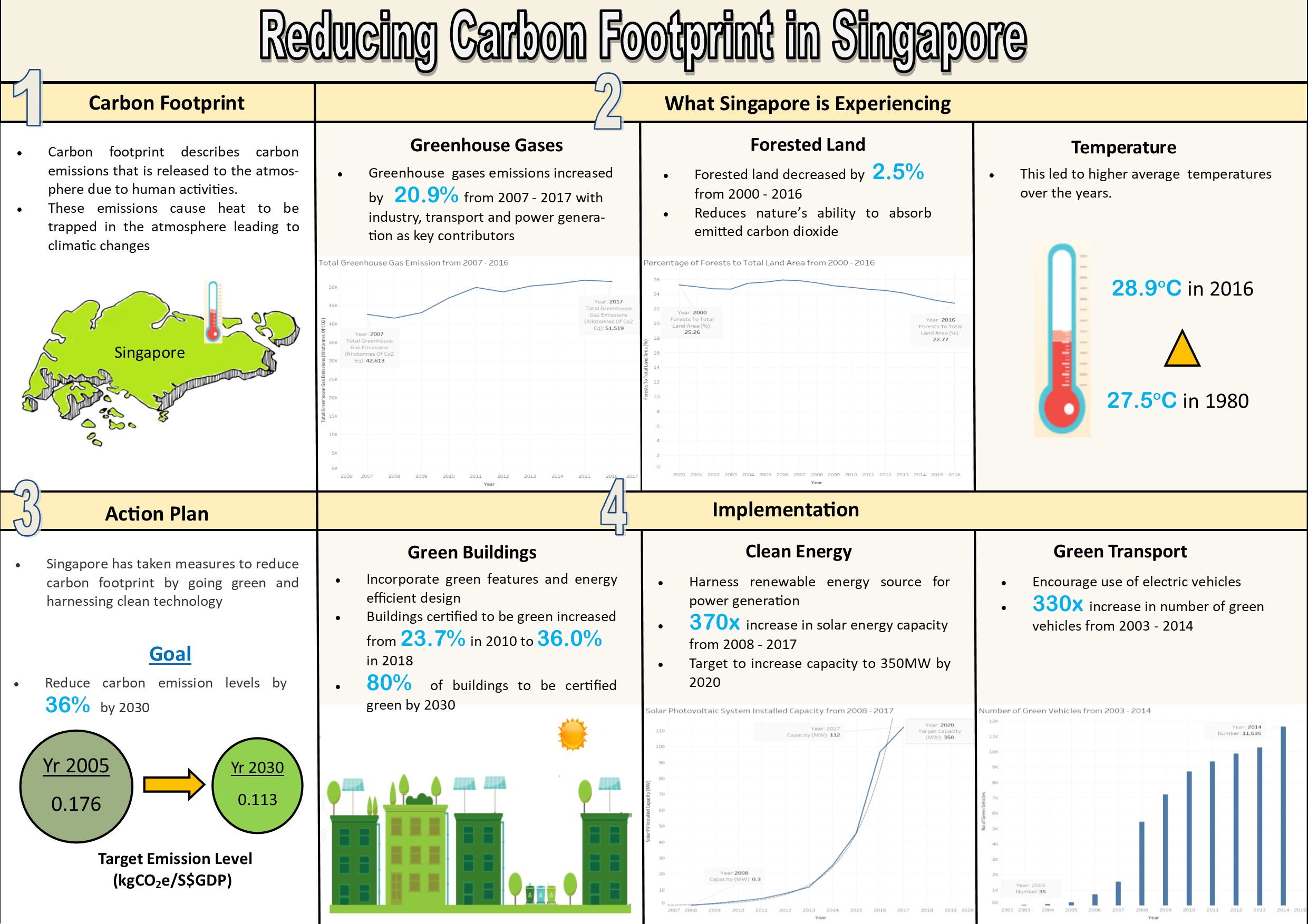
 View projectThe infographic shows the factors influencing carbon footprint in Singapore, its impact and the actions taken to reduce carbon footprint.
 -
 View projectThe phrase "health and longevity" is what everyone wants to achieve, and it is also a good wish for the other side. We can see in many TV programs that some people do everything they can to live a...
 -
 View projectThis story explains how and why hunching over your phone is destroying your posture and exposing those around you to manifold dangers. Data, diagrams, videos and animation show how and why we get...
 -
 View projectStorytelling In a world of global competition, startup ecosystems and their innovators need to build their ventures based upon their core strengths. The depicted comparison of Europe and China not...
 -
 View projectSilicon-based civilization is already integrated into people's lives. Carbon-based civilization is the culture formed by organisms, while silicon-based civilization is driven mainly by data, which...
 -
 View projectGlobal air pollution is getting worse and worse. This chart can help everyone better understand the types and components of pollutants in the atmosphere.
 -
 View projectHow much of an increase in temperatures in Spain because of climate change? I analysed the temperatures increase in 47 stations of AEMET(State Meteorological Agency in Spain). The data came...
 -
 View projectScientists have launched a new project to explore the effects of climate change by looking at a little known part of the ocean.
 -
 View projectThe main visual interface for threaded conversations on the internet (forums) is still mostly text. In this work we give a full reimagining of the forum reading experience through the use of graph...
 -
 View projectThere's a good chance you experienced an earthquake today. Every day there are hundreds of thousands of earthquakes all over the world, except most are so small they are never felt. But what...
 -
 View projectThe Astronomical Hijri Calendar is an attempt at combining both science and religion by weaving it through the representation of time. The calendar puts together the Hijri dates on the Gregorian...
 -
 View projectThe European Union Emissions Trading System (EU ETS) is one of the EU's cornerstones in its strategy for cutting emissions of manmade carbon dioxide (CO2). This visual piece explores how it works...
 -
 View projectAdrift is an online Citizen Science project that enables participants to visualise the environmental conditions experienced by microscopic marine microbes as they are propelled around the globe by...
 -
 View projectThe GROW Observatory is a European-wide project engaging thousands of growers, scientists and others passionate about the land. For the Soil Moisture Maps project, we use local sensor and satellite...
 -
 View projectThe soil of Korea is severely polluted. The Korea soil pollution campaign has utilized infographics to visually analyze the data collected through the Soil Measurement Network provided by the...
 -
 View projectHow can we measure the impact of the most important scientists on our society? Many factors can be considered: industrial applications, scientific prizes, etc. One of them is the analysis of their...
 -
 View projectWe built an interactive map to look at the various ways that the UK sources its energy. It’s a broad subject with an elaborate system of connecting parts, but the majority of people understandably...