
This graphic is a visualization of the history of US state boundaries. It gives an overview of current and past state boundaries throughout the country's entire history, combining time and space in...
-
 View projectThis visualization presents an aesthetic and holistic way of viewing local climate patterns and the relationships between various weather parameters. Playing with the Wikipedia common...
 -
 View projectThe complete story of the FiFa World Cup, beginning with the first edition of 1930 in Uruguay until the last of 2010 in South Africa. The analyzed data are used to display the goals scored, the...
 -
 View projectAs climate change alters habitats and disrupts ecosystems, where will animals move to survive? And will human development prevent them from getting there? This map shows the average...
 -
 View projectVisualizing the loneliest islands in the world by ranking their loneliness through a scoring system of four factors: number of inhabitants, overall land area, proximity to other land and that...
 -
 View projectTwenty-four solar terms is according to the sun in the ecliptic (the earth's orbit around the sun) on the position of the change and develop. Twenty-four solar terms can reflect the change of...
 -
 View projectThis diagram portrays China's social media platforms in 4 categories, based on stage of maturity and functional dependency.
 -
 View projectChina's imports overall are down by 14.6% over 2015. Find out what happens if this decline continues for the rest of the year - or worsens - and how that loss compares to each country's...
 -
 View projectVisualising the National Football Soccer League of Costa Rica for the Summer Tournament 2015. The 12 First Division clubs had varied objectives: win the title, make decent progress or simply avoid...
 -
 View projectA large-format educational poster, this timescape traces the history of graphic design in the twentieth century. It is a presentation of major design movements emerging out of western Modernism...
 -
 View projectStadtbilder is an attempt to map the digital shape of cities. While traditional maps show us buildings, roads and physical infrastructure, these maps reveal where and in which form the city is...
 -
 View projectThis piece was originally created as a 40th birthday gift for a friend who loves baking. I loved the idea of giving her a playful piece of art she could hang in her kitchen. I created all edible...
 -
 View projectDue to its popularity and to its policy that allows anyone to edit pages, Wikipedia often becomes a battlefield, where different factions try to impose their view on controversial topics...
 -
 View projectArtwork for Il Corriere della Sera - La Lettura about the Roman emperors (from Augustus to the last of the Western Roman Empire) , their causes of death and their years in power Source: Wikipedia
 -
 View projectTurns out great minds don’t think alike. Discover how some of the world’s most original artists, writers and musicians structured their day, based on ‘Daily Rituals’ by Mason Currey. Filter the...
 -
 View projectThis visualisation charts Post Office data comparing various holidays costs in different countries from around the world.
 -
 View projectThis visualization explores the story of Nobel prizes through years. Visualized for each laureate are prize category, year the prize was awarded, and age of the recipient at the time, as well as...
 -
 View projectThe number of infected people, measured over 70-some years and across all 50 states and the District of Columbia, generally declined after vaccines were introduced. The heat maps below show number...
 -
 View projectVisualisation of all fallen and found meteorites between 1900 & 2000. The graphic gives a special view on meteorite findings by comparing time and longitude on a radial axis. This kind of...
 -
 View projectWe worked with the Iran Media Program to map a complex constellation of leaders and governing bodies involved in Internet censorship in Iran. It visualizes the relationships between different...
 -
 View projectThe physical charts are an attempt to make data and data visualisations legible to ordinary people in their daily lives. In response to the increasing sophistication of data visualisations and the...
 -
 View projectFlags are arranged by the most common combinations of colors. Colors and combinations are arranged in a spectrum-like order: red, orange, yellow, green, and blue, with black and white at the...
 -
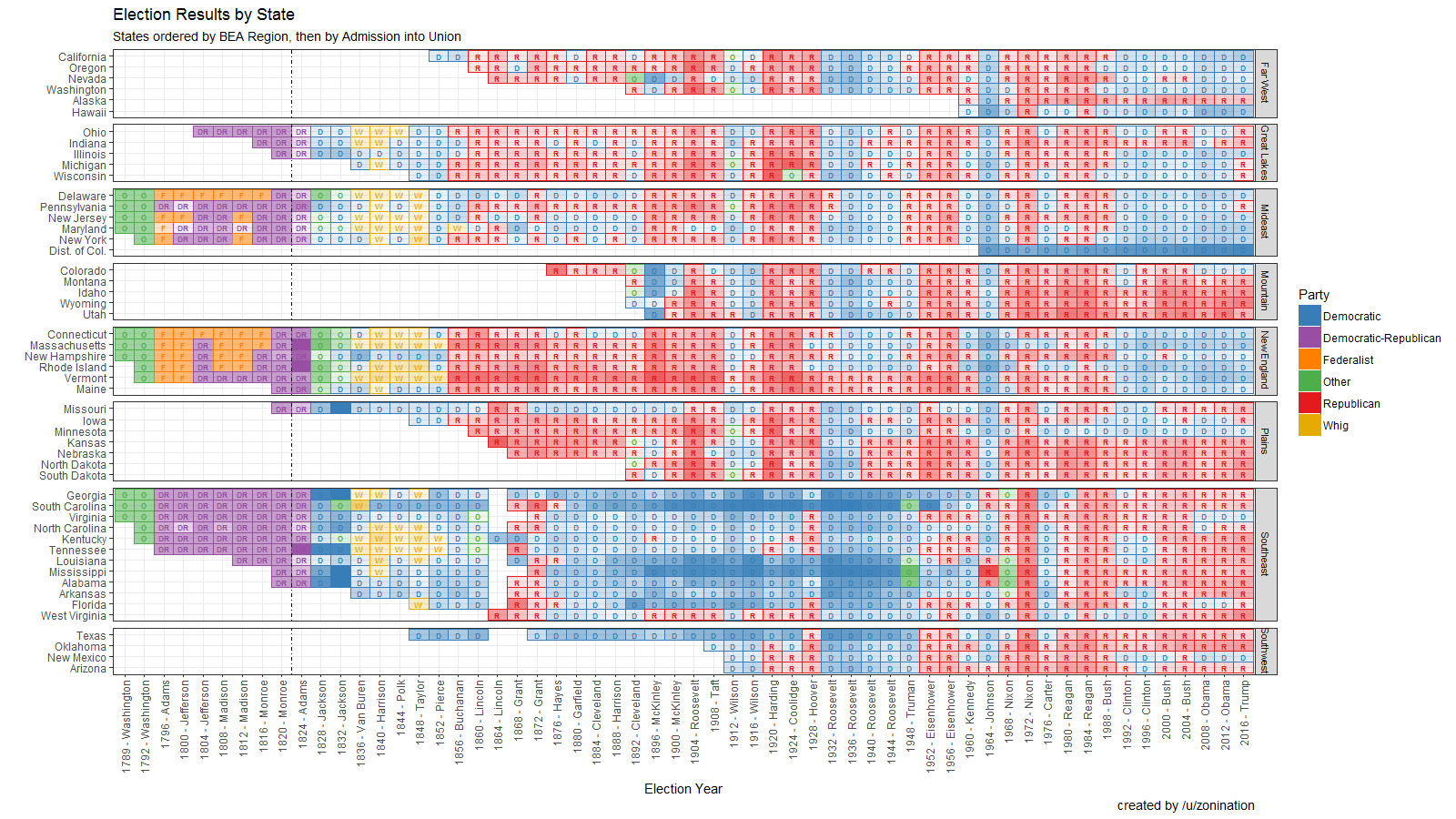
 View projectOpen Source visualization of Election Results by state, party, year, and candidate, sorted by region.
 -
 View projectDouble pages for Wired about the italian public health according the death rate in the hospital per disease. The visualization shows the main killers and the five best and five worst hospital...
 -
 View projectMonitoring poverty and well-being in NYC in this interactive for the Columbia Population Research Center.


