
Based on the new trend of information visualization as the dissemination of the information age, this work takes the "Splendid Xilan" visualization website as the theme, constructs five main...
-
 View projectChina's property market has faced challenges since the second half of 2021, including developer defaults, downgrades, maturing debts, Covid lockdowns, and mortgage boycotts. The property sector is...
 -
 View projectThe Tour de France is a very tough sporting event, possibly to toughest in the world - but which year was the toughest race? I've broken out factors that affect how challenging the competition and...
 -
 View projectA data visualisation outlining the volume of air pollutants pumped out in Europe through industrial activities (e.g., burning fossil fuels, raising livestock etc.) and their relative scale and...
 -
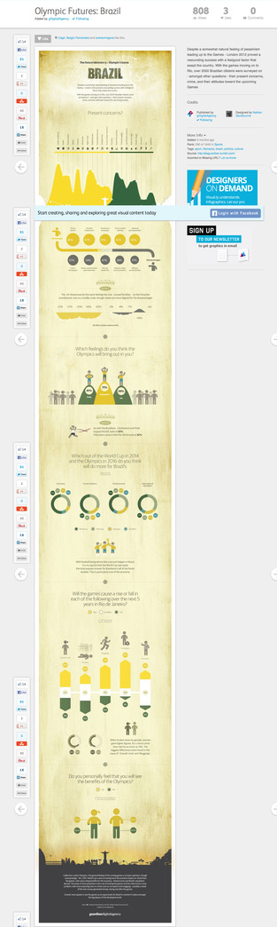 View projectThis work was an attempt to bring the somewhat perceived enthusiasm with a smatter Brazilian vibrancy and place it against the well known problems and tensions of everyday life. Setting this in the...
 -
 View projectThis infographic compares the cost of living to purchase power in each state. There are countries, like India, where prices are low and purchasing power is well above average. One explanation here...
 -
 View projectGermany would have made the cut, Australia would have topped its group and Argentina would be on their way home – using expected goals, we calculated what the knockout stages of the 2018 football...
 -
 View projectThe Delayed Gratification team (www.slow-journalism.com) loves to dive into sports data, and for our book An Answer For Everything we thought it would be fascinating to see how much athletes have...
 -
 View projectThe Colorado River — the most important water source for 40 million people in the West — is draining. For a century, seven states engineered ways to wring ever more water from the river, defying...
 -
 View projectThe food industry profits from providing poor quality foods, with poor nutritional value, that people eat a lot of. Thankfully we have The Michelin Guide | Main Countries of Europe...
 -
 View projectThis visualization traces the musical lineage of over 10,000 artists to just 8 "originals". Starting with the most influential artist in 8 different genres (based on the number of artists that they...
 -
 View projectNanjing, an important birthplace of Chinese civilization, has the titles of "Ancient Capital of Six Dynasties" and "Metropolis of Ten Dynasties". It has a special status and value in Chinese...
 -
 View projectMy goal is to explore new experiences around data consumption beyond the written and visual forms by taking advantage of music's temporal nature and capacity to alter one's mood. Topics will...
 -
 View projectThis visualization was created as part of the Viz4ClimateAction initiative hosted by Tableau and TheSDGVizProject. It features 4 different visuals that walk users through the story of climate...
 -
 View projectThe past week of Trump scandals for people reading mainstream news outlets has gone something like this: President Trump fired the FBI director who was investigating his campaign’s connection with...
 -
 View project"Charting Paths to a Women's Majority," developed by Graphicacy for Vote Run Lead (VRL), visualizes strategies for achieving women's majority in state legislatures. With women currently comprising...
 -
 View projectThe spells of Dungeons & Dragons are fictional magic spells used in the settings of the role-playing game, Dungeons & Dragons (D&D). The casting of spells within Dungeons & Dragons...
 -
 View projectThis visualisation aims to highlight the impact of the non-profit, Build Up Nepal, by raising awareness surrounding the existing problem Nepal faces and concluded with a call-to-action. Build up...
 -
 View projectUn recorrido por la trayectoria del basquetbolista que empezó su andar como “el próximo Michael Jordan” y la terminó como el “auténtico Kobe Bryant”.
 -
 View projectThe joys of the airport: Late or canceled flights. Long lines. Crowded terminals. Overpriced, appalling food. Bloomberg Businessweek surveyed more than 3,000 frequent flyers, analyzed travel...
 -
 View projectThe visualization shows the collection of historical drawings by Frederick William IV alongside a thematic and temporal arrangement. The aim was to highlight thematic and historical connections...
 -
 View projectThis project is the work of a volunteer for the Archipelagos Institute of Marine Conservation, an NGO based in Greece. Working with raw data with the intent of providing the organisation with a...
 -
 View projectWomen, Money, & Politics Watch 2024 is a dynamic data visualization platform created by Graphicacy for The Center for American Women and Politics (CAWP) to track campaign financing during the...
 -
 View projectThe world's best infographics and data visualizations showcased, from the makers on Infogr.am. Infogram | Visualoop
 -
 View projectNorman Greenbaum's "Spirit in the Sky" has been played over 68,000,000 times, and makes up 99.5% of plays from his top 5 songs on Spotify.
 -
 View projectThis visualization explores the rapid growth and competitive landscape of large language models (LLMs), a cornerstone of artificial intelligence, from 2018 to 2024. It highlights the key players,...
 -
 View projectMany of us routinely force our bodies to fight sleep. We drink caffeinated beverages by day to stay alert and alcohol to wind down at night. Some of us work all night and sleep in daylight. Others...
 -
 View projectSince 2014 The Visual Agency has worked with Brembo, a global leader in the design, development and production of braking systems, to help them tell the story of their involvement in the F1,...
 -
 View projectThis infographic offers an in-depth look at the state of global fishing. It compares the most used fishing techniques and their impact, the most fished species and their provenance, the global...
 -
 View projectThis research facilitates the understanding of each node’s features through Heatmap visualization in creating network visualization, and suggests a clustering of nodes by connecting the sentiment...