
“Data” has penetrated into every industry and business function area today and has become an important production factor. And we can easily find that in this era of big data, no matter what we want...
-
 View projectThis project is an interactive website illustrating the dynamics of Shenzhen through data analysis on 165 metro station areas. With this metro searching tool, the readers can have a better idea of...
 -
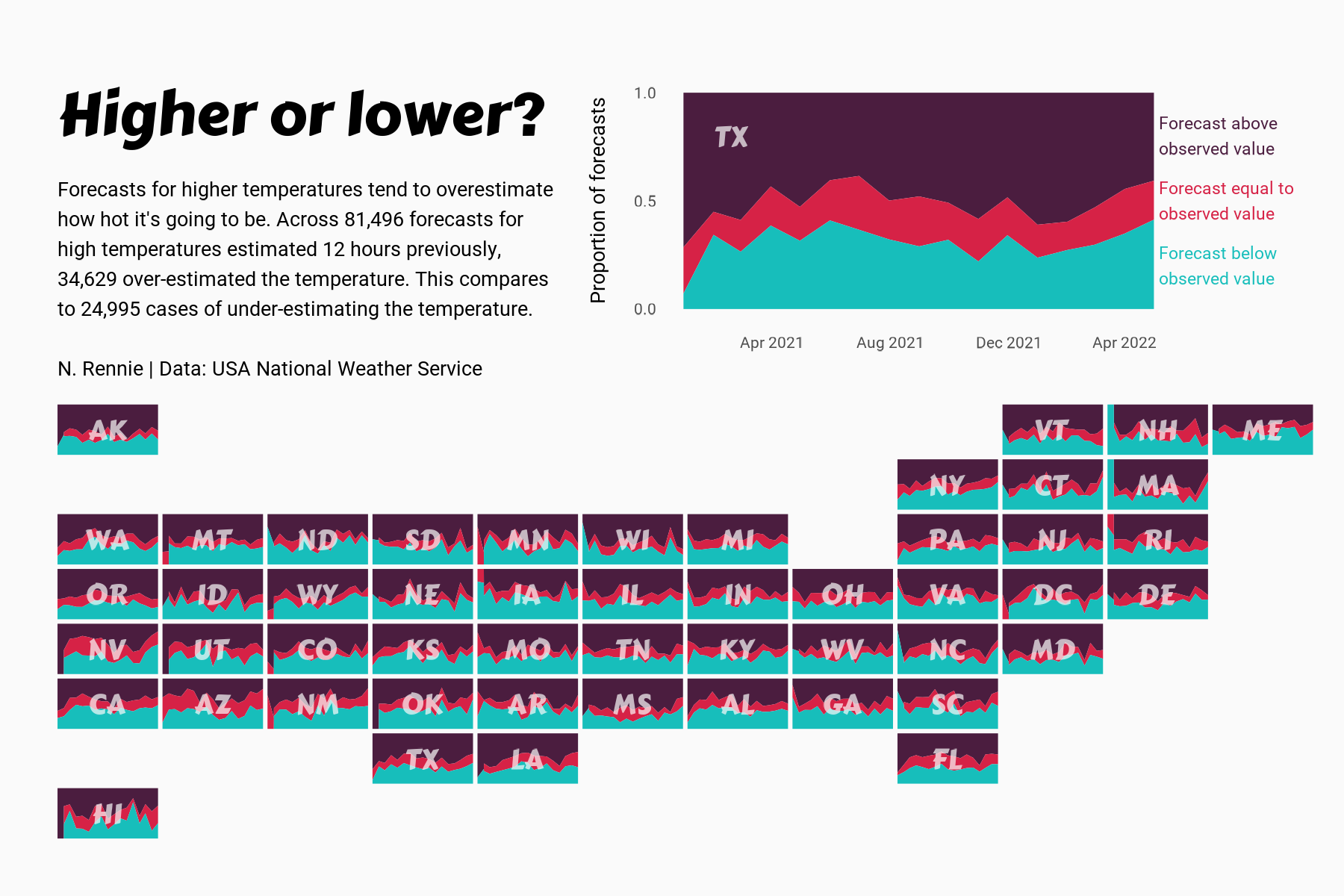
 View projectThis chart visualises the accuracy of high temperature forecasts made by the USA National Weather Service between January 2021 and June 2022, within a 12 hour window. Proportional area charts show...
 -
 View projectThis story was born from an aesthetics decision. After a night playing old soccer video-games, I thought it would be cool to make a story about the FIFA World Cup using design elements that...
 -
 View projectTheMathCompany empowers organizations with expert intelligence, solving complex business problems through simple, human-centric, and scalable solutions at speed. With people at the heart of...
 -
 View projectIn the wake of the two years of protests in Hong Kong, the South China Morning Post’s city desk and infographics team decided to showcase 173 prominent leaders, including 108 district councillors...
 -
 View projectA good visualization engages a user and answers their questions. In this case, the question is “What should I drink tonight?!” Let’s say you have gin and lime sitting on your shelves. By selecting...
 -
 View projectIn this project, I researched the origins of 900-odd Portland, Oregon street names to see who we've named streets after. Shockingly, a just 6 streets are named after people of color, only one of...
 -
 View projectThis application generates a random medieval city layout of a requested size. The generation method is rather arbitrary, the goal is to produce a nice looking map, not an accurate model of a city....
 -
 View projectWe commemorate the late, great Philip Seymour Hoffman, tracking his complete silver screen career.
 -
 View project629,000 girls (aged 0–6 years) are estimated to be missing in India every year. The majority of them are aborted, others are killed, abandoned or neglected to death just because they are girls....
 -
 View projectMetroverse is an urban economy navigator built at the Growth Lab at Harvard University. It is based on over a decade of research on how economies grow and diversify and offers a detailed look into...
 -
 View projectInspired by the movie "Moneyball," I wanted to use analytics and visualization to get faster at completing the sudoku. For this project, I created a browser extension to track my moves as I...
 -
 View projectEvery day, 91 people overdose on opioids in the United States. Opioid addiction has become an epidemic. Why is it such a big problem? And what can we do to help? In this animation, a...
 -
 View projectWashington state has a rainy reputation. But let's put that to the test. This visualization uses precipitation data from over 100 weather collection stations for the year 2020 (~30k points), which...
 -
 View projectThe Department of Energy & Climate Change asked TNS to produce an informative infographic based on consumer attitudes towards energy usage and the impact this has on the environment. This...
 -
 View projectStudents visit the medical room but do not get the medicine's they need and have to walk for almost 2km to get there medicine.
 -
 View projectThe ‘BFI Filmography’ is a collection of over 10,000 film titles condensed into one dashboard of interactive data visualisations. Launched in September 2017, it is the largest public searchable...
 -
 View projectThe first part of this visualization is the interactive map: With the green arrows, you can choose a governance indicator and see which countries have te highest or lowest indicator.A country which...
 -
 View projectBeer is the most popular drink in Brazil. Its importance has grown more and more in the past few years and there has been a boom of new craft and industrial labels. This growing plurality...
 -
 View projectFor Bauhaus-Universität Weimar' startup and founder support network "neudeli" I created an explanatory poster describing the parts and the use of the Prusa 3d printer i3 MK3S+. Main part of the...
 -
 View projectThis interactive globe shows the geology of Earth over the past 750 million years. Users can enter their locations to see where their homes are on the Pangaea supercontinent and other unique...
 -
 View projectWith this real-time data visualization project I try to address one of the hottest topics in today's Italian politics: is it true that Matteo Salvini (deputy PM and Minister of Internal Affairs)...
 -
View projectSummer days at Chavez Ravine can be punishingly hot. But if you choose your seat wisely, you can enjoy a michelada in the shade all season long.
-
 View projectEniday is an Eni’s project, a digital magazine focused on innovation and storytelling, providing explainations and stories on how natural resources are transformed into energy. The Visual Agency...
 -
 View projectAn animated visualization of commuting patterns for US counties operating at the US Census Tract level. Tract to tract flows are shown based on user selected criteria.
 -
 View projectIn celebration of 100 years of bird banding, Scientific American (Jen Christiansen) commissioned me to create a visualization for the March 2021 edition. The Bird Banding Laboratory has been...
 -
 View projectThe editorial project is focused on Valpolicella, an area situated in Verona province. The purpose is to explore the use of narrative maps as a tool for transmitting spatial information. The aim...

