
Dimensionality reduction is a powerful technique used by data scientists to look for hidden structure, producing visualizations that reveal patterns and clusters in data. Even though the data is...
-
 View projectWhy did human development proceed at such different rates on various continents? I used the data and the theory presented by Jared Diamond to make this project to let people easily know his...
 -
 View projectThe interactive digital special project "Mercator. It’s a Flat, Flat World" tells the story of a famous map, published in 1569 by the Flemish cartographer Gerardus Mercator. We describe the...
 -
 View projectThis infographic was a class project from my spring 2019 "Information Design" course. The project started with 'mind-mapping' on the topic of waste. I found myself feeling passionate about...
 -
 View projectAn interactive visualisation of weather data, on a multitouch display whith haptic control elements. In this project a visualisation was created that emphasises on the cyclic nature of weather...
 -
 View projectThe Strait of Hormuz is the highway for nearly a fifth of the world’s oil. But it’s located in the volatile region of the Middle East. Subsequently tankers using the route have been attacked, most...
 -
 View projectAnaptár is a unique, informative poster calendar, which is a source of fascinating new discoveries. It provides lots of information beside enumerating days: visualizing data on the Sun and the Moon...
 -
 View projectIn 2012, fourteen buildings on Beijing's central axis were included in China's preliminary list of world heritage sites. As the historical and cultural buildings of the ancient capital of the six...
 -
 View projectComparing Jordan and Bryant's data performance in all aspects, including champions, points, shot accuracy, and MVPs, the goal of this infographic is to see who is the best basketball player in NBA...
 -
 View project"Leaves" is a course assignment of information chart design in the junior year. I collected and summarized the information, and elaborated it in seven aspects, including definition, composition,...
 -
 View projectThis map visualizes the orbits of more than 18000 asteroids in the solar system. This includes everything we know of that’s over 10km in diameter - about 10000 asteroids - as well as 8000...
 -
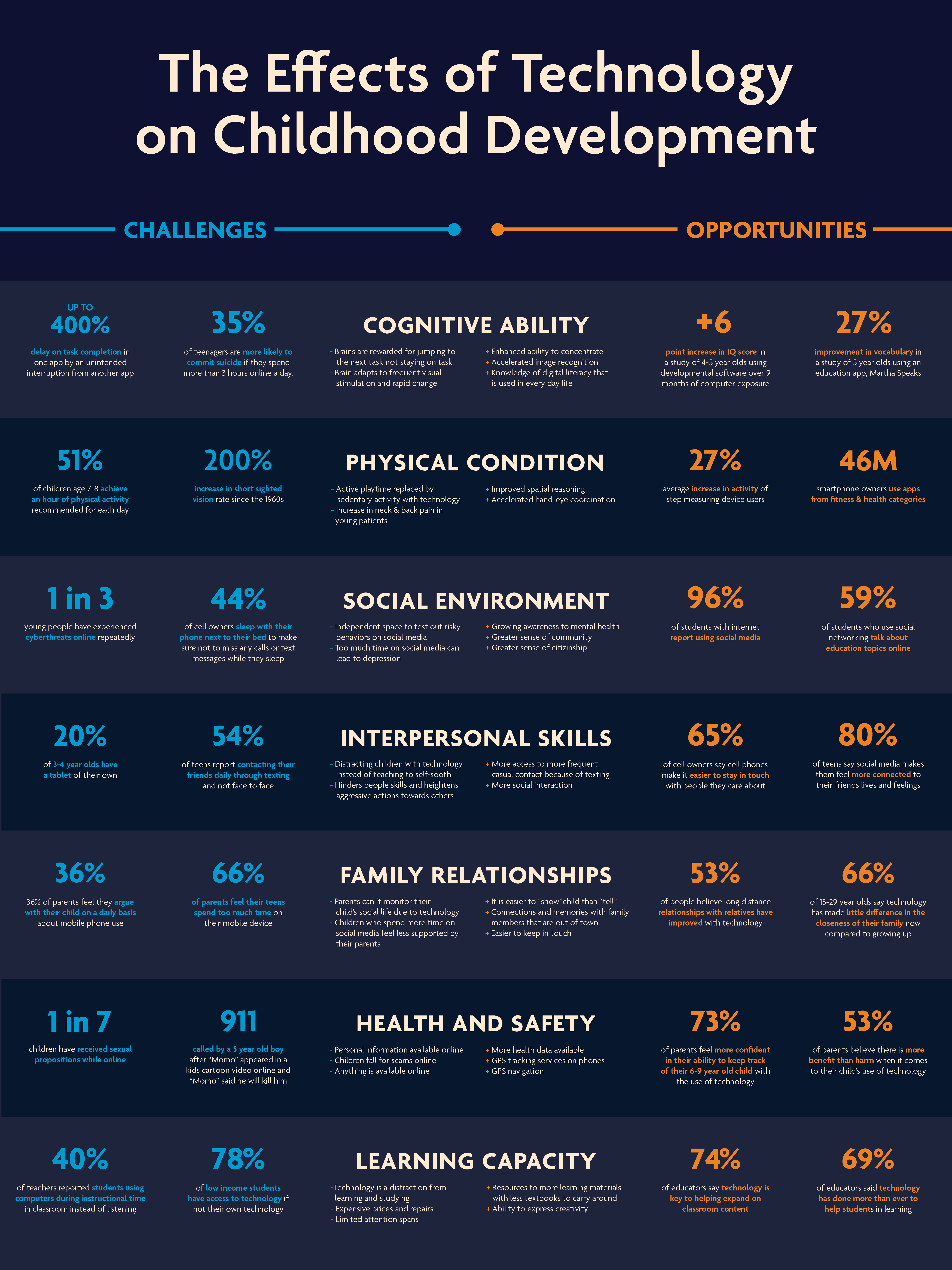
 View projectThis topic is very important to me because my younger sister is 15 years old and technology is a huge part of her life right now. My mom grew up without technology, so they have a big difference in...
 -
 View projectWide-ranging applications of data science bring utopian proposals of a world free from bias, but in reality, machine learning models reproduce the inequalities that shape the data they’re fed. Can...
 -
 View projectSometimes we have to challenge readers' sensibility so we can build a better world. This cut-out infographic includes a mid-upper-arm circumference (or MUAC) bracelet, which is used to help assess...
 -
 View projectThe Royal Dutch Cycling Federation wanted to attract more people to the fascinating sport of Freestyle BMX. Targeting live spectators and jury members, we developed an engaging platform that...
 -
 View projectThe US government can collect massive amounts of data on individuals through top secret surveillance programs. The more you rely on digital tools in your daily lives, the more intelligence agencies...
 -
 View projectIn collaboration with OECD, we created an interactive data platform to help countries assess their state of digital development and formulate policy strategies in response. The toolkit supports the...
 -
 View projectThe work integrates the questions related to the game and people's psychology through questionnaires in the way of investigation, and finally presents them through dynamic posters and interactive...
 -
 View projectThe western winds and the North-Atlantic ocean current make the European winter a relatively mild one, but this season still comes in many different shapes accross the continent. Explore them all...
 -
 View projectFor the 2018 Brazilian general elections, our team developed a highly detailed results map, segmenting the electoral results by ballot location. This may seem trivial in countries where the state...
 -
 View projectJPEG images are everywhere in our digital lives, powered by algorithms that remove details that are imperceptible to the human eye. This produces the highest visual quality with the smallest file...
 -
 View projectVisualization of the first Russian victimization survey. An overall view of what happens after a crime is committed, cybercrime in comparison with other types of crime and some circumstances of...
 -
 View projectConsumer goods prices are normally used to compare cost of living across countries. It’s seldom considered that many essential goods and services we rely on throughout our lives are provided free...
 -
 View projectCitygraph is a chart to visualize and analyze urban structure. It is a based on 3D model of a city. All buildings have exaggerated heights and shifted on map to a 10-kilometer zone (to reduce...
 -
 View projectThis visualization explores the messages we’ve beamed into the cosmos over the last sixty years. Some are serious scientific endeavours, others less so. Together they represent a time capsule of...
 -
 View projectThis unique interactive map allows you to explore and compare fields and crops in Europe and the USA. The entrant has supplied multiple files for this work: [1] [2]
 -
 View projectBauhaus was the first college in the world to be founded entirely for the development of modern design education. It was founded in 1919 by German architect Walter Gropius. The establishment of...
 -
 View projectThis interactive visualisation is about Italo Calvino, one of the most well-known and studied writers in contemporary Italian literature. The visualisation depicts the corpus of author's literary...
 -
 View projectSince 1980, there have been 101 mass shootings in the United States in which four or more victims were killed, most recently on August 31, 2019 in Odessa, TX, where 7 people died. As painful as it...
