
This poster explores the disciplines or professions of creators and theorists who marked the history of data visualization. In the 18th and 19th century, visualizing data is used for thinking...
-
 View projectThis infography is based on the popular board game of Chutes and Ladders. The game consists in navigating one's game piece, according to die rolls, from the start (bottom square) to the finish...
 -
 View projectThis visualisation looks at the housing cost (buying and renting) in the London Boroughs over a period of four years.
 -
 View projectHealthcare failures place an extra burden of care on transgender people and their families, and can stop them being economically active. Here is what health care providers and legal services can do.
 -
 View projectThe artwork represents the revenues of all Star Wars episodes (in the middle), and their actors (outer circle), according both to all the films they took part in and to only those of the saga....
 -
 View projectShipmap.org is an ambitious interactive WebGL map of commercial shipping movements based on hundreds of millions of data points from throughout 2012 (the most recent year for which all the raw...
 -
 View projectThese are two infographics. One shows that Google representatives attended White House meetings more than once a week, on average, from the beginning of Obama’s presidency through October 2015. The...
 -
 View projectThe book “The Atlas of Gentrification” is a collection of data visualizations, graphs and maps which respond to the phenomenon of gentrification and related issues, such as segregation and income...
 -
 View projectThe purpose of this project is to represent and explain data quickly and effectively in a visual and interactive way that represents and tells a story about one particular aspect of Johannesburg....
 -
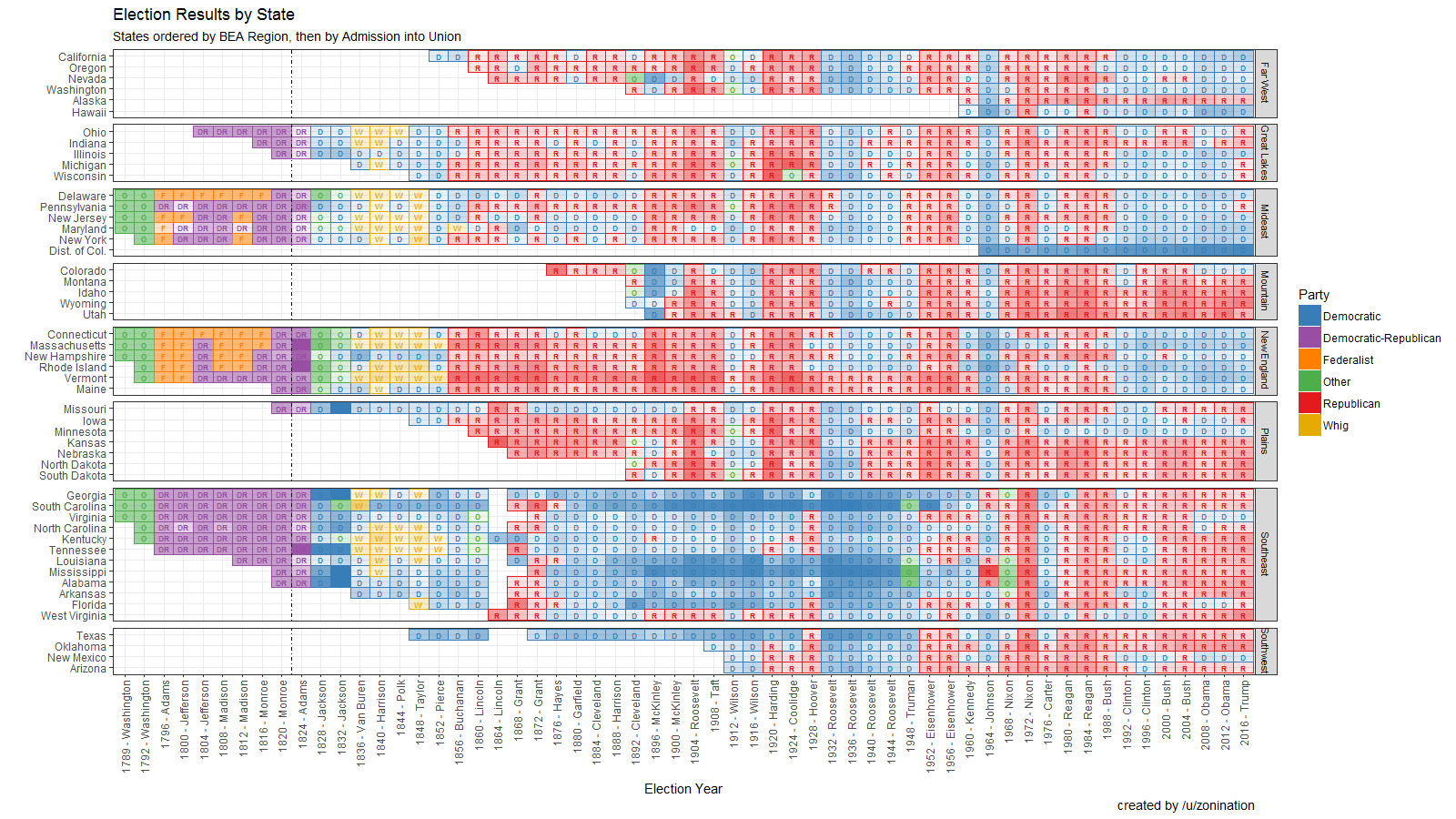
 View projectOpen Source visualization of Election Results by state, party, year, and candidate, sorted by region.
 -
 View projectPeople travel not just more frequently, but increasingly far and quickly. Mapping the connections between all the airports worldwide is a fascinating network visualization exercise. A network, in...
 -
 View projectdelvv.io would like to submit the graphic work from our very own Rising Star, Anja Laubsher. We are a qualitative research startup based out of Johannesburg, South Africa. We live in a continent...
 -
 View projectEach number capable of factorization (2–101) is factorized to its primes. Each prime factor is represented by a ring of "leaves" around a center point colored with a light-to-dark gradient....
 -
 View projectUn recorrido por la trayectoria del basquetbolista que empezó su andar como “el próximo Michael Jordan” y la terminó como el “auténtico Kobe Bryant”.
 -
 View projectSince the retirement of Nasa’s Space Shuttle in 2011, Soyuz has been the sole means of transportation of crew members to the International Space Station to this day (2016). This graphic attempts to...
 -
 View projectArtwork for BBC Focus Magazine regarding climate change due to different causes from 1880 to date Source: Nasa
 -
 View projectAwardPuzzle is an interactive data visualization online platform for award-winning tips of China National Exhibition of Fine Arts, and it is also a method to understand current ideology of China....
 -
 View projectVanuatu is the riskiest country to live in, with natural disasters on average affecting more than a third of the population each year, according to the World Risk Report 2015. Countries are...
 -
 View projectWith the ‘Cymascope,’ sound can be transformed into an image to visualise the sound of birds like the forest, developing a method for translating the frequency of bird calls into...
 -
 View projectWe have become the largest producers of data in history. Almost every click online, each swipe on our tablets and each tap on our smartphone produces a data point in a virtual repository. According...
 -
 View projectAround 1.9 million people work in creative occupations across the UK, which is approximately 6% of total employment. But where do these creatives live? And do some areas of the UK have a higher...
 -
 View projectAn historical overview on the visualization of data and information. Visualization is a language that could be defined as almost universal, something that makes it possible to translate data and...
 -
 View projectCall it taxonomy, classification, even organization — it is what we use to make sense of almost everything around us. We put things in logical, labeled boxes that help us comprehend the world. The...
 -
 View projectGalileo's Impact On Modern Science According to Stephen Hawking, Galileo probably bears more of the responsibility for the birth of modern science than anybody else, and Albert Einstein called...
 -
 View projectDress For Our Time, by award-winning artist and designer Helen Storey MBE RDI (London College of Fashion, UAL Centre for Sustainable Fashion) and creative agency Holition is a unique installation...


