
Designing a lab for synthesis and handling of highly toxic chemicals.
-
 View projectIllustration of 102 significant volcanic eruptions of last 18 years based on dataset by National Centers for Environmental Information (https://www.ngdc.noaa.gov/hazard/volcano.shtml)....
 -
 View projectTransitioning from fossil fuels to renewable sources of energy is a key step in reducing greenhouse gas emissions and addressing climate change. Acknowledging this, a growing number of companies...
 -
 View projectFor the French health insurance organization, Wedodata has created a complete interactive dashboard that offers an overview of the pathologies of French people over 5 years. For the first time,...
 -
View projectWith the evolution of technology, scientific knowledge, which used to be understood only by scientists, started to be transmitted to the general public through physical or digital artefacts...
-
 View projectA VR app for laymen and astronomers that visualizes X-ray data of astronomical objects from the ESA satellite XMM-Newton. Data of >1,000 X-ray sources generate unique data objects. Their sizes,...
 -
 View projectA look at the change in the amount of sea ice in the Arctic over the last four decades. In reviewing the data, it struck me that I could convey the numbers in an arctic aesthetic, allowing the...
 -
 View projectThe "Biodiversity" project is based on a study by the Leopoldina Academy on the connection between species extinction and agriculture. The particular challenge was to put this extensive study into...
 -
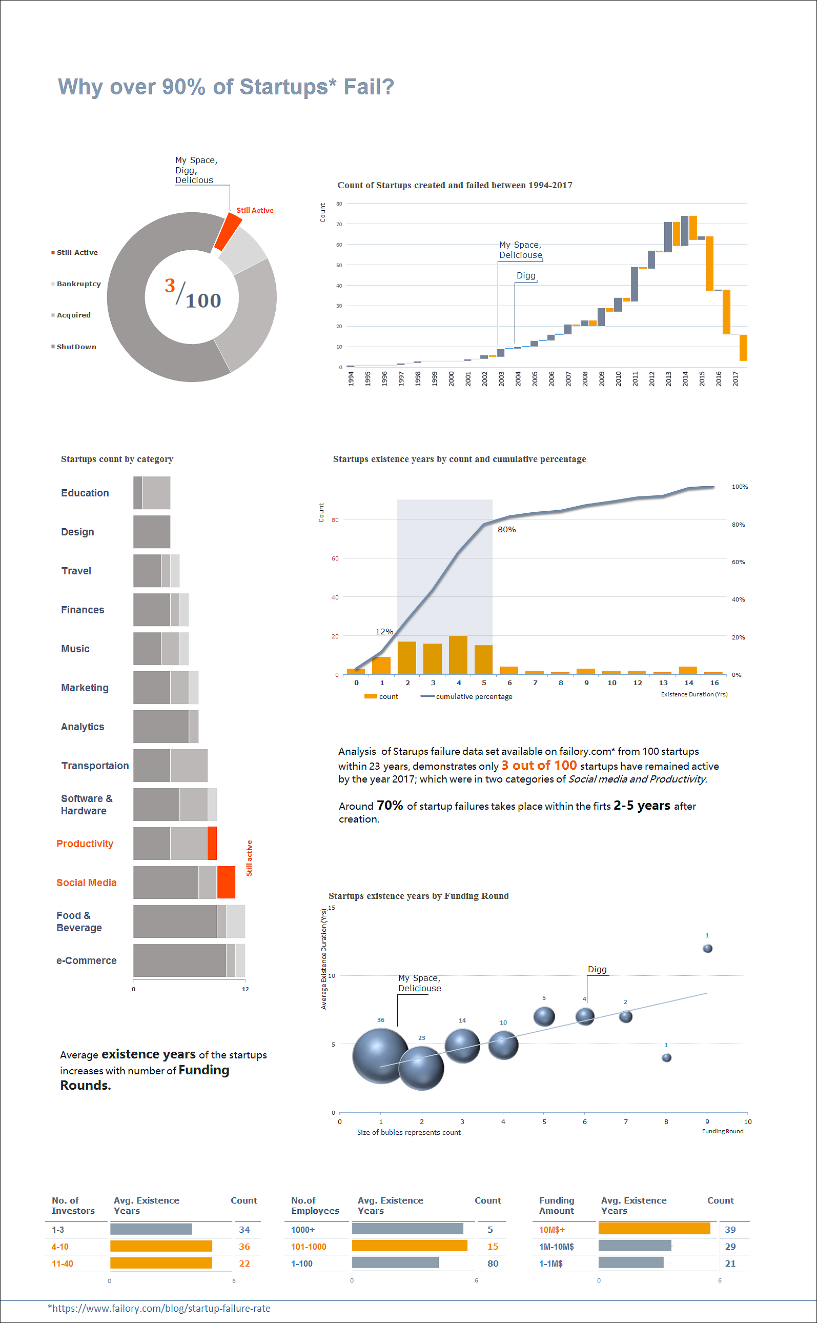
 View projectA new analysis conducted on startups failure data set available on www.failory.com* from 100 startups within a 23 years, shows only 3 out of 100 startups have remained active by the year 2017;...
 -
 View projectThe vision of the future of healthcare. Patients will be engaged, providing them with smart technology so they can closely monitor themselves. They can have devices that will constantly measure...
 -
 View projectThe work "space rocket - way to the moon" deals with the research question of how technically abstract and complex content can be made accessible with the help of targeted group-specific design...
 -
 View projectIn the race to put self-driving vehicles on the street by 2021, major automakers and suppliers are partnering with, investing in and acquiring smaller component makers and technology start-ups
 -
 View projectThis data visualization shows the resistance of Salmonella and E. Coli in food, animals and humans, country by country. It is based on the results of the European Union summary report on...
 -
 View projectThis infographic was produced as an alternate outcome of my final major project at university. I decided to research how to communicate the possibilities of virtual reality and augmented reality...
 -
 View projectThink of a big number, the biggest one you can conceive of. Now add 1. You have a bigger number. You can keep going on and on, until you get to infinity. But is this ‘infinity’ an actual...
 -
 View projectInformation visualization for La Lettura, Il Corriere della Sera Date of publication: 29|04|18 The visualization shows an overview of the cryptocurrencies market in April 2018. It relates...
 -
 View projectOver the past 47 years the weather in Hong Kong has become warmer overall, and we now experience more hot and cold extremes every year.
 -
 View project
On the brink: Explore what’s at risk of disappearing as the climate crisis rapidly alters our world.
From the vast lakes of the US to the mangrove forests of Bangladesh, everything is at stake as the world heats up. In this piece for Earth Day 2023, we look at 16 species and landscapes at risk of... -
 View projectUnwanted Witness is a Ugandan civil society organisation on a mission - to spread the word that our right to privacy is under threat. It’s no easy task. Most people don’t realise just how much...
 -
 View projectThe clearest visualization of bitcoin we have ever seen. After this summer’s massive Petya/NotPetya hack, Keith Collins of Quartz wanted to show what happened to the $10,000 worth of ransom...
 -
 View projectOnline museum collections provide a treasure trove of objects to explore, and allow the public to view a much larger proportion of a museum’s collection than they could see by visiting the museum...
 -
 View projectAn infographic poster explaining the issue of food waste and suggesting solutions for preserving food and reducing waste.
 -
 View project«Energy industry in Ukraine» - our special issue that was fully dedicated to the issues and possibilities of the energy industry. The purpose of the report is to demonstrate our expertise and...
 -
 View projectThis dual language (English/Russian) digital artwork visualises the flights and fates of all the known Soviet Space Dogs. The sad story of Laika, the first animal to go into orbit, is known...
 -
 View projectThis stunning piece of digital journalism is the result of a successful collaboration between the ABC's Tokyo bureau and the Story Lab team here in Australia. Super Kamiokande is a giant science...
 -
 View projectHow a piece of trash can travel from land to Henderson Island, an uninhabited, remote island in the middle of the South Pacific Ocean.
 -
 View projectThis infographic tells the Cassini spacecraft journey, which after 20 years has ended at the borders of the solar system. Designed for La Repubblica Sunday cultural supplement.
 -
 View projectThe first thousand days of a child are the most important to guarantee healthy development. IMAPI is a Nurturing Care Municipality Index that combines over 100 metrics that are strongly related to...
 -
 View projectData shows why the volcanic lightning storm from the Tonga eruption was unlike anything on record. Reuters used data from a ground-based global lightning detection network to visualize the...
 -
 View projectHow has the world's health changed in your lifetime? Put yourself at the centre of our Global Health Check.