
The special project tells us about why it is essential to become a donor and how the issue of blood donation has changed in Russia over the past ten years. There is the interactive tile grid map of...
-
 View projectA brief overview of years 2008 - 2018 The entrant has supplied multiple files for this work: [1] [2] [3]
 -
 View project'Murderous Virus' is an information design that visualizes crime data from 1990 to 2016 in Korea. The number of crimes in each year, crime rate by population, crime rate by region and crime rate...
 -
 View projectThis visualization was my final project for the Introduction to Data Visualization course by Alberto Cairo at the University of Miami. I chose HIV as my project topic based on the article,...
 -
 View projectNormal body temperature is 98.6 degrees Fahrenheit right? Not so. There is no baseline for humans and even if there was, it would be closer to 97.7 °F. This visual shows how temperature fluctuates...
 -
 View projectAround the world, almost 1 million plastic bottles are purchased every minute and they are having a devastating effect on the environment. The Reuters Graphics team visualised plastic bottle...
 -
 View projectThe special project "ISS: Iconic Service to Science" is the most extensive history of the emergence and development of the International Space Station. You can understand how much the station has...
 -
 View projectThis graphic tells a small story about bicycle ridership in Seattle. It does so with a line chart, a sunburst, and a novel chart type: table cartograms (TGRAM) in a treemap. The TGRAM encodes...
 -
 View projectA series of graphics produced to compliment the main SR15 report on the impacts of Global Warming of 1.5°C. The FAQ graphics are intended to back up the graphics in the report and make the subject...
 -
 View projectJPEG images are everywhere in our digital lives, powered by algorithms that remove details that are imperceptible to the human eye. This produces the highest visual quality with the smallest file...
 -
 View projectThis map visualizes the orbits of more than 18000 asteroids in the solar system. This includes everything we know of that’s over 10km in diameter - about 10000 asteroids - as well as 8000...
 -
 View projectMany diseases hold cyclical patterns as a result of climate changes throughout a year. Influenza, or 'the flu', causes the most illnesses in the colder, winter months. However, an outbreak of swine...
 -
 View projectPrivacy Label is a ranking system that aims to address privacy concerns, not just online but also offline. It consists of circular stickers in the form of letter grading; from ‘A’ the best through...
 -
 View projectRussia is a vast country spanning through seven time zones and several climates from southern steppes to northern subarctic. And though it’s citizens rarely encounter actual avitaminosis - critical...
 -
 View projectBritain's coal free record visualisation talks about how Britain is setting new records for going coal-powered energy. It shows the daily share of power generated by burning goal.
 -
 View projectThink you need fast internet speeds to stream Netflix, Amazon or YouTube smoothly? Think again. The Wall Street Journal’s extensive test data shows that typical U.S. households don’t use most of...
 -
 View projectAn information graphic designed to tell the story of the Internet. This 28x72in banner titled, “The Internet: A Population” focuses on the number of people across the world who are connected to the...
 -
 View projectLooking at the bunches of lab tests I had gathered since 2003, I decided to visualize my TSH lab results and other thyroid hormones. I was diagnosed with Hyperthyroidism and Graves Disease in 2003,...
 -
 View projectThe increased industrialization of farm animals has not only affected the number of animals processed every year, but has also had immense environmental effects on the air, land, and water of the...
 -
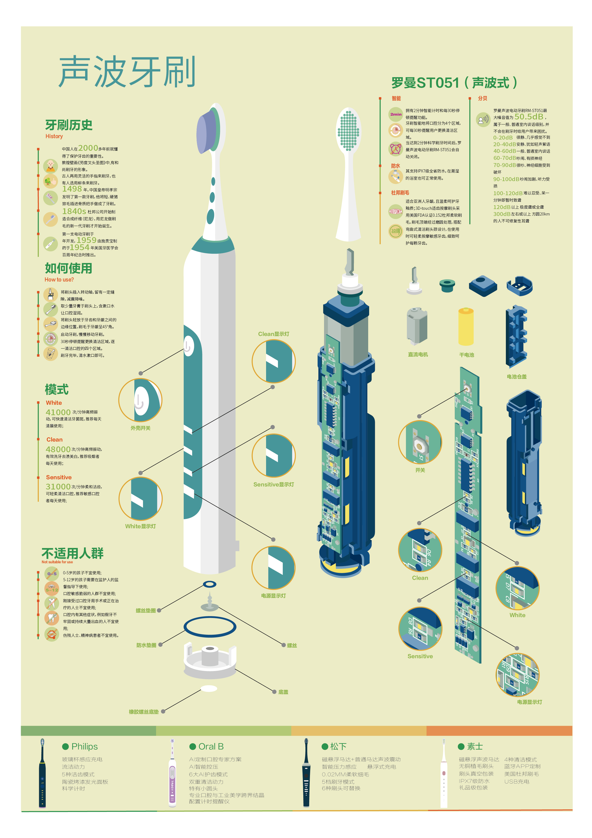
 View projectThis is an infographic introducing the Roman ST051 sonic toothbrush, which interspersed with some knowledge about electric toothbrushes.
 -
 View projectHow do we begin to evaluate the impact of autonomous vehicles and shared mobility services on congestion? How do we embrace the uncertainty surrounding these new mobility technologies? Cities...
 -
 View projectThe European Union Emissions Trading System (EU ETS) is one of the EU's cornerstones in its strategy for cutting emissions of manmade carbon dioxide (CO2). This visual piece explores how it works...
 -
 View projectHumankind has been launching satellites and rockets into space for 60 years, filling Earth’s orbit with masses of debris with China’s expanding space programme a major contribution to the issue. An...
 -
 View projectChicktopia means the utopia of chicken where the chicken follow their duties in this society, work hard, live their lives fast and finally achieve their noble goals as being products for human.I...
 -
 View projectNickel allergy is highly related to eczema and atopic dermatitis. Even though it is impossible to completely avoid nickel in our diet, lowering nickel consumption could help manage these skin...
 -
 View projectThis infographic offers an in-depth look at the state of global fishing. It compares the most used fishing techniques and their impact, the most fished species and their provenance, the global...
 -
 View projectThe vision of the future of healthcare. Patients will be engaged, providing them with smart technology so they can closely monitor themselves. They can have devices that will constantly measure...
 -
 View projectSwimming pools in the United States can do more harm than good. Not many people in America realize how much pools hurt the environment. An infographic poster can help shed a little light onto the...
 -
 View projectThis work presents changes of the angle at which the Sun's rays strike the Earth's surface during the year. It is aiming to explain what causes the change of seasons. I calculated the angle of...
