
This wiz maps the numbers of tigers before and after the conservation program worldwide, as well as in India.
-
 View projectThis publication explores plastic bag usage in the UK, considering the juxtaposition of perspectives from the supermarkets and in turn the consumers. The data presented visualises: The number of...
 -
 View projectThe report presents the generation, collection and treatment of waste in Mexico City. This process is represented in a data visualization that shows how many tons of waste are generated by the city...
 -
 View projectA just transition to a net zero world needs to be inclusive. In this visualization, we explore equity and equality, the relationship between wealth and CO2 emissions, and the impacts of climate...
 -
 View projectThis exploration is done as a school project for the data analytics and visualization program at MICA (Maryland Institute College of Art). This work is not affiliated with the Bird Life...
 -
 View project‘Inspiring a Movement: The Warming Stripes’ is a visualisation depicting and evaluation how Ed Hawkin’s famous ‘Warming Stripes’ graphic has grown over the last 4 years, becoming a global symbol of...
 -
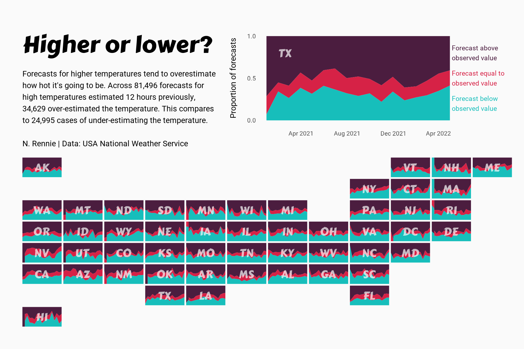
 View projectThis chart visualises the accuracy of high temperature forecasts made by the USA National Weather Service between January 2021 and June 2022, within a 12 hour window. Proportional area charts show...
 -
 View projectThis is an infographic on India's wildlife sanctuaries and parks, and covers 1> Number of sanctuaries and parks 2> Zone-wise, state-wise and area 3> year of their establishment
 -
 View projectA multi-angle analysis of the 2022 UK housing market, which breaks the (positively-skewed) dataset into quartile groups based on house price with a top outliers group for the stately homes and...
 -
 View projectThe island of Hawaii (also known as Hawaii's "Big Island") is made of five volcanoes. This map visualizes these volcanoes in a simple, straightforward, and stylized way — the volcanic peak (center...
 -
 View projectThe Nakaiy Almanac visually merges indigenous knowledge and weather data, showcasing the value of an intricate and historic understanding of weather patterns and of emerging changes in weather...
 -
 View projectWhen it comes to sand mining, the Singapore government is often closed to scrutiny. As a result, it is often cast as a villain, guzzling sand from its neighbours while it grows bigger through...
 -
 View projectRuas do Género: Exploring Gender Representation in Urban Toponymy "Ruas do Género" is a visual essay that explores the issue of gender representation in the street names of Porto, Portugal. How...
 -
 View projectWith climate change raising Arctic temperatures faster than the global average, wildfires are shifting poleward where the flames blaze through boreal forest and tundra and release vast amounts of...
 -
 View project“World Heritage in Danger 2023” is an information design and data visualization project with an aim to raise awareness of decaying beauty in our world with a skeptical overtone. The data...
 -
 View projectCurbing global warming, halting the loss of biodiversity, and building a just and equitable economy are among the world’s most pressing needs. To track progress and reveal systemic obstacles to...
 -
 View projectClimate change has had catastrophic effects on California’s forests, but the proposed solutions to protect them have ignored certain voices. This infographic shows how rising temperatures have...
 -
 View projectBirds start singing in the early morning. What can be heard in the morning reveals a lot about the human impact on nature and biodiversity. This article explains how human activity has impacted the...
 -
 View projectExplore ongoing campus transformations. Track construction progress and completion dates through interactive visuals on our college map.
 -
 View projectWhen geometry and human intuition meet: What becomes of the intersection between pragmatic visual tools and emotion? Everybody worries about something. Worrying is an act of the everyday that...
 -
 View projectThe project comprises a publicly accessible, interactive webmap, aimed to communicate the rise and fall of London’s Low Traffic Neighbourhoods (LTNs) temporally over the course of the 2 year COVID...
 -
 View projectThe Historical Marker Database tracks the location of markers that identify where historical events occurred. Many markers have since been reported, and in some cases confirmed, as missing. This...
 -
 View projectI decided to visualize the largest lakes around Berlin using a new technique in Illustrator. This was a fun project to familiarize myself with my new living area and practicing the language while...
 -
 View projectDuring winter 2022-2023 California experienced record snowfall, with some areas receiving over 20m (65ft). This map illustrates this snowfall thematically using 50 sq km hex-bins that each show the...
 -
 View projectThis is a visualization chart of public spaces in university which can be accesible by wide range of students and still is. It depicts the information which area has how much place and where
 -
 View projectBoar straying into urban areas has been a problem in many modern cities, the boar problem in Hong Kong refers to the increasing population of wild boars in urban areas. Rapid urbanization has...
 -
 View projectWhen I close my eyes and visualize Hyderabad, what emerges in my mind's eye? Which landmarks, streets, or corners resonate with my memories? What sights, sounds, and emotions epitomise the...
 -
 View projectThis infographic shows the layout of the gym and all the equipment placed inside. The equipment are categorized by three categories: Leg, arm and ab workouts. Secondly, the registration process and...

