
The digital realm and the physical world are not entirely separate; they communicate, reflect, and engage in debate with each other. Considering this relationship, the following question arises:...
-
 View projectThis interactive narrative aims to illustrate the contrasting disparities in the lives and opportunities of children in Eastern and Western Europe, using the metaphor of children's books. Not all...
 -
 View projectThe Water-Energy-Food (WEF) Nexus Index is a national-level composite indicator founded on 21 relevant indicators. This website provides a user-friendly visualisation of the index and an entry...
 -
 View projectThe project comprises a publicly accessible, interactive webmap, aimed to communicate the rise and fall of London’s Low Traffic Neighbourhoods (LTNs) temporally over the course of the 2 year COVID...
 -
 View projectAccording to a recent report by Moody’s, 2022 marked the first time in nearly 25 years of recordkeeping that the average American household needed to spend more than 30% of their income on rent....
 -
 View projectThe article explores the historical significance of the rubber industry in Singapore and its deep-rooted impact on the present discourse surrounding migrant workers in the country. As recent as...
 -
 View projectThe Historical Marker Database tracks the location of markers that identify where historical events occurred. Many markers have since been reported, and in some cases confirmed, as missing. This...
 -
 View projectThe island of Hawaii (also known as Hawaii's "Big Island") is made of five volcanoes. This map visualizes these volcanoes in a simple, straightforward, and stylized way — the volcanic peak (center...
 -
 View projectThe UNICEF Global Database on School-Age Digital Connectivity tracks the percentage of children 3 to 17 who have internet connectivity at home. The United Kingdom has the highest percentage at...
 -
 View projectClimate change has had catastrophic effects on California’s forests, but the proposed solutions to protect them have ignored certain voices. This infographic shows how rising temperatures have...
 -
 View projectSeries of infographics on the lack of sustainability of nuclear energy for the magazine "Energy & Environment". On six pages, the graphics are devoted to exciting facts and problematic aspects...
 -
 View projectThe project attempts to understand the water consumption in the Design hostels. The data was collected with the help of the warden of the hostels and the plumbers who maintain the same. The...
 -
 View projectIs it spring yet? New green plant growth is one of the first indicators of spring and the end of cold winter months. To celebrate the changing seasons in the United States, the United States...
 -
 View projectAugust 15th, 2023 marks the first National Ecological Day in China. Our focus turns to plastic that can be seen everywhere. In 1950, only 2 million tons of plastic products were produced...
 -
 View projectIn November 2021, the foreign minister of Tuvalu addressed the climate summit COP26 while standing knee-deep in the ocean to raise awareness of the imminent threat sea level rise represents for...
 -
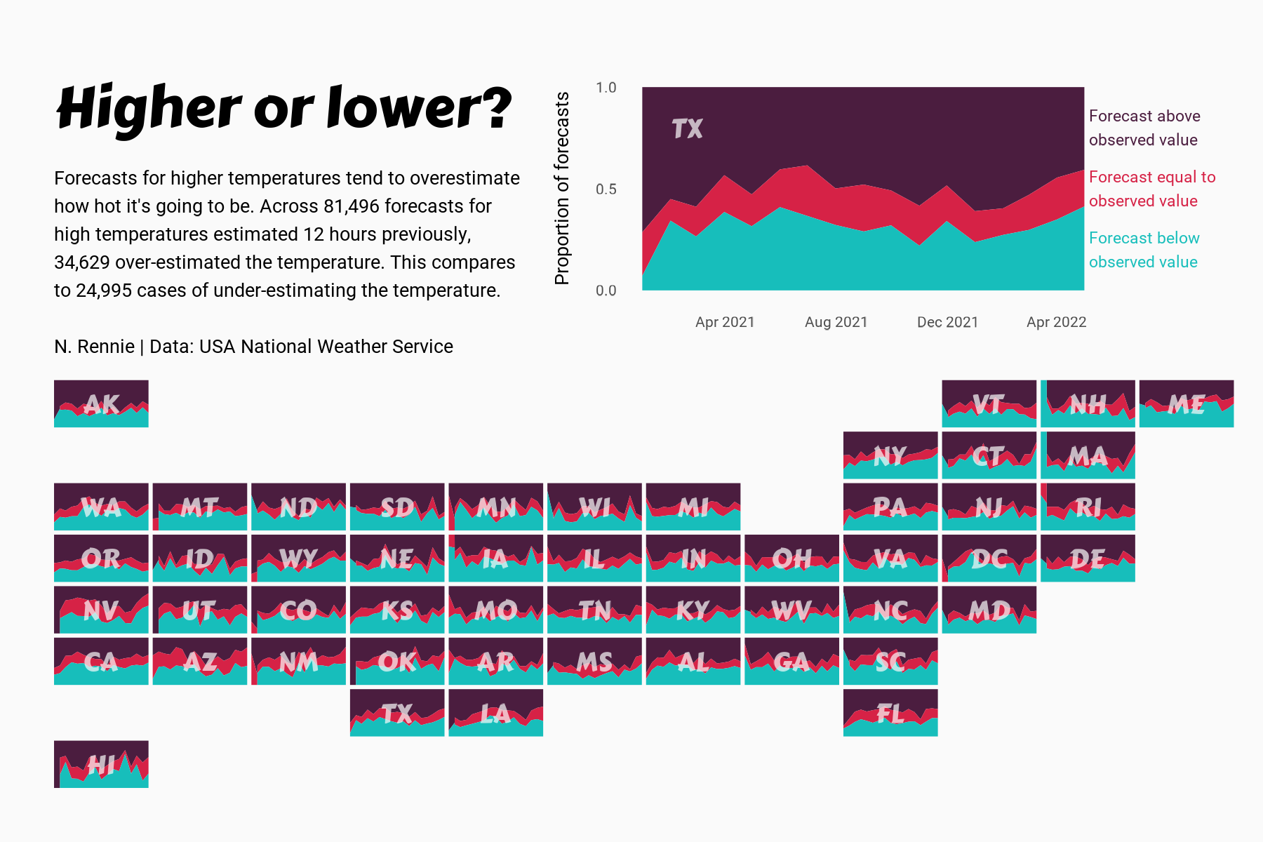
 View projectThis chart visualises the accuracy of high temperature forecasts made by the USA National Weather Service between January 2021 and June 2022, within a 12 hour window. Proportional area charts show...
 -
 View projectA visual summary of the the percent year-over-year change during each month in 2020 across 11 sectors. Data on retail sales comes from the US Census Bureau's Monthly State Retail Sales data product...
 -
 View projectThe most diverse group of organisms on the planet are in trouble, with recent research suggesting insect populations are declining at an unprecedented rate. Amid deforestation, pesticide use,...
 -
 View projectCurbing global warming, halting the loss of biodiversity, and building a just and equitable economy are among the world’s most pressing needs. To track progress and reveal systemic obstacles to...
 -
 View projectIf I'm on a road trip, I'm stopping at McDonald's. I wanted to look at McDonald's restaurants in a way that shows just how far they stretch across the country, while always maintaining those...
 -
 View projectI have created an infographic designed for the primary audience of head staff members who navigate their Excel spreadsheets to assign rooms to new employees at the university. This visual aid aims...
 -
 View projectThis is an information visualisation of the upcycle yard at our design college. Its official purpose is to collect scrap from around the college and then engage in recycling activities but it has...
 -
 View projectEnvironmentalists have warned for decades that Mekong River dams were threatening the natural flow of sediment – a centuries-old system delivering nutrient-rich mud down the 5,000-km waterway to...
 -
 View projectIntroducing "Carbon Emission of the World," a captivating Tableau dashboard designed to shed light on the pressing issue of carbon emissions. This visually compelling and informative report offers...
 -
 View projectHousing availability in cities across America is failing to keep up with growing populations. To address this crisis, policymakers have begun to reconsider local zoning laws - the rules that limit...
 -
 View projectI did a survey and observed cycles in and around my college campus based on their condition if they are geared or non-geared, where they are located, whether they are locked or not and much more....
 -
View projectExplore ongoing campus transformations. Track construction progress and completion dates through interactive visuals on our college map.
-
 View projectWe are sensorial creatures who inhabit the world surrounded by sensory data (Serres, 2008); also, we experience the world by continually engaging all the senses (Le, 2017). In such a context, we...

