
August 15th, 2023 marks the first National Ecological Day in China. Our focus turns to plastic that can be seen everywhere.
In 1950, only 2 million tons of plastic products were produced...
-
 View projectThe Infographic show important details about the mess in the university campus for the students.
 -
 View projectEnvironmentalists have warned for decades that Mekong River dams were threatening the natural flow of sediment – a centuries-old system delivering nutrient-rich mud down the 5,000-km waterway to...
 -
 View projectWe commemorate 150th anniversary of the unification of Buda, Pest and Óbuda into Budapest with a series of 50 alternative maps, mainly produced from open source or publicly available data. The maps...
 -
 View projectThe Water-Energy-Food (WEF) Nexus Index is a national-level composite indicator founded on 21 relevant indicators. This website provides a user-friendly visualisation of the index and an entry...
 -
 View projectThis exploration is done as a school project for the data analytics and visualization program at MICA (Maryland Institute College of Art). This work is not affiliated with the Bird Life...
 -
 View projectThe article explores the historical significance of the rubber industry in Singapore and its deep-rooted impact on the present discourse surrounding migrant workers in the country. As recent as...
 -
 View projectI did a survey and observed cycles in and around my college campus based on their condition if they are geared or non-geared, where they are located, whether they are locked or not and much more....
 -
 View projectThis project is part of a permanent exhibition at Fondazione Pistoletto (Biella) and was created in collaboration with some local organizations. The theme is water: from the laws that regulate...
 -
 View projectExplore ongoing campus transformations. Track construction progress and completion dates through interactive visuals on our college map.
 -
 View projectIn recent years, Indonesia has witnessed a significant rise in earthquake activity, attributed to its location within the seismic hotspot known as the Ring of Fire. The convergence of tectonic...
 -
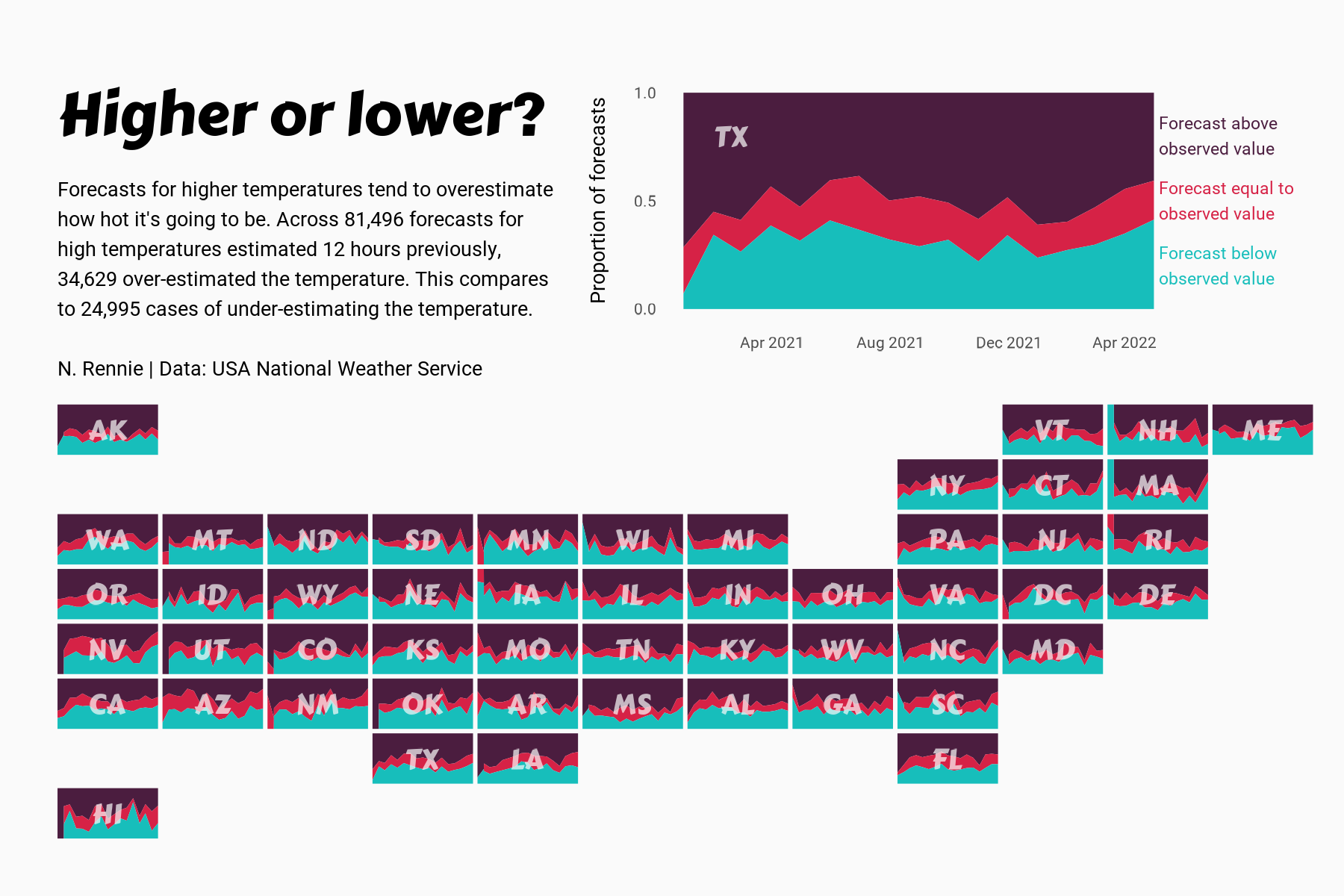
 View projectThis chart visualises the accuracy of high temperature forecasts made by the USA National Weather Service between January 2021 and June 2022, within a 12 hour window. Proportional area charts show...
 -
 View projectBirds start singing in the early morning. What can be heard in the morning reveals a lot about the human impact on nature and biodiversity. This article explains how human activity has impacted the...
 -
 View projectA creative and experimental map-like visualisation crafted for cheese and wine lovers. Depiction of the principal vineyard regions in Metropolitan France as red wine spills fallen on a...
 -
 View projectWhen I close my eyes and visualize Hyderabad, what emerges in my mind's eye? Which landmarks, streets, or corners resonate with my memories? What sights, sounds, and emotions epitomise the...
 -
 View projectThis publication explores plastic bag usage in the UK, considering the juxtaposition of perspectives from the supermarkets and in turn the consumers. The data presented visualises: The number of...
 -
 View projectForecast is a nostalgic window that uses light and mist to experientially recreate past weather conditions for a future civilisation forced underground by climate change. Inspired by the rising...
 -
 View projectWith climate change raising Arctic temperatures faster than the global average, wildfires are shifting poleward where the flames blaze through boreal forest and tundra and release vast amounts of...
 -
 View projectSankey diagrams show the distribution of households according to security experience and household income, the frequency of interruption of water supply according to income, and the frequency...
 -
 View projectInvestigating digital inequalities in L'Hospitalet de Llobregat through storytelling, interactive data visualizations, and 5 fictional characters representing at-risk individuals.
 -
 View projectThe Historical Marker Database tracks the location of markers that identify where historical events occurred. Many markers have since been reported, and in some cases confirmed, as missing. This...
 -
 View projectWhat is the definition of drought? The drought problem due to climate change is frequently in the news. But what exactly is drought? When I consult the site of KNMI (The Royal Netherlands...
 -
 View projectA network map showing all of the New York City Subway Lines and ranking of line by length of line and number of stations along line.
 -
 View projectNumber of cherry blossom trees per 293 x 365 meters (represented by each hexagon) planted in Washington D.C.
 -
 View projectThe report presents the generation, collection and treatment of waste in Mexico City. This process is represented in a data visualization that shows how many tons of waste are generated by the city...
 -
 View projectHumans grow and waste food at a staggering scale. We devote half the earth’s habitable land to food production, while ultimately tossing one-third of that food. Simply using the food we grow and...
 -
 View projectThe wolf – 2 sides of the discussion The wolf is back in the Netherlands and causing a big stir. While reading and listening about the wolf, I learned a lot, for example: - the wolf needs 4 kg...
 -
 View projectThis is an infographic on India's wildlife sanctuaries and parks, and covers 1> Number of sanctuaries and parks 2> Zone-wise, state-wise and area 3> year of their establishment
 -
 View projectData Soap is a personal documentary project presenting individuals’ household water stories with data and emotion. It allows the audience to glimpse people’s lives. The data is transformed into an...
