
This personal project presents the visual research of top tennis players' careers. The visualization tells us about their achievements and way to the first place in ATP/WTA ranking of top players....
-
 View project"Histography" is an interactive timeline that spans across 14 billion years of history, from the Big Bang to 2015. The site draws historical events from Wikipedia and self-updates daily with new...
 -
 View projectHave you ever wanted to see a snapshot of your music taste? Most of us enjoy songs spanning several different genres. These are not always clearly distinct, sometimes they overlap, and sometimes...
 -
 View projectThis graphic is a visualization of the history of US state boundaries. It gives an overview of current and past state boundaries throughout the country's entire history, combining time and space in...
 -
 View projectThis was done as a part of a 2 weeks Geo-visualisation module at the National Institute of Design, Bengaluru. This is an online data article on terror groups in India. The Data set was taken...
 -
 View projectStyle, skills, power, character, charisma. The noble art is much more than a bunch of numbers, but what does data tell us?
 -
 View projectHaller’s Journey is an immersive story map inviting the reader to follow along the botanical journey of Albrecht von Haller, an 18th-century botanist, and physician. In 1739, Haller left his...
 -
 View projectIn 1939, ethnomusicologists John and Ruby Lomax set out on a 6,502 mile journey across the Southern United States collecting folksongs on behalf of the Library of Congress. Using maps, music and...
 -
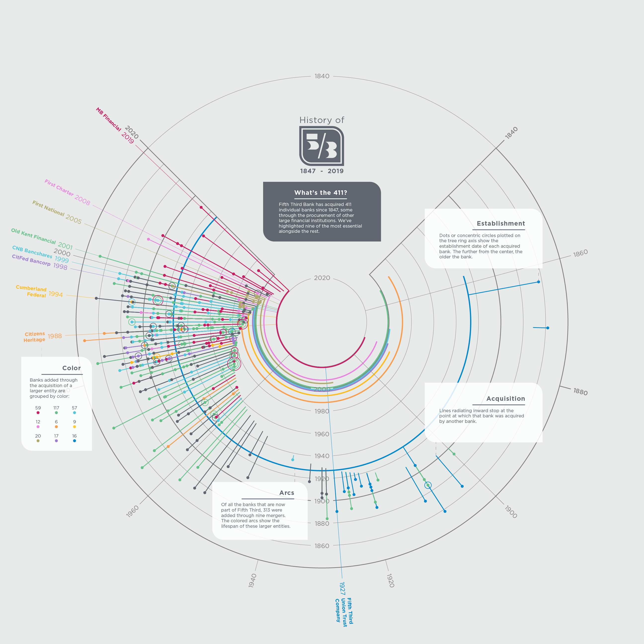
 View projectFifth Third Bank recently opened a museum to honor its 161-year history. A recent review of its history found that 411 distinct banks make up the Fifth Third Bank of today. This visual depicts...
 -
 View projectThe visualization shows the collection of historical drawings by Frederick William IV alongside a thematic and temporal arrangement. The aim was to highlight thematic and historical connections...
 -
 View projectThe Institute for Higher Education Policy (IHEP) hired Graphicacy to transform a trove of data into compelling visual stories that depict how postsecondary educational institutions create value and...
 -
 View projectWith this Data Visualization, created exclusively for the competition, I wanted to offer a way to understand terrorist phenomena around Europe, in order to have a clearer vision about policies of...
 -
 View projectEmoto captured and visuÂalÂised the global response around the London 2012 Olympic Games on Twitter. The project consisted of an interactive online visualization, realtime data-journalism...
 -
 View projectAcross the relationship that exists between the brain and human emotions, there is a spectrum that goes beyond the tangible; To explore it, we present this project with the aim of breaking down the...
 -
 View projectOn the 50th anniversary of Apollo 11’s moon landing, the National Aeronautic and Space Administration (NASA) is setting its sights on returning to the moon, and going far beyond. This interactive...
 -
 View projectUnveil MIT's cupboard usage insights! My project deciphers trends in MIT's varied areas – academic, maker spaces, dining, admin, and sports. Visualize data to optimize usage, allocate smartly, and...
 -
 View project“Sound and Vision” is a project, which analyses and visualises different songs of Björk’s album “Homogenic”. The sound sculptures are exploring characteristics of the artist and the album. Are...
 -
 View projectThe annual number of deaths of children under 5 years of age around the globe decreased from 19.6 million in 1950 to 5.4 million in 2017, a change of nearly 72%! Undoubtedly the decrease in child...
 -
 View projectBBC Knowledge commissioned Territory Studio (territorystudio.com) to produce an animated film on the subject of DNA. Three minutes is a short time to explore a subject where most doctorates only...
 -
 View projectAs data visualisations have ‘the potential for meaning-making’ (Engebretsen and Kennedy, 2020), it is important for the general public to have expertise with the fuzziness of data (Cairo, 2017)...
 -
 View projectThis visualization examines the emotions that voters have felt towards presidential candidates over the past 30 years.
 -
 View projectAfter having discovered that his steps were being monitored by a smartphone, he decided to take advantage of all unused collected data. Believing in the value of simplicity and following the...
 -
 View projectHow Hong Kong has changed since handover from music to politics, fashion to infrastructure, these graphics explore the evolution of Hong Kong on the 20th anniversary of the city’s handover from...
 -
 View projectThe “Tokyo Eat Map” is an experimental data visualization in 3D with a “meta” reference to the data it displays. It represents the density of restaurants in central Tokyo on a map, morphed into...
 -
 View projectI designed this infographic after being inspired by a post on the Economist's website. The Economist Intelligence Unit (EIU) created a –Where To Be Born Index' in 1988 and now again in 2013. The...
 -
 View projectOver one year in Boston, 1,064,053 people cycled 16,548,483 mins in total. They burned 56,264,845 calories and saved 1,581,331,745 g CO2 emissions compared to if their journeys were by car. This...
 -
 View projectContrapedal was the first project of the "Datalab" of X-DATA, a Mexican data analytics and visualization company. Miguel Zúñiga, information designer and creator of Contrapedal, mixed his two...
 -
 View projectThis is one of four posters in a series, representing Moscow Urban Forum on World Cities Summit 2014 in Singapore. Despite geographical and cultural differences, big cities all over the world...

