
With some occupations, people make more annual income than others, but we typically see figures in terms of means and medians when in reality, the difference between the person who makes the...
-
 View projectThis interactive visualisation aims to display traffic accident information as kept by Transport for London for the year 2015.
 -
 View projectExplore how conversation unfolded at any given moment by clicking on different parts of the timeline. The lines and flying bubbles show the influx of Retweets to a given country.
 -
 View projectThis tool presents biological data for all 55 distinct salmon populations found in the Skeena River watershed, as well as maps of current human and environmental pressures on freshwater and...
 -
 View projectShipmap.org is an ambitious interactive WebGL map of commercial shipping movements based on hundreds of millions of data points from throughout 2012 (the most recent year for which all the raw...
 -
 View projectThis poster explores the disciplines or professions of creators and theorists who marked the history of data visualization. In the 18th and 19th century, visualizing data is used for thinking...
 -
 View projectAn animated visualization of commuting patterns for US counties operating at the US Census Tract level. Tract to tract flows are shown based on user selected criteria.
 -
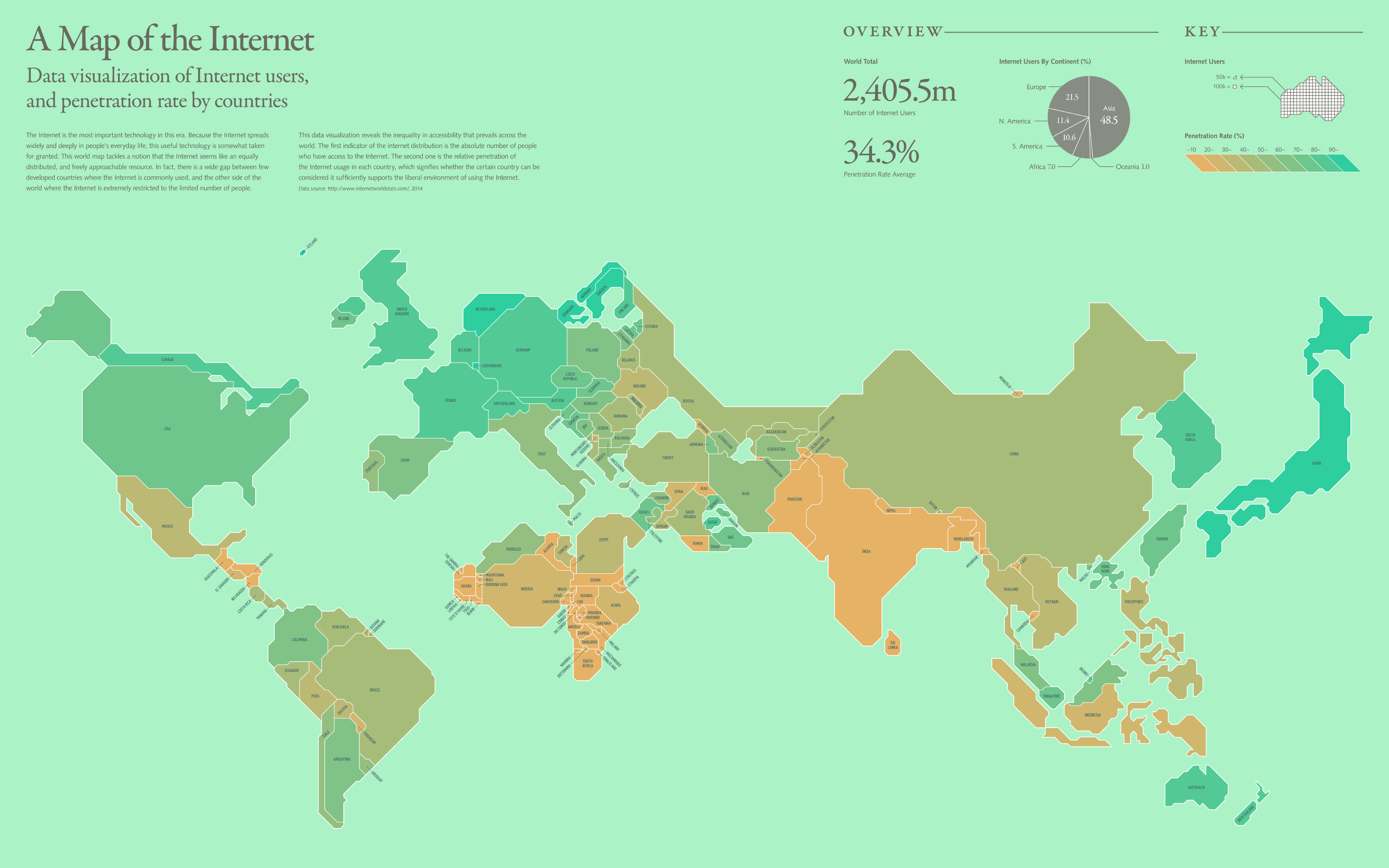
 View projectThe Internet is the most important technology in this era. Because the Internet spreads widely and deeply in people's everyday life, this useful technology is somewhat taken for granted. This world...
 -
 View projectHow long does a citizen have to work in order to afford common medicines? This data analyses the price to income ratio in each country.
 -
 View projectWTF Vizualizations publishes infographics and dataviz that make no sense, together with a Twitter community analysing why.
 -
 View projectThis is a map showing over five years of drought data (285 weeks, combined into a single view) in the United States. The dots are proportionally sized by the amount of time over the past five...
 -
 View projectInfographic summarizes the cases of corruption investigated and prosecuted in Valencia and its main defendants. It is shown in chronological order each case to see in the time from when...
 -
 View project“Plastic Garbage Island” is the first cover story published on Visualeyed.com, it’s an article about marine debris with a focus on plastic garbage. The article is enriched by interaction,...
 -
 View projectAfter some lengthy investigative work, I was leaked an internal report by Transport for London revealing a 121% increase in reports of rough sleeping on London’s night buses. But the numbers needed...
 -
 View projectIn December of 2015, the Supreme Court heard Evenwel v. Abbott, a case that could have drastically altered how election districts are drawn by counting eligible voters instead of all residents....
 -
 View projectThe project is a work of visualization illustrating the living cost of normal residents in Shanghai. We calculated the average price of housing within 1km away from each metro station by collecting...
 -
 View projectThe artwork shows on the left side the refugees who fled from their country of origin from 1980 to 2015, while on the right side the nations that have given asylum to refugees. The nations that...
 -
 View projectProbe the solar system from Mercury to Pluto with this stellar schematic of space exploration! From the Luna 2 in 1959 to the DSCOVR in 2015, this color-coded chart traces the trajectories of every...
 -
 View project675 people have been shot and killed by police in 2016. This database is based on news reports, public records, social media and other sources.
 -
 View projectIn almost every urban area on every continent around the world, pigeons solemnly blend into the cityscape aesthetic. Usurping sidewalks and parks in their massive unflattering flocks, pigeons are...
 -
 View projectBy visualizing data on air travel, tourism, Erasmus student migration, and marriages within Europe, my project (created using D3.js) aims to explore the social connection between European Union...
 -
 View projectWhat do Uber, Blue Apron, Classpass, Deliveroo, and Ticketmaster all have in common? They are all apart of the On-Demand Ecosystem --a model built on instant gratification. Since 1976, 673...
 -
 View projectTwenty-four solar terms is according to the sun in the ecliptic (the earth's orbit around the sun) on the position of the change and develop. Twenty-four solar terms can reflect the change of...
 -
 View projectIf there is anything in the world that warrants attention it’s education. How can one really analyze how far has education come if not from a vantage point? Astronomy has long been a human reminder...
 -
 View projectPeople travel not just more frequently, but increasingly far and quickly. Mapping the connections between all the airports worldwide is a fascinating network visualization exercise. A network, in...
 -
 View projectMapInSeconds lets people create choropleth maps just by copying and pasting data from a spreadsheet/Excel. A major goal of this is to make map-making straightforward and accessible. The maps can...
 -
 View projectHow old are you? How old were the great and the good when they peaked, or got their big break? WHO old are you?


