
An interactive map of all of London's nature reserves and designated wildlife sites, Nature Reserves of London encourages Londoners and visitors alike to explore the wealth of woodland, wetland,...
-
 View projectHow does your zip code impact your health? We paired over 250 social determinant variables against claims for over 150,000 patients to create a social determinant risk scoring model. Check out our...
 -
 View projectDear Judges: More than six million people visited the Grand Canyon National Park in 2018. In 2019 people kept coming, undeterred by the three deaths in the first three months of the year. Since...
 -
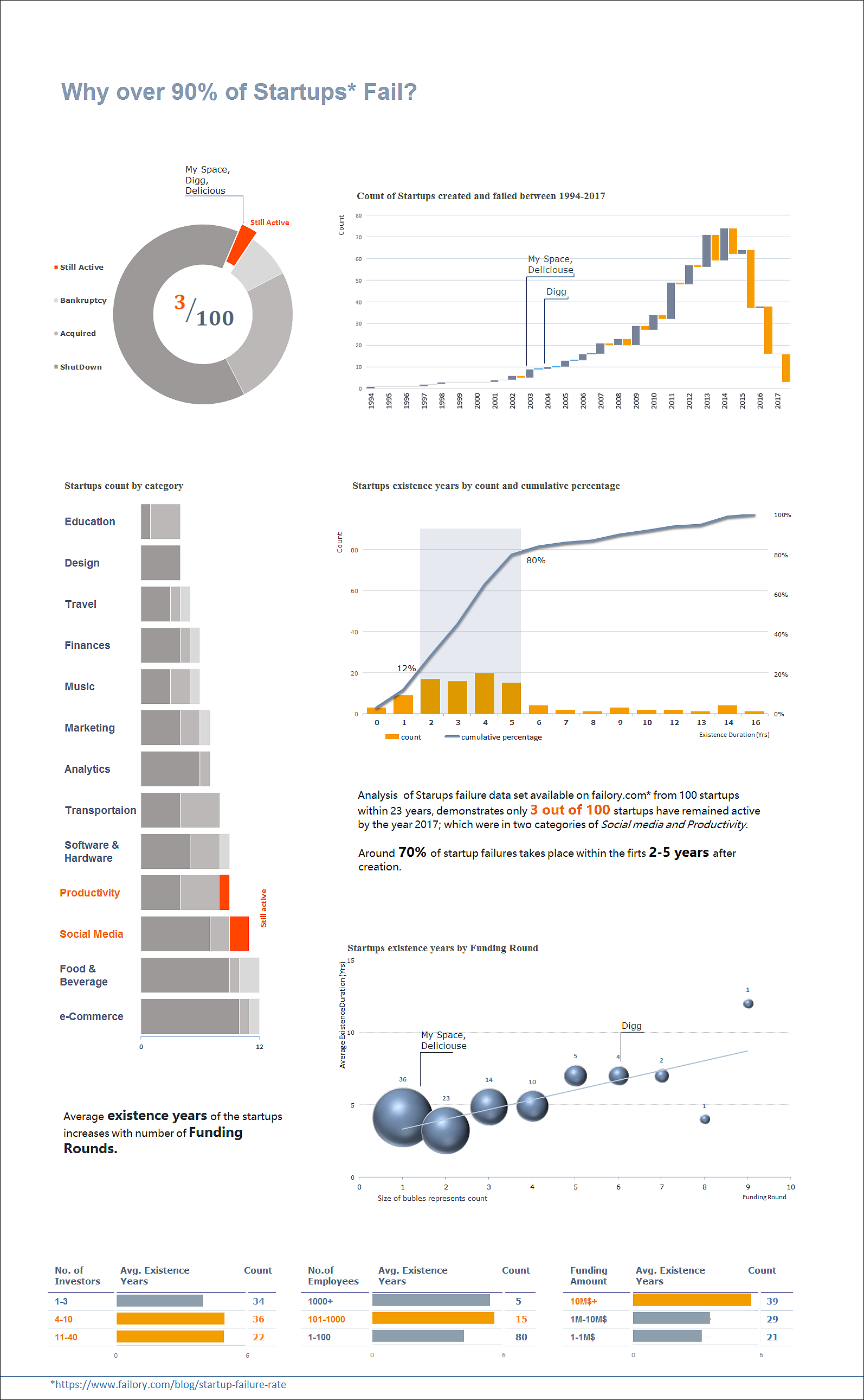
 View projectA new analysis conducted on startups failure data set available on www.failory.com* from 100 startups within a 23 years, shows only 3 out of 100 startups have remained active by the year 2017;...
 -
 View project"The Kit War" is an interactive and filterable data story about the apparel brands of the 500 top football clubs and all 211 FIFA affiliated national teams. It analyses the distribution of...
 -
 View projectSometimes we have to challenge readers' sensibility so we can build a better world. This cut-out infographic includes a mid-upper-arm circumference (or MUAC) bracelet, which is used to help assess...
 -
 View projectThe STS Transit for Art, Design, and Performance map was designed as a visual guide to the book chapter “Art, Design, and Performance” from The Handbook of Science and Technology Studies. As an...
 -
 View projectI produced a series of posters illustrating the narratives of well-recognised fairytales: “The Three Little Pigs”, “Cinderella” and “Goldilocks and The Three Bears.” I have visualised these...
 -
 View projectThe R, Python and D3.js graph galleries are three websites that display more than a thousand chart examples with their reproducible code, using the three main programming languages currently used...
 -
 View projectThe Lifespan Of News Stories is a collaboration between Schema, Google News Initiative, Alberto Cairo and Axios. The project analyzes the shape of search interest data from the top news stories of...
 -
 View projectThe Harvest Chart visualizes the weekly crop harvest of fruits and vegetables across the United States in an interactive data visualization. The design objective for the project was to answer a...
 -
 View projectThis map visualizes the orbits of more than 18000 asteroids in the solar system. This includes everything we know of that’s over 10km in diameter - about 10000 asteroids - as well as 8000...
 -
 View projectEvery year, humanity is leaking more and more plastic into the world's oceans. Plastic does not dissolve. Instead it is ground into smaller and smaller pieces at the micrometer and nanometer...
 -
 View projectA lo-fi visualization to illustrate using the language of data the expressive possibilities of developing a sensory-based technology for the digital fine artist. The data seen is selective, and...
 -
 View projectIn 2012, fourteen buildings on Beijing's central axis were included in China's preliminary list of world heritage sites. As the historical and cultural buildings of the ancient capital of the six...
 -
 View projectA look into the 2019 Men's Golf tournament hole by hole results for both stroke on match play. Follow the top 8 teams throughout the tournament as they progress through each round. The entrant...
 -
 View projectThe markets have always been influenced by a series of external factors. But how, and in what manner? This infographic compares the impact of one main event per month on the monthly closure of the...
 -
 View projectThe project is called after scientific Cell Theory as a metaphor of all live systems kinship. This is a collection of handcrafted prints with data visualizations, exploring the issue of human...
 -
 View projectPeople living with HIV are around 20% times more likely to develop Tuberculosis than persons without this disease. Tuberculosis is the most common illness among people living with HIV, including...
 -
 View projectIn collaboration with OECD, we created an interactive data platform to help countries assess their state of digital development and formulate policy strategies in response. The toolkit supports the...
 -
 View projectHow can we measure the impact of the most important scientists on our society? Many factors can be considered: industrial applications, scientific prizes, etc. One of them is the analysis of their...
 -
 View projectRelive the flow of the epic Men's Singles Final through this analysis that utilises vertical jump plots to visualise the length of each game and dot plots to display the winner of each point.
 -
 View projectVisualization attempts to address the most common threat for local residents in Nepal - landslide collapsing over the road network. There are many technical solutions that could protect the road...
 -
 View projectHave you ever wondered which cities have won the most championships in the four major sports leagues? In this visualization, each petal of the flower chart represents one of the four major sports...
 -
 View projectThis visualization looks at the win percentage over the past 25 years for the NCAA college football pre-season top 25 teams. The year 1994 is shown at the 12:00 position and each year can be...
 -
 View projectToday, by simply walking in the streets of Cairo or tuning into one of the national TV channels, one is captured by hundreds of real estate billboards and TV ads that share certain characteristics....
 -
 View projectIn just two decades of the new century, Russia did come so far. And so did it’s people’s lifestyle and social structure which changed along with rising economic well being. This long read is an...
 -
 View projectWe think that the world is fascinating. That is why we created Factourism combining our love of strange facts with our love for illustration. Factourism is an ever evolving series of illustrated...
 -
 View projectOur OS Maps users created over 300,000 public routes across Great Britain in 2018 (covering some 2,950,000 miles…) and we were curious to see where you most (and least) enjoy exploring. The...
 -
 View projectThis infographic was made for class with the intent of informing anyone who views it information on bats and how important they are for people and the environment to help spread awareness to the...