
Data is nothing without context. How can we understand a city without first understanding the characteristics of a normal or typical city? I crunched the numbers on eight measures of 917 cities to...
-
 View project“World Heritage in Danger 2023” is an information design and data visualization project with an aim to raise awareness of decaying beauty in our world with a skeptical overtone. The data...
 -
 View projectA data-driven portrait of UAE’s milestones, population, and GDP over 50 years. Data is powerful. When used correctly, it can tell an even more powerful story. Using 379 data points i.e. 50 years...
 -
 View projectA lot of people move to Dubai, an emirate in United Arab Emirates, to start their own business and live the entrepreneurial life, given the relatively low corporate tax rates as well as the 0% tax...
 -
 View projectCape Town's mobility infrastructure is based on two major services: public bus lines and informal shared mini taxis. Together, they form a network of over 800 lines throughout Cape Town. »City in...
 -
 View projectWhat is the definition of drought? The drought problem due to climate change is frequently in the news. But what exactly is drought? When I consult the site of KNMI (The Royal Netherlands...
 -
 View projectOcean acidification is a significant impact caused by ongoing climate change. The ongoing decrease in the pH value of seawater has negatively affected the ecosystems. The interactive...
 -
 View projectThe map centres on the North Pole with the black circle representing Earth's northern hemisphere. The dark blue represents the minimum extent of sea ice in the Arctic in 1980. The mid blue...
 -
 View projectThe Environmental Protection Agency (EPA) takes hourly Air Quality readings at hundreds of sites nationwide, and produces an Air Quality Index (AQI) that measures how healthy the air is at...
 -
 View projectThis is a infographic providing information about different types of tiles used in a design college building.
 -
 View projectAn imaginary world map where the continents, countries, cities, oceans, rivers and landmarks are made up from the titles of over 1,000 songs.
 -
 View projectFor background color, I chose "red, black, white", which describe "blood, death, angel respectively. Then, the red line in the top of the picture looks like the flow of blood. Most importantly, the...
 -
 View projectWe compare land prices in different cities to find out what kind of home you could buy (and, above all, what size) after collecting the prize from the Christmas Special Draw and paying the...
 -
 View projectWhat are satellites used for, who owns them and where do they orbit the Earth? Satellite Explorer is a web application that answers these questions by providing a visualization of the active...
 -
 View projectThis story opened up the world of climate risk and insurance to an entirely new audience through stunning, easy-to-follow visualisations and an interactive search tool that put proprietary data...
 -
 View projectOver one year in Boston, 1,064,053 people cycled 16,548,483 mins in total. They burned 56,264,845 calories and saved 1,581,331,745 g CO2 emissions compared to if their journeys were by car. This...
 -
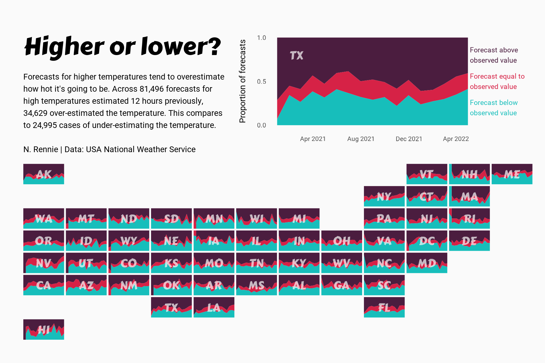
 View projectThis chart visualises the accuracy of high temperature forecasts made by the USA National Weather Service between January 2021 and June 2022, within a 12 hour window. Proportional area charts show...
 -
 View projectIn an increasingly worrisome scenario of unprecedented and extreme climate events, it is crucial to understand what causes and impacts humans and other factors have on the climate and health of our...
 -
 View projectThe choropleth map shows the mean Euclidian distance to roads for each of the 11.224 municipalities of Germany. The darker the color, the larger the average distance. The visualization makes use...
 -
 View projectThe Media Sustainability Index provides in-depth analyses of the independent media conditions in 21 countries using six indicators, and reveals benchmark insights into how media systems have...
 -
 View projectThis data experience compares our near ravenous appetite for cheap polyester clothes fuelled by fast fashion brands against the slowness of it’s discard and decay. The pile — a comparison Two...
 -
 View projectToday’s cities are finding it hard to be both livable and economically strong. Not one has truly balanced people, profit, and the planet, according to a new report on an index that ranks cities by...
 -
 View projectThe wolf – 2 sides of the discussion The wolf is back in the Netherlands and causing a big stir. While reading and listening about the wolf, I learned a lot, for example: - the wolf needs 4 kg...
 -
 View projectSpectrum is proud to debut the first-ever global map of autism prevalence. The interactive map provides a clear look at the distribution of studies on autism prevalence over time and space. It...
 -
 View projectThe interactive digital special project "Mercator. It’s a Flat, Flat World" tells the story of a famous map, published in 1569 by the Flemish cartographer Gerardus Mercator. We describe the...
 -
 View project"For centuries, atlases depicted what people could see: roads, rivers, mountains. Today, we need graphics to reveal the invisible patterns that shape our lives. Atlas of the Invisible is an ode to...


