
When it comes to sand mining, the Singapore government is often closed to scrutiny. As a result, it is often cast as a villain, guzzling sand from its neighbours while it grows bigger through...
-
 View projectService design methodologies can support the design of ad hoc visualisation tools focused on user needs. We present a case study co-development of a visualisation tool for the analysis of public...
 -
 View projectIn the summer of 2022, the water levels in the Yangtze, China’s largest river, hit a record low due to low rainfall in the river basin, reduced water flowing in from its upper reaches, and hotter...
 -
 View projectIntroducing "Carbon Emission of the World," a captivating Tableau dashboard designed to shed light on the pressing issue of carbon emissions. This visually compelling and informative report offers...
 -
 View projectA cotton data visualization showing a change in the ranking of cotton lint producers in a decade. Made using threads, needle and a cloth. The red threads denote a decline in the rank and the black...
 -
 View projectHousing availability in cities across America is failing to keep up with growing populations. To address this crisis, policymakers have begun to reconsider local zoning laws - the rules that limit...
 -
 View projectThe project comprises a publicly accessible, interactive webmap, aimed to communicate the rise and fall of London’s Low Traffic Neighbourhoods (LTNs) temporally over the course of the 2 year COVID...
 -
 View projectThe island of Hawaii (also known as Hawaii's "Big Island") is made of five volcanoes. This map visualizes these volcanoes in a simple, straightforward, and stylized way — the volcanic peak (center...
 -
 View projectMany of humanity’s most challenging issues are shaped by cross-border forces. To address, and report on, these issues, collaboration is critical. That is why the University of Miami and Universidad...
 -
 View projectThis is a infographic providing information about different types of tiles used in a design college building.
 -
 View projectFrom the 1930s to 1967, the federal government undertook a comprehensive effort to map perceived lending risk in neighborhoods of more than 230 cities across the US. This practice became known as...
 -
 View projectThe project attempts to understand the water consumption in the Design hostels. The data was collected with the help of the warden of the hostels and the plumbers who maintain the same. The...
 -
 View projectThe U.S. is filled with towns and cities that were named after foreign places: You can take a trip to Naples, N.Y., or Paris, Texas. — and go on a world tour without ever leaving your home state....
 -
 View projectHumans grow and waste food at a staggering scale. We devote half the earth’s habitable land to food production, while ultimately tossing one-third of that food. Simply using the food we grow and...
 -
 View projectExplore ongoing campus transformations. Track construction progress and completion dates through interactive visuals on our college map.
 -
 View projectA just transition to a net zero world needs to be inclusive. In this visualization, we explore equity and equality, the relationship between wealth and CO2 emissions, and the impacts of climate...
 -
 View projectBoar straying into urban areas has been a problem in many modern cities, the boar problem in Hong Kong refers to the increasing population of wild boars in urban areas. Rapid urbanization has...
 -
 View projectThe most diverse group of organisms on the planet are in trouble, with recent research suggesting insect populations are declining at an unprecedented rate. Amid deforestation, pesticide use,...
 -
 View projectThis quilt was designed utilizing a data set from Our World In Data, which tracked the increase in animals killed every year for meat production. In the quilt, red = cows, orange = pigs, and yellow...
 -
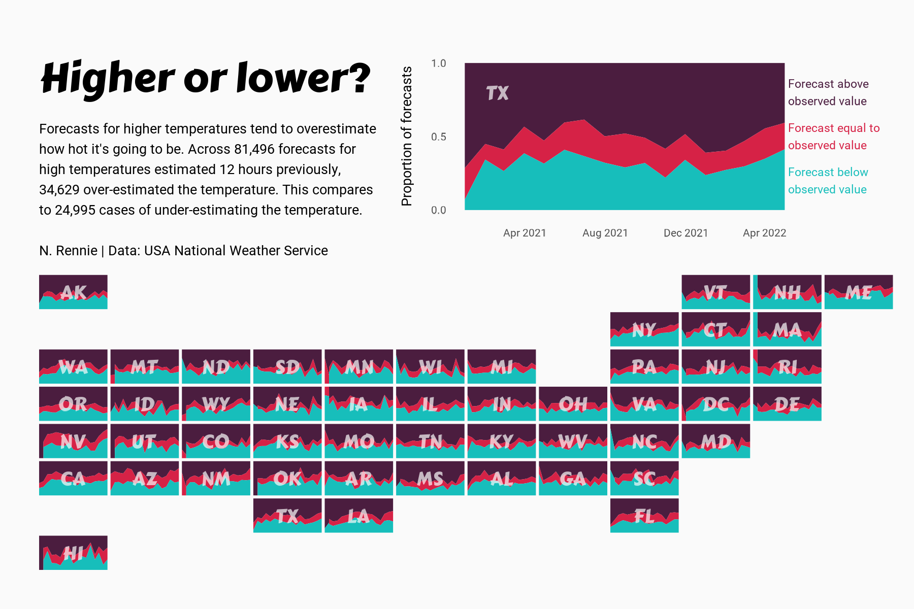
 View projectThis chart visualises the accuracy of high temperature forecasts made by the USA National Weather Service between January 2021 and June 2022, within a 12 hour window. Proportional area charts show...
 -
 View projectThis interactive narrative aims to illustrate the contrasting disparities in the lives and opportunities of children in Eastern and Western Europe, using the metaphor of children's books. Not all...
 -
 View projectThe report presents the generation, collection and treatment of waste in Mexico City. This process is represented in a data visualization that shows how many tons of waste are generated by the city...
 -
 View projectIn the US alone, we throw away 400 million paper coffee cups a day. That’s the equivalent of the volume of 13 Empire State Buildings of waste. In response to this staggering issue of waste, I...
 -
 View projectHow do you define the neighborhoods in your city? Axios created an interactive game that lets readers draw boundaries for select neighborhoods in their city and compare their responses to the...
 -
 View projectTo showcase the newcomers for hostel vacancy and warden can easily identify the number of rooms capacity left in the design.
 -
 View project"The Names on the Moon" is a stroll on the lunar surface through its feature names. We always see the Moon portrayed as a muted grey sphere orbiting planet Earth, marked by dark spots visible to...
 -
 View projectHot air balloon model by LowPolyBenjamin from CGTrader. Video: https://youtu.be/4rNZxua2_qE #MapboxGL #MapTiler #ThreeJS #WebGL #3D #maps #buildings #hotair #balloons #fly #nyc #manhattan...


