
With the accumulation of urbanization and the population, the demand for air travel is expanding. Through the airport flights and airline data of 230 cities, the works have an insight into how the...
-
 View projectThis visualization looks at the win percentage over the past 25 years for the NCAA college football pre-season top 25 teams. The year 1994 is shown at the 12:00 position and each year can be...
 -
 View projectWe humans have been making maps of the world since the beginnings of our culture, from the babylonian Imago Mundi to the latest big data based digital maps. Here a new world map is created from...
 -
 View projectTo mark China’s 40th anniversary of economic reforms we look at the impact they had on ordinary people by comparing the average family’s living space in 1978 to 2018. We also look at how peoples’...
 -
 View projectVisualization of bike sharing trips for a given time window of a business day to create a snapshot of commuting patterns. Selecting different periods of a day these patterns can be compared to...
 -
 View projectAn in-depth analysis and exploratory visualization of NOAA's weather data for Richmond, VA. The entrant has supplied multiple files for this project: [1] [2] [3] [4]
 -
 View projectWebeyez product oversees the front-end performance of your eComm website. It helps your tech team to identify, analyse and evaluate technical issues in comparison to your competitors....
 -
 View projectWhich neighborhoods in America offer children the best chance to rise out of poverty? The Opportunity Atlas answers this question using anonymous data following 20 million Americans from...
 -
 View projectThis poster series of data stories on the Cyclone Idai humanitarian response was a component of a Data-Art workshop to create data sculptures. To produce these posters, we collected open source...
 -
 View projectWater doesn’t respect borders. Globally, 263 lakes and rivers are shared between at least two countries, according to the United Nations. Of the 195 states in the world, 145 have at least one of...
 -
 View projectA visualizations and animated time-lapse video of the aging buildings in Cincinnati, Ohio from 1800 to 2016. Created by Jeffrey A. Shaffer at DataPlusScience.com. Additional link to YouTube...
 -
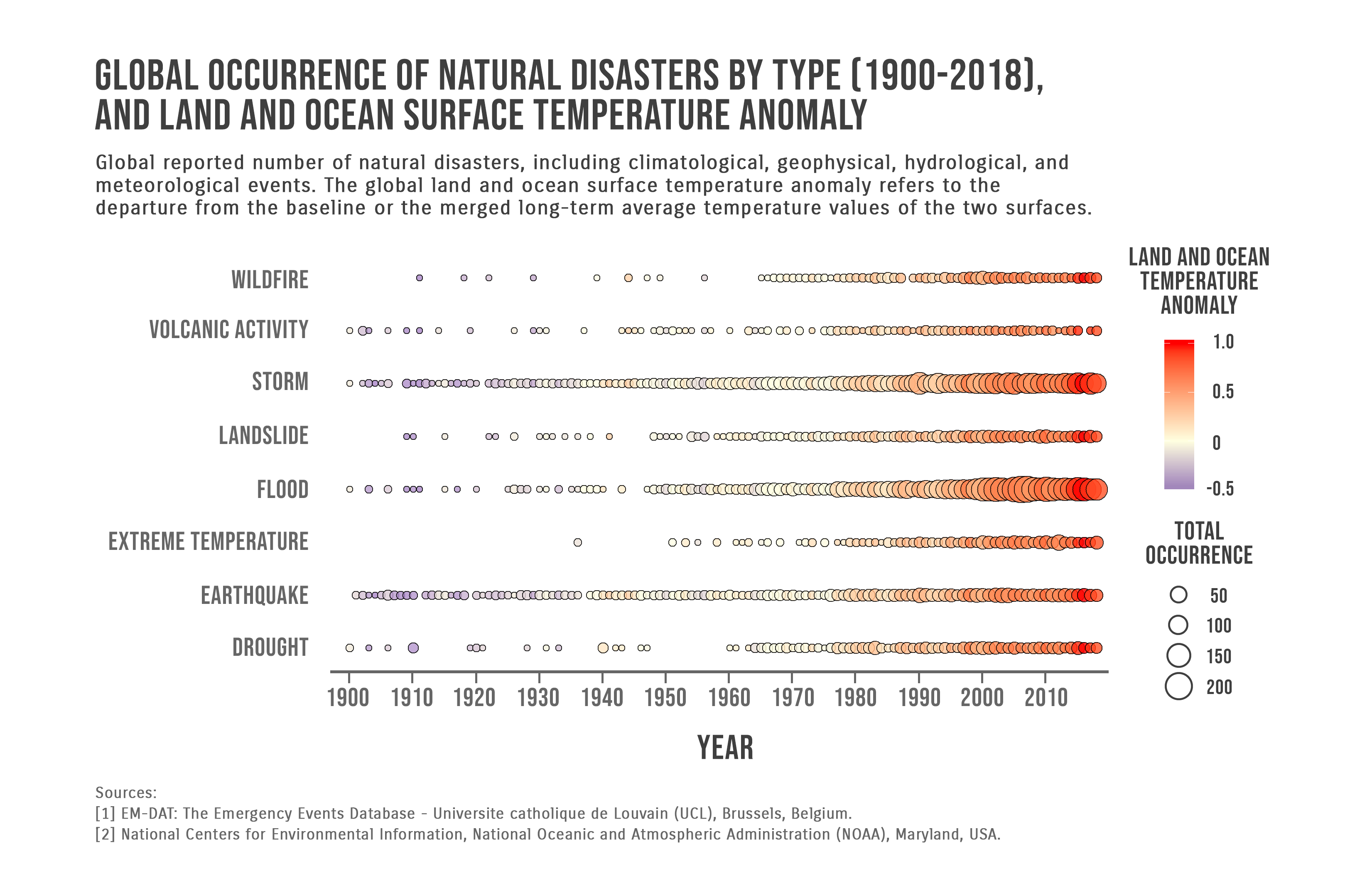
 View projectGlobal reported number of natural disasters, including climatological, geophysical, hydrological, and meteorological events. The global land and ocean surface temperature anomaly refers to the...
 -
 View projectUsing Tableau and Mapbox to create a map of bioluminescent species found on land and in the oceans on the east coast of Australia.
 -
 View projectWhen a train starts running from one station to the next station, conceptually, these two stations will temporarily be closer to each other. And that is exactly what this visualization shows:...
 -
 View projectIn order to allow an in-depth, more detailed exploration of the issues addressed in the interactive survey, a further step in the application user-flow allows people to access more complex...
 -
 View projectThese seven types of medical waste are the result of procedures, studies and general living habits around the hospital and in the world. They are produced and disposed of through different methods,...
 -
 View projectA digital PR campaign for Together Money. With three in four Brits saying it’s important to support shops on their local high street, but a worrying economic climate leading to national brands...
 -
 View projectLooking at the bunches of lab tests I had gathered since 2003, I decided to visualize my TSH lab results and other thyroid hormones. I was diagnosed with Hyperthyroidism and Graves Disease in 2003,...
 -
 View projectThe earthquake and tsunami in Indonesia caused widespread destruction and killed more than 2,000 people. As the amount of destruction was still coming to light, Reuters used a series of...
 -
 View projectThe R, Python and D3.js graph galleries are three websites that display more than a thousand chart examples with their reproducible code, using the three main programming languages currently used...
 -
 View projectThe GROW Observatory is a European-wide project engaging thousands of growers, scientists and others passionate about the land. For the Soil Moisture Maps project, we use local sensor and satellite...
 -
 View projectThis interactive globe shows the geology of Earth over the past 750 million years. Users can enter their locations to see where their homes are on the Pangaea supercontinent and other unique...
 -
 View projectThe soil of Korea is severely polluted. The Korea soil pollution campaign has utilized infographics to visually analyze the data collected through the Soil Measurement Network provided by the...
 -
 View projectDiceViz is a dice of data about Brasilian Small Busniness Economy. In Portuguese, the same word “dado” means "data" as well as "dice" (for games). In DiceViz face, was created a QR Code that,...
 -
 View projectThe goal of this project is to align the viewer’s choice of products and actions with their personal goals. There's so much unknown around ingredients used in our products, and this infographic is...
 -
 View projectThis graphic tells a small story about bicycle ridership in Seattle. It does so with a line chart, a sunburst, and a novel chart type: table cartograms (TGRAM) in a treemap. The TGRAM encodes...
 -
 View projectThe atmosphere of the kitchen in the Great cold of China. It shows the distribution, production and difference of traditional food in different parts of China during the 24 solar terms and the...
 -
 View projectA VR app for laymen and astronomers that visualizes X-ray data of astronomical objects from the ESA satellite XMM-Newton. Data of >1,000 X-ray sources generate unique data objects. Their sizes,...
 -
 View projectResearch is fundamental to the development of civilization. All products built today rely on the work of scientists who came up with discoveries and pioneered technologies, sometimes decades before...
 -
 View projectThe Strait of Hormuz is the highway for nearly a fifth of the world’s oil. But it’s located in the volatile region of the Middle East. Subsequently tankers using the route have been attacked, most...