
The IBM Watson News Explorer uses the AlchemyData News API to automatically construct a news information network and present large volumes of news results in an understandable fashion. It uses...
-
 View projectSerif and sans serif, funny and gothic, web-friendly and print-friendly. There are millions of free and paid fonts you can use. Although this is a good thing, it creates a bit of a problem: how to...
 -
 View projectCall it taxonomy, classification, even organization — it is what we use to make sense of almost everything around us. We put things in logical, labeled boxes that help us comprehend the world. The...
 -
 View projectHolobiont Urbanism is a research endeavor that sets out to study, map, and visualize the microbiome of New York City, in order to reimagine the city as more than a vast metropolis, but rather as a...
 -
 View projectA visualisation of ties between some of the stars of the Star Wars saga and the movies they have in common.
 -
 View projectIntersections of major roads have been given nicknames like “mixing bowl,” “spaghetti junction,” and “knot”—invoking images of tangled messes, but there's beauty in the chaos. Applying colors...
 -
 View projectThe birth of the printing press not only revolutionized education and knowledge, it also reshaped the design of letterforms. This opened up a whole industry for printers-scholars, type cutters, and...
 -
 View projectOn July 21, 2016, Donald Trump gave his acceptance speech for the Republican presidential nomination at the RNC. Since the beginning of the primary season, Trump has been accused by pundits of...
 -
 View projectNarcoData is a summary of 40 years of organized crime in Mexico. Organized crime in our country has overwhelming proportions that concerns itself not only with an expanding drug market, but has...
 -
 View projectThe visualization shows the meals described in 49 novels. The descriptions and the novels have been selected by Dinah Fried, who has collected them in the book Fictitious Dishes: An Album of...
 -
 View projectArtwork for Il Corriere della Sera - La Lettura about the Roman emperors (from Augustus to the last of the Western Roman Empire) , their causes of death and their years in power Source: Wikipedia
 -
 View projectMuch of the American West is in a prolonged drought. Western Water tracks the water levels of reservoirs across the western United States. It is a proxy for water availability in the selected...
 -
 View projectThe ribbons' sizes are proportional to the number of asylum applications by country of origin and destination. Destination countries connected to countries of origin by thick ribbons have...
 -
 View projectThe artwork shows on the left side the refugees who fled from their country of origin from 1980 to 2015, while on the right side the nations that have given asylum to refugees. The nations that...
 -
 View projectDuring the 2016 Australian election, ABC News ran an interactive tool that helped voters see how their views compared to the candidates' policies. More than 1.3 million people used the tool during...
 -
 View projectVideo data visualisation in motion design showing the urbanisation of the planet throughout the ages. Since 2008, more than half of the humain beings live in cities. Every second, 2 people add up...
 -
 View projectThere have been more than 22 million weddings in England and Wales over the last 70 years. Visualising data from the Office for National Statistics allowed to retrace patterns in the British...
 -
 View projectOlympians are young, supremely healthy people who’ve been training with the intensity of combat troops for years. Suddenly they’re released into a cocoon where prying reporters and overprotective...
 -
 View projectExamine Miles Davis' legacy by sorting through every Wikipedia page (in English) on which he’s mentioned.
 -
 View projectFor pet lovers, life without furry friends in just not an option - even when there’s a garden to consider. Not to worry! Just follow these easy pet-proofing steps to keep your pet safe when...
 -
 View projectArtwork for "La Lettura". Data extraction by ItaliaNLP Lab. The visualization shows the most frequent terms and their proximity in Svetlana Alexievich's books. For each book are indicated the 10...
 -
 View projectHow old are you? How old were the great and the good when they peaked, or got their big break? WHO old are you?
 -
 View projectWage Islands is an interactive installation about wage and housing inequality in NYC. It's a 3d topographic map of monthly housing costs submerged in water to show where New Yorkers can afford...
 -
 View projectA year after Donald Trump launched his presidential bid, and against all expectations, the business mogul is the presumptive GOP nominee. Who supported him? How did he take over a Republican...
 -
 View projectThe project investigates the problem of air pollution in modern megapolices. The main purpose was to tell about the influence of different urban systems on environment, their correlation and role...
 -
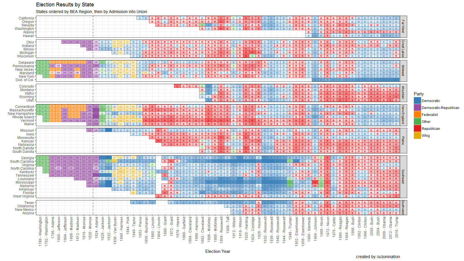
 View projectOpen Source visualization of Election Results by state, party, year, and candidate, sorted by region.
 -
 View projectThe artwork represents the revenues of all Star Wars episodes (in the middle), and their actors (outer circle), according both to all the films they took part in and to only those of the saga....


