
When geometry and human intuition meet: What becomes of the intersection between pragmatic visual tools and emotion?
Everybody worries about something. Worrying is an act of the everyday that...
-
 View projectCONTEXT: The ocean has a strong influence on Earth's weather and climate, affecting our daily weather and shaping long-term climate changes. In the realm of scientific studies, acquiring the...
 -
 View projectBeautiful Trash visualizes a week of trash collection routes in Cincinnati, OH using the open data from the City of Cincinnati. In addition to the visualization, there is also a YouTube video...
 -
 View projectSiria: Danni Collaterali (Syria: Collateral Damages) is a visual journalism project which sheds a light on the destruction of historical heritage during the Syrian civil war. Text insights and maps...
 -
 View projectThe shark is the most ferocious fish in the ocean. The shark existed on the earth three hundred million years before the advent of the dinosaurs, but we did not know that there were many different...
 -
 View projectPhantom Islands are artifacts of the age of maritime discovery and colonial expansion. During centuries of ocean exploration these islands were sighted, charted, described and even explored – but...
 -
 View projectNew York City's transportation system moves millions of people every day, from MTA buses to regional Metro-North rail lines to the omnipresent subway . Multimodal Symphony animates 24 hours of NYC...
 -
 View projectThis work presents the availability of water in the Portuguese basins (sets of dams). The map on the right indicates which regions hold the biggest volumes of water (Guadiana and Tejo). The...
 -
 View projectMangrove forests are one of the most productive marine ecosystems in tropical and subtropical coastal areas. They have the characteristics of both terrestrial and marine ecosystems and are also...
 -
 View projectThis visual article presents an analysis of how three Spanish cities, Madrid, Bilbao, and Valencia, have changed in relation to their rivers. Despite rivers always being vital for cities and their...
 -
 View projectHeavy rainfall and freezing winters – how has the climate changed in the Gulf Cooperation Council (GCC) region over the last 40 years? This multi-page data tool was created by Aeon Collective,...
 -
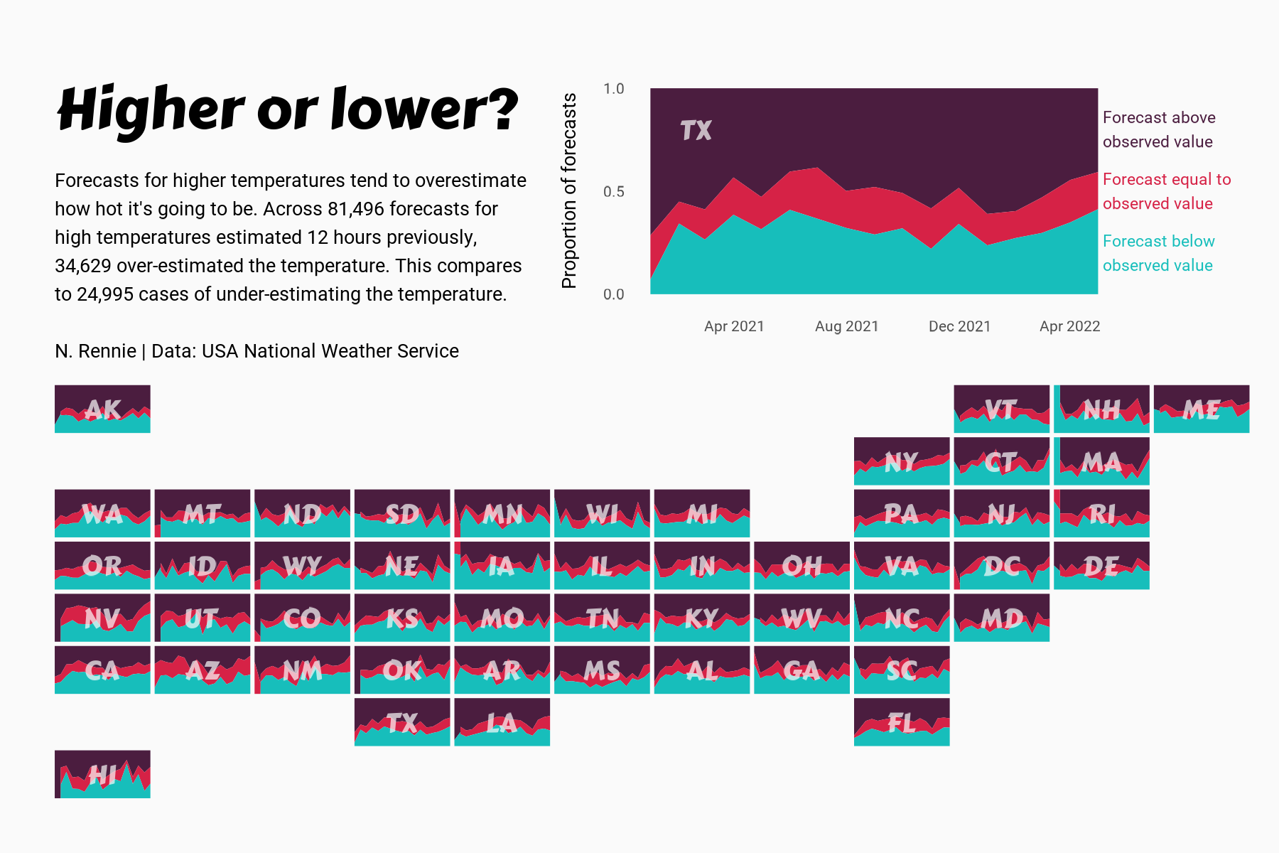
 View projectThis chart visualises the accuracy of high temperature forecasts made by the USA National Weather Service between January 2021 and June 2022, within a 12 hour window. Proportional area charts show...
 -
 View projectXXXY City (Triple X, Y City) is a data visualization project analyzing the difference between women and men in New York City on seven factors – education, occupation, income, age, sex...
 -
 View projectThe project was done in partnership with Open Development Mekong to draw attention to pressing developments of the region that will ultimately affect the most disadvantaged. It also attempts to...
 -
 View projectVisualizing the 2016 metric tons of coffee produced and the coffee belt between the tropics of cancer and capricorn.
 -
 View projectA lot of people look for jobs at big companies because they can be great places to build a solid career. Unfortunately, if we measure the size of a company in terms of annual revenue, there may...
 -
 View projectAnimal movement represents the continuous succession of locations of an individual over time. By changes in movement, animals react to both internal stimuli and the environment. State-of-the-art...
 -
 View projectThink of all the things you observe during the day. How much time do you take to actually stop and notice them? There is so much data in our environments, sometimes it just takes a moment of pause...
 -
 View projectA large-format data visualization depicts the complex narrative of the 2003 Northeast Blackout, which began imperceptibly in Ohio over the course of four hours and cascaded within eight minutes...
 -
 View projectLess than 20 years ago, only three cities in China had subways. If you didn’t live in Beijing, Guangzhou, or Shanghai, underground travel was a complete mystery. Today, there are more than 60 metro...
 -
 View projectI got curious about understanding whether pub names in the UK can tell us a little bit about the people who drink there. So I produced a bunch of maps that would help investigate this. Some names...
 -
 View projectRoad killings in Taiwan are becoming more and more severe, with gray in the background to indicate "roads", and red gradients for species extinction to show the spread of blood, like only...
 -
 View projectI did a survey and observed cycles in and around my college campus based on their condition if they are geared or non-geared, where they are located, whether they are locked or not and much more....
 -
 View projectThe visualization is created using Tableau software, and some design elements are created with MS PowerPoint. The viz shows the rain weather events across the United States. The data coverage is...
 -
 View projectWhere do the people with the lowest salaries live, and where the people with the highest? Zeit Online shows the development of the past 20 years for all municipalities.
 -
 View projectSnow is vital to the environmental health of the western United States. Unlike rainfall, it doesn't come as one burst that's here and then quickly gone. Instead, it tends to accrue over the winter...
 -
 View project"Spain lives in flats" is an innovative and interactive journalistic project by elDiario.es that analyzes the footprint of more than 12 million buildings to map the height of Spanish cities in 3D...
 -
 View projectSince the nuclear accident caused by a powerful earthquake in 2011, Japan has been storing a huge amount of contaminated wastewater in the Fukushima Daiichi Nuclear Power Plant. Now that it almost...

