
“It worked very well in New York… it brought the crime rate WAY DOWN” – Donald Trump
“It was ineffective” – Hillary Clinton
“The argument is that it is a form of racial profiling” – Lester...
-
 View projectDespite resistance from environmentalists, Native tribes, and local communities, Enbridge moves forward with its pipeline plans. But at what cost? Enbridge Inc. is an international pipeline...
 -
 View projectVisualizing Great Wall is an infographic book demonstrating Great Wall of China through 33 topics. Built hundreds of years ago, the Great Wall is usually considered merely as a tourist...
 -
 View projectThe A-Z of London Planning directory serves as a go-to for anyone working within, or with a vested interest in the London property market. It has been designed to provide a visual overview of the...
 -
 View projectRegional Weather Myths explores several questions: Are our summers getting warmer and drier? Do real summers and winters even exist anymore? Are floods on the agenda in the region? It all started...
 -
 View projectState of the environment reporting is a vital process and resource in environmental management. In Australia, the report is prepared every five years by an independent team of expert authors. The...
 -
 View projectThe 2016 count of the homeless population, taken in January, revealed that our county has more than 43,000 people living on the street or in shelters. (Long Beach, Glendale and Pasadena were not...
 -
 View projectIndia's pursuit of economic growth to improve citizens' quality of life presents a challenge in balancing development with environmental sustainability. Navigating the socio-cultural and economic...
 -
 View projectA few weeks ago I set on trying out new WebGL 2.0 features with deck.gl. WebGL 2.0 brings plenty of new goodies to be used for game development, creative coding and data visualization like...
 -
 View projectThe island of Hawaii (also known as Hawaii's "Big Island") is made of five volcanoes. This map visualizes these volcanoes in a simple, straightforward, and stylized way — the volcanic peak (center...
 -
 View projectThe New South Wales population is forecast to increase by 2.71 million people before 2036, with a net increase from overseas migration of over 1.37 million people. Working with the NSW Department...
 -
 View projectThe design work for this book, its maps and graphics, was commissioned by Instituto Socioambiental. The book is the product of a partnership between RAISG (Amazonian Network of Georeferenced...
 -
 View projectA lot of people look for jobs at big companies because they can be great places to build a solid career. Unfortunately, if we measure the size of a company in terms of annual revenue, there may...
 -
 View projectVideo documentation: https://vimeo.com/751860865 How did people live in the 8th century? In an impressive way, users of the interactive application "Viking Walks" embark on a digital tour of...
 -
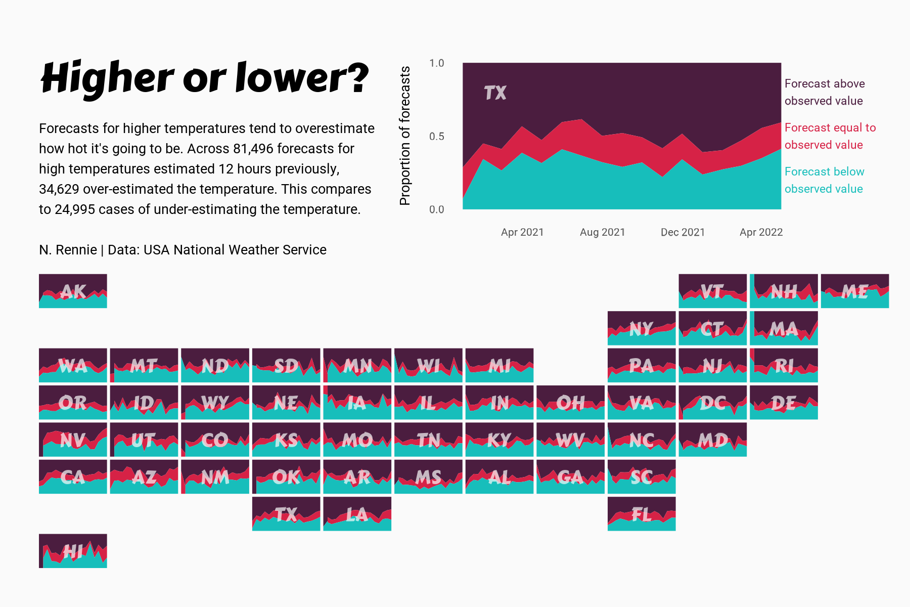
 View projectThis chart visualises the accuracy of high temperature forecasts made by the USA National Weather Service between January 2021 and June 2022, within a 12 hour window. Proportional area charts show...
 -
 View projectPlanet’s goal of imaging the entirety of the Earth every day became achievable with the unprecedented fleet of small satellites, called “doves”. The animation showcases one day in the life of these...
 -
 View projectDeputy Head of Infographics for the South China Morning Post, Adolfo Arranz, uses historical data for his series of infographics about globalisation’s beginnings in the 16th century, when the...
 -
 View project“Flights to Rome” is a data visualization art project showing the entire global mobility network of flight and road infrastructure in a single image. It visualises for the very first time literally...
 -
 View projectThis project is an interactive website illustrating the dynamics of Shenzhen through data analysis on 165 metro station areas. With this metro searching tool, the readers can have a better idea of...
 -
 View projectThis publication explores plastic bag usage in the UK, considering the juxtaposition of perspectives from the supermarkets and in turn the consumers. The data presented visualises: The number of...
 -
 View projectUnhappy in your current locale? Delayed Gratification magazine compiled the definitive meta-list of global indices – ranking everything from press freedom and prosperity to happiness and the gender...
 -
 View projectWeather is a topic that often comes up in casual conversation, and in an international world of many backgrounds, I have been increasingly interested in the weather and length of the day, which is...
 -
 View projectThis interactive infographic captures the beauty and of population both at the country level and for each continent. Hovering over a country will highlight the country in the map key at the top....
 -
 View projectThis visualisation explores which countries in 2010 produced the largest amount of plastic waste and what percentage of this was inadequately managed, but more importantly how does this management...
 -
 View projectSince the launch of Sputnik 1 in 1957, 29 spaceports around the world have been used to launch satellites to orbit. This interactive map and timeline shows the cumulative launches from each...
 -
 View projectThis map, created using the U.S. Department of Defense's THOR dataset, shows every recorded bombing mission of the Vietnam War. Each mission is plotted as a single semi-transparent point....
 -
 View projectAn animated flow map showing numbers of commutes in the Netherlands in 2016. Commutes are shown as trains, and locations which attract them are shown as glowing stars. Inspired by the cf. city...
 -
 View projectThis is a collection of notebooks about drawing and animating ‘waterlines’—an old technique for showing water in maps—in JavaScript. The notebooks walk through different approaches in code, connect...
 -
 View projectPhantom Islands are artifacts of the age of maritime discovery and colonial expansion. During centuries of ocean exploration these islands were sighted, charted, described and even explored – but...
 -
 View projectNumber of cherry blossom trees per 293 x 365 meters (represented by each hexagon) planted in Washington D.C.