
Confessions of a Blog-a-holic is an infographic displaying the blogging habits (frequency and times of posts) of a Graphic Design student between 2009 and 2011.
-
 View projectTurnover and financial performance of international agencies operating in Italy. One hundred companies, 3 years of data.
 -
 View projectIt was the BBC that came up with the format, which pairs celebrities with professional dancers for a televised ballroom dancing competition. The first series began on 15 May 2004. Later that year,...
 -
 View projectThis graphic is a visualization of the history of US state boundaries. It gives an overview of current and past state boundaries throughout the country's entire history, combining time and space in...
 -
 View projectThe interactive visualisation shows where the government money is spent. Readers can see the data by department and functional classification.
 -
 View projectLiving Ruins is a fictional environmental campaign aimed to educate people about the multitude of benefits that coral reefs bring to tourism, fishing industries, coastline and biodiversity...
 -
 View projectIt appears that we are witnessing a global health crisis. According to the World Health Organization, malnutrition is the greatest single threat to human health in developing nations. Yet this...
 -
 View projectA visual representation of the number of Iraqis estimated to have been killed as a direct result of the invasion of Iraq in 2003. The chart compares the official estimates against UK public...
 -
 View projectBillionaires are the richest of the rich. Many young entrepreneurs hope to one-day reach this ultimate financial milestone. But before these entrepreneurs are allowed to join this group, they first...
 -
 View projectAfter the disappearance of Flight 370, readers had a hard time understanding how difficult the search for plane's black box would be. This graphic shows just how challenging the search is.
 -
 View projectStadtbilder is an attempt to map the digital shape of cities. While traditional maps show us buildings, roads and physical infrastructure, these maps reveal where and in which form the city is...
 -
 View projectIn this data visualisation, we chart the source material for the highest-grossing film every year since the original blockbuster, –Gone with the Wind' in 1939. Many were inspired by comic books, TV...
 -
 View projectThis infographic shows the first 100 historical figures in order of influence according to Pantheon, a Macro connections group of the MIT Media Lab of Boston project which took into account...
 -
 View project'The Beginning and the End' compares the completely abstract notions of the creation of the world, written in Genesis, and the apocalypse, written in Revelation. Each piece of visual data...
 -
 View projectNew York City's urban forest provides numerous environmental and social benefits, and street trees compose roughly one quarter of that canopy. This map shows the distribution and biodiversity of...
 -
 View projectThe physical charts are an attempt to make data and data visualisations legible to ordinary people in their daily lives. In response to the increasing sophistication of data visualisations and the...
 -
 View projectCartographers are tasked with making the physical world understandable through graphical display. Abstract spatial data is given context and translated through elements such as north arrows, scale...
 -
 View projectOur baseball chronology series was developed for an exhibit featured at the Baseball Hall of Fame in 2015. The series of four prints shows a visualized history of the major leagues: which teams...
 -
 View projectSpread artwork for Wired US Infoporn section (August 2015 Issue). The map shows hurricanes in America since 1900, color-coded according to category and power. Source: NOAA
 -
 View projectDouble pages for Wired about the italian public health according the death rate in the hospital per disease. The visualization shows the main killers and the five best and five worst hospital...
 -
 View projectWhile Wikipedia is a most modern creation, its content reflects a historical accumulation of facts and attention. This map of London shows the density of articles in Wikipedia associated with...
 -
 View projectThis map includes all movie filming permits issued by the Mayor's Office of Film, Theatre, and Broadcasting for the years 2011 through 2013. It comprises a total of 517 movies and 17,241 filming...
 -
 View projectIt is an infographic about the relationship between the lack of education and the no use of contraceptives of teenagers (15-19 years) in Mexico during 2014
 -
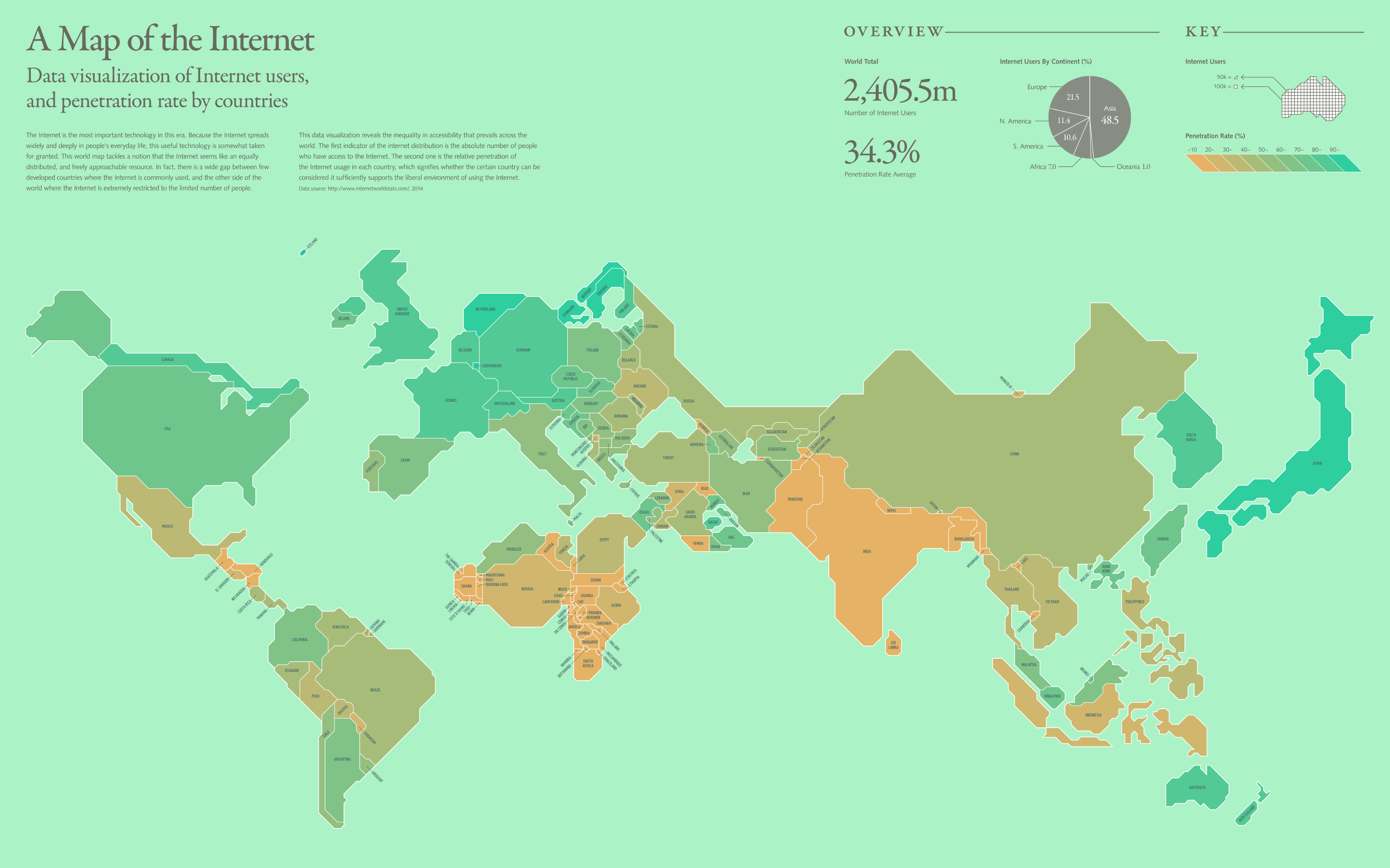
 View projectThe Internet is the most important technology in this era. Because the Internet spreads widely and deeply in people's everyday life, this useful technology is somewhat taken for granted. This world...
 -
 View projectA visualisation of the links between past, present and future films, shorts and TV shows in the Marvel Cinematic Universe. @FlexibleHead
 -
 View projectHeights of 13million buildings in England. Data is from LiDAR data & building outlines open data. The visualization uses vector map tiles (from Open Street Map basemaps), MapboxGL, Angular JS,...
 -
 View projectTo celebrate the World Cup 2014 in Brazil, we created this interactive infographic that depicted every shirt worn by the 32 competing teams at every world cup they'd qualified for. Extensive...
 -
 View projectThe visualization shows the meals described in 49 novels. The descriptions and the novels have been selected by Dinah Fried, who has collected them in the book Fictitious Dishes: An Album of...

